
Draft Bradford District Local Plan - Preferred Options (Regulation 18) February 2021
Wilsden
Introduction
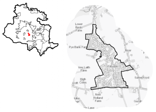
5.27.1 Wilsden is a small village located approximately 1.5km to the north west of the Bradford urban area and around 2.5km from Bingley. The settlement sits to the north of the B6144 Haworth Road, connecting Bradford to Haworth. Main Street / Harden Lane runs north through the centre of the village connecting Wilsden to Harden. It is one of nine settlements located in the South Pennine Towns and Villages sub-area. Wilsden falls within the Shipley Parliamentary Constituency and within the Bingley Rural Ward.
Figure 1: Location Plan
5.27.2 The settlement has a population of 3,758 and a large percentage of this (58. %) falls within the working age category (16-64). Wilsden has a significantly higher proportion of persons over 65 (27.6%) compared to the West Yorkshire (16.7%) and England (18.4%) averages. It will be important to consider the needs of a growing, older population over the lifetime of the plan. The proportion of younger people (14.1%) is notably lower than the West Yorkshire average (20.6%) and again this needs to be factored into future planning and its implications for service provision. The ethnic composition of Wilsden is primarily made up of people who identify themselves as White British (95.7%). This is a notably higher proportion than the West Yorkshire average (78.4%), but is similar to the other smaller rural settlements in the District.
5.27.3 Wilsden Parish Council are in the process of preparing a Neighbourhood Plan for the parish area which will provide policies for managing new development in the settlement and complement policies in this Local Plan.
Planning for Prosperity
5.27.4 The Local Plan settlement hierarchy identifies Wilsden as one of Bradford district's 11 Local Service Centres. This means that it will see a smaller scale of development, comprising both market and affordable housing, as well as the protection of its local centre to help ensure the continued provision of economic activity in the area. No one in Wilsden is living in the most deprived 20% of areas in England, as outlined in the Indices of Multiple Deprivation (2019).
Economy and Employment
5.27.5 Economic activity rates are relatively positive for Wilsden with 72.2% of the resident population economically active compared to the West Yorkshire average (68.5%). Average household income at £43,700 is notably higher than the West Yorkshire average (£38,499). The main employment sectors that the residents of Wilsden work in include retail, health and social work, and education.
5.27.6 Employment opportunities within the settlement mainly consist of retail and service jobs located in the shops and facilities situated along Main Street. There is also health and education provision, car repair and some industry, with Bingley Brewery located off Shay Lane. Otherwise, in order to access a wider range of employment opportunities, residents need to commute to the larger centres of Bradford, Bingley and Keighley.
5.27.7 Business Register and Employment Survey (BRES) data indicates that the three largest industry groups by workforce jobs (all people in employment) are: retail industry (19.5%), health (16.8%) and education (10.5%).
5.27.8 The local plan does not seek to specifically allocate employment land within this Local Service Centre, but the plan is supportive of appropriately sited and scaled economic growth and diversification within the Pennine Towns and Villages.
Retail
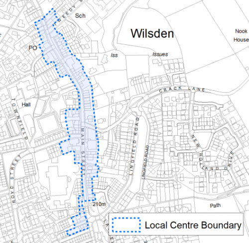
5.27.9 The 2019 Retail and Leisure Study concluded that Wilsden appears to be stable and performing well. It has a good number and range of shops. There are 26 retail units within the centre, with the convenience offer being centred around the Co-op Food store and is supported by a butcher, delicatessen and off license. There are also a small number of other retail outlets for example a bridal-wear store and car sales. In addition, there are a range of services such as hairdressers, a beauty salon, takeaways, restaurant and public houses. Figure 2 shows the boundary of the local centre.
Figure 2: Wilsden Local Centre
Transport and Access
5.27.10 Wilsden is connected to the wider road network of the B6144 to the south and the B6429 to the north from Main Street/Harden Lane which runs through the centre of the village. These roads connect Wilsden to Bradford, Bingley, Cullingworth, Harden and Haworth. Car ownership in the settlement very high with around 87.4% of households having at least one car. This is significantly higher than the West Yorkshire average (70%) and reflects the more rural nature of the settlement with a limited number of public transport options and a smaller range of retail outlets and facilities, meaning residents have to travel further to access such services.
5.27.11 The village benefits from three services: i) the 616/619 – run by First Buses which provides a half-hourly service between Wilsden and Bradford and Eldwick (Bingley); and ii) the K17 Keighley Jets – run by The Keighley Bus Company (part of the Transdev Blazefield Group) which provides a two-hourly service between Wilsden and Bradford and Keighley.
5.27.12 Wilsden is reliant on road transport as the nearest railway station is around 4km away in Bingley. Services from Bingley provide connections in to Bradford, Leeds and beyond and also up to Keighley and Skipton.
5.27.13 There are numerous footpaths and bridleways leading out of the settlement into the countryside and connecting with the wider public rights of way network. This provides opportunities for walking, cycling and horse riding.
5.27.14 In relation to digital accessibility, average broadband download speed in Wilsden is almost 27 megabytes per second which is below the West Yorkshire average of 44.57. There are no premises where the speeds are below the Universal Service Obligation (USO)[1].
Planning for Homes
5.27.15 There are 1,703 dwellings within the settlement area. A large proportion of these properties are owner occupied (83.2%) which is significantly higher than both the West Yorkshire (63.4%) and England (64.1%) averages. Nearly 12% of the remaining properties are within private rented tenure, with just 5% being of a social rented tenure.
5.27.16 There are a mix of house types in Wilsden, with the highest proportion being semi-detached properties (43.2%), this reflects the nature of the housing developments which have taken in the village over the latter part of the twentieth century. This is a notably higher proportion than the West Yorkshire average (36%). There is also a higher percentage of detached properties (23.1%) compared to the average (16.4%), but a lower percentage of terraced properties (27.2%). These terraced properties are mainly focussed around the central part of the settlement and are linked to the settlement's historical growth with the textile industry.
5.27.17 The average house price (all types) in Wilsden is £164,229 which is notably lower than the West Yorkshire average of £183,194. The average house price is below the sub-regional figures for all house types as detailed in Figure 3.
Figure 3: House Prices in Wilsden
|
Average house price (all types of housing) (Land registry Sept-19 to August-20) |
Average house price (detached) (Land registry Sept-19 to August-20) |
Average house price (flats) (Land registry Sept-19 to August-20) |
||
|
£164,229 |
£272,625 |
£102,500 |
||
|
West Yorkshire average = £183,194 |
West Yorkshire average = £324,872 |
West Yorkshire average = £128,299 |
||
|
Average house price (semi-detached) (Land registry Sept-19 to August-20) |
Average house price (terraced) (Land registry Sept-19 to August-20) |
Households in Council Tax Band A (Valuation Office Agency (VOA) 2020) |
||
|
£173,118 |
£123,684 |
244 |
||
|
West Yorkshire average = £178,439 |
West Yorkshire average = £132,430 |
13.7% (West Yorkshire average = 43.1%) |
||
|
Households in Council Tax Band B (VOA 2020) |
Households in Council Tax Band C (VOA 2020) |
Households in Council Tax Band F-H (VOA 2020) |
||
|
329 |
675 |
156 |
||
|
18.5% (West Yorkshire average = 20.2%) |
38.0% (West Yorkshire average = 17.6%) |
8.8% (West Yorkshire average = 4.3%) |
5.27.18 Wilsden has a significantly lower percentage of properties falling into the lowest council tax band and also a notably low proportion of social rented properties which may indicate that there are affordability issues to be addressed within the settlement. The village is within Zone 2 in terms of the housing value areas in the District and therefore would see a requirement of 20-25% affordable housing on new developments.
5.27.19 The delivery of new housing is a key part of the development strategy for Wilsden. This will ensure that the housing needs of local people can be met, both in terms of market and affordable housing. New housing will also allow for the modest growth of the settlement, to attract new residents and to help sustain the provision of services and facilities.
5.27.20 Policy SP8 in the local plan sets out a minimum requirement of 125 dwellings to be delivered in Wilsden during the plan period. These will be delivered through a mix of committed sites (those under construction or have planning permission but have not yet commenced) and allocations. Table 1 below sets out the housing position for Wilsden, which also includes the application of non-implementation or discount rates for planning permissions and allocations.
Table 1: Wilsden - Summary of Housing Requirement and Supply
|
Housing Target |
125 units |
|
Carried Forward Commitments |
13 |
|
Commitments Discounted by 10% |
12 |
|
Remaining Allocation Requirement |
113 |
|
Identified Allocations |
130 |
|
Allocations Discounted by 10% |
117 |
|
Total Supply Contribution from Allocations |
117 |
5.27.21 Once the commitments are discounted and removed from the supply, this leaves a residual allocation requirement of 113 units. The evaluated total site supply of housing units from the preferred allocation site equates to 130 units which is in turn discounted by 10% for non-implementation or under delivery leaving a final allocation contribution of 117 units.
5.27.22 One small site which is part previously developed and within the settlement, along with two Green Belt sites have been identified as the preferred housing options for Wilsden to meet the housing requirement. In delivering the target for new homes in Wilsden it has been necessary to make some changes to the adopted green belt. Policy SP5 sets out The Councils approach and justification for green belt releases to accommodate new development and lists the sites proposed for allocation which current lie within or partly within the green belt. Further information on these proposed allocations is set out in Table A and are identified on the Policies Map and the Site Pro Formas below, together with the local strategies map for each plan area. Development of site allocations should be in accordance with specified development guidelines and approximate site provision figures and all other relevant policies of this Local Plan. The Council will be supportive of additional proposals for new homes on additional small sites, particularly those that provide a redevelopment opportunity to bring forward land which has been previously used. Support will also be provided to developers who wish to redevelop larger sites and/or buildings for new homes not currently identified, subject to all relevant policies in the Local Plan.
Planning for Places and Communities
Green Belt, Natural Landscape and Historic Character
5.27.23 Wilsden is surrounded by Green Belt land, with the boundary being tightly drawn along the existing built form, leaving little room for further growth and expansion.
5.27.24 There are two landscape character types which surround Wilsden. To the South, East and West the dominant landscape character type is Mixed Upland Pasture. This landscape has a moderate strength of character, but is sensitive because of its prominence and openness. Development may have a greater impact on the character of the area than in more enclosed landscape types. To the North East of the village there is also an area of Wooded Valley landscape. This landscape has a strong character, high historic continuity and visibility. Although these areas are fairly enclosed, development is not appropriate due to the steeply sloping wooded land.
5.27.25 Wilsden Conservation Area covers the historic core of the settlement stretching along Main Street and including a number of historic buildings. There are 37 Grade II Listed Buildings within the settlement boundary of the village which mainly consist of private residential properties. In terms of other heritage assets there are no scheduled monuments or known archaeological sites within the settlement itself, but there are some identified in the surrounding countryside. Of particular note is the prehistoric enclosed settlement north of Shaygate Farm.
Green Infrastructure, Ecology, Open Space and Flood Risk
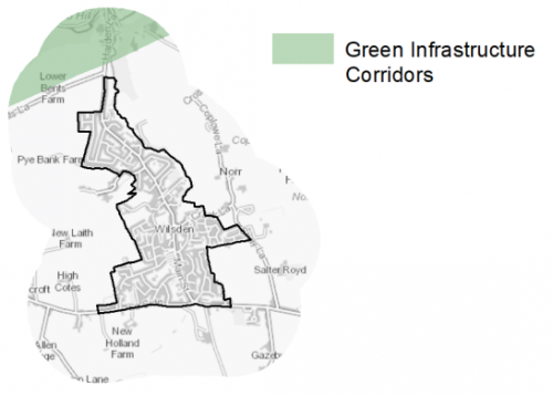
5.27.26 Land between Wilsden and Harden, form part of the District's Green Infrastructure (GI) network and should be protected and enhanced. These areas are multi-functional in nature and help to deliver benefits for biodiversity, reduce flood risk, provide public rights of way, and areas of open space. Consideration should be given to improving connections to these areas of Green Infrastructure in particular how areas of woodland to the north east of Wilsden could be enhanced to extend the Green Corridor, and how new developments can aid this process improving links between sites. Figure 4 is a map showing GI on the edge of Wilsden.
Figure 4: Green Infrastructure Corridors
5.27.27 There are no designated Local Wildlife Sites or Local Nature Reserves within or immediately adjacent to the settlement. However, there are notable areas of priority habitat to the north east of the village which follow the line of Wilsden Beck and mainly consist of areas of deciduous woodland. There is also an area of mixed lowland woodland which adjoins the north east of the settlement which forms part of the wider Wildlife Habitat Network – which connects spaces together to allow for the movement of species.
5.27.28 Wilsden falls within the 7km zone of the South Pennine Moors SPA/SAC internationally designated wildlife site. Within this zone new developments will need to contribute to measures to mitigate against the potential increased recreational impact of the increase in population.
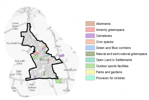
5.27.29 There are 19 sites classed as open space of various types which cover an area of 11.21ha serving the residents of Wilsden. Key open space sites include Wilsden Park (including the play area), Wilsden Recreation Ground and Main Street Allotments. Although the village is surrounded by open countryside there are deficits of most types of open space within Wilsden and whilst residents can travel to other nearby settlements with greater levels of provision, there is still a need to seek opportunities to provide additional, useable open space within Wilsden to help meet the relevant standards. Residents should have local access to a range of different types of open space, and any new developments should provide new spaces to meet those needs. Additional outdoor sports spaces, parks and play areas are the types of open space that are in most need in the village. Figure 5 shows the location and type of open space in Wilsden
Figure 5: Wilsden – Open Space Overview
5.27.30 Wilsden Beck is located to the east of the settlement and there are areas of land around the beck which are within Flood Risk Zones 2 and 3. However, the majority of the settlement is not at risk from fluvial flooding and is within Flood Risk Zone 1. There are large areas of the settlement which are at risk from surface water flooding particularly in the south of the village around Badgergate Avenue and also all the way along Main Street. This is in part because of the topography of the village with the settlement sitting in a valley and water flowing down the valley sides to the central spine of the village. In some of these areas the risk is high at 1 in 30 years. Some of these areas follow the culverted line of Wilsden Beck.
Community Infrastructure – Education, Health and Utilities
5.27.31 Wilsden has a range of community facilities available to meet the day to day needs of local people. These consist of local shops, Wilsden Village hall (which provides a community hub at the centre of the village and includes the library), restaurants/takeaways, parks and play areas, places of worship, public houses and other services such as a car sales and repair garage.
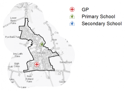
5.27.32 Wilsden Primary School is an Academy school located off Tweedy Street and is part of the Focus Academy Trust. It is a two form entry school offering up to 60 places a year. There are a number of secondary schools within reasonable proximity of Wilsden: Parkside School, Cullingworth (2.5km to the west), Dixons Academy, Cottingley (3km to the north east) and Beckfoot Upper Heaton, Bradford (3.5km to the east).
5.27.33 There is one GP surgery located on Long Bob Court, off Wellington Road, offering primary care services to local residents. Secondary (acute) healthcare is provided at Bradford Royal Infirmary, around 4.5km to the south east of the village. There is also a dental practice, optician and pharmacy within the village. Figure 6 shows the location of local services in the village.
Figure 6: Wilsden – Schools and GP Practices
5.27.34 When planning for the long-term development of Wilsden, it is vital that new development is supported by the appropriate infrastructure. The capacity, quality and accessibility of services and facilities are all key components in ensuring people can enjoy living, working and visiting the area. The Council will continue work with key infrastructure providers and others including the Local Education Authority, Clinical Commissioning Group and utilities providers to determine the impacts of future growth and development on local infrastructure Plan and as part of the Regulation 19 stage of the local plan.
|
Local Area Strategy and Plan - Wilsden The key elements of the local strategy for Wilsden include:

|
(23) Consultation Question 140
Wilsden Local Area Strategy
The Local Plan sets out a local area strategy for Wilsden.
Q. Please provide any comments you may have on the area strategy?
If you have an alternative to the approach undertaken, please provide further details and evidence in support.
Preferred Site Allocations and Site Pro Formas
5.27.35 The preferred housing site allocations are detailed below in Table A. This table is subsequently followed by site pro formas providing a summary of key site information and characteristics.
Table A: Housing - Preferred Allocations
|
Site Ref |
Site Name |
Dwellings |
|
WI1/H |
Crooke Lane |
10 |
|
WI2/H |
Crack Lane |
40 |
|
WI3/H |
Moorside Farm, Wellington Road |
80 |
|
Total |
130 |
(27) Consultation Question 141
Wilsden Site Allocations and Site Pro Formas
The Local Plan sets out the preferred site allocations for Wilsden. If you wish to make representations on the sites proposed, please provide feedback under this question.
If you wish to propose an additional or alternative site(s) to the preferred allocations listed, please also provide a plan with a red line and any further details in support.
[1] Universal Service Obligation (USO) - download speeds at or above 10Mbit/s and upload speeds at or above 1Mbit/s including non-matched records and zero predicted speeds
(12) WI1/H - Crooke Lane
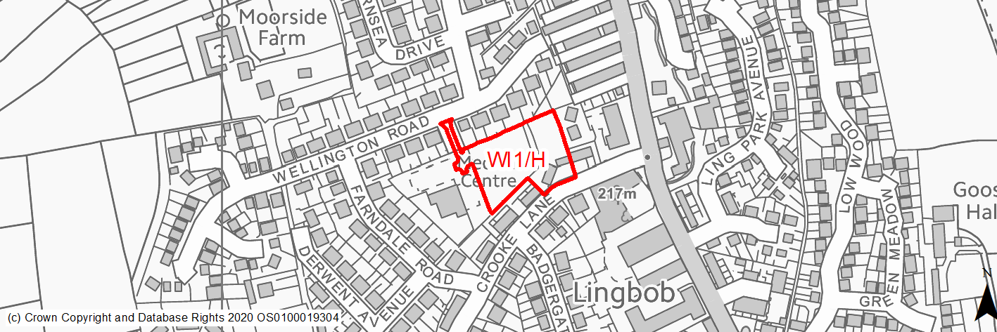
Site location
Local Service Centre - Wilsden
Ward
Bingley Rural Ward
Site description
This is an abandoned development site. Initial work was started on three dwellings but the rest of the site remains undeveloped. It is a relatively level site which has now become overgrown with vegetation. The site is bounded by the rear gardens of properties on Wellington Road and Crooke Lane, and the pharmacy building and the car park of the medical centre.
Proposed Allocation
Housing
SHLAA referencce
WI/002
Indicative no. dwellings
10
Site area (Gross) (ha)
0.54
Ownership
Private
Delivery timescales
Deliverable (0-5 years)
Type (PDL/Greenfield)
Mixed
Green Belt
No
Flood Zone
Flood Zone 1
Potential site access
There is an existing access point into the site off Ling Bob Court.
Public Transport Accessibility
Site is located within 400m of a bus stop with a half hourly service.
Sustainability Appraisal
No significant adverse effects predicted for the site. Minor adverse effects have been predicted for most natural environment themed SA Objectives, given the potential loss of greened over PDL land and greenfield, which includes GI elements. Site is partially within the Wilsden Conservation Area, although the effects of development at the site on the setting of this historic area, as with the potential effects on local townscape character, are dependent on implementation and made somewhat uncertain by the partially developed nature of the site – there could be opportunities to deliver improvements to setting and character.
The site would provide residents with good access to key services and amenities, including jobs, shops, buses and schools, with particularly good access to health facilities (Wilsden Medical Practice is adjacent to the site).
Habitats Regulations Assessment
This site falls within 7km of the South Pennine Moors SPA/SAC. A HRA must be undertaken to ensure there are no significant effects on these protected sites. Developments within these zones must comply with Policy SP11; a SPD is being produced to provide further guidance.
Green Belt
N/A – Site not within the Green Belt.
Constraints and Opportunities
• This is a partially developed, but abandoned site which requires redevelopment.
• Potential impact on the Wilsden Conservation Area which transects the site.
• Consideration of potential ecology present on site.
• The site is located within the 7km buffer of the SPA/SAC.
Development considerations
• A sensitively designed scheme which reflects the existing built form and mitigates any impact on the hertiage assets (Wilsden Conservation Area) which transects the site.
• Ecological survey required to establish status of the site.
• Vehicular and pedestrian access is available off Ling Bob Court.
Conclusion/Summary
This is a small, sustainable site located within the existing settlement. It is located close to a number of services including a GP surgery, shops and other local facilities. It would deliver an estimated 10 dwellings and see the improvement of this abandoned site.
(58) WI2/H - Crack Lane
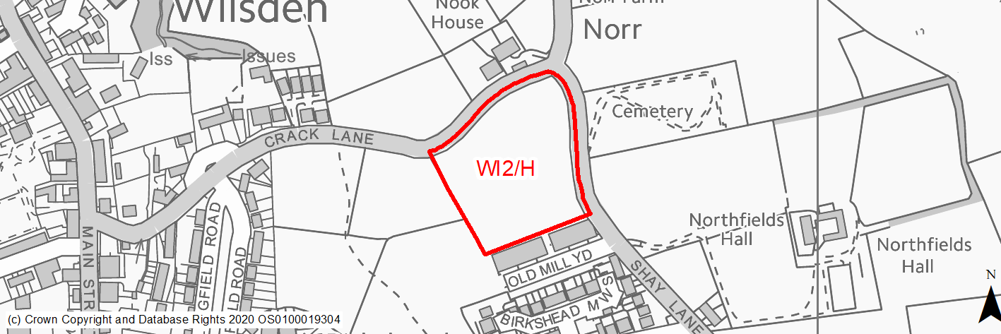
Site location
Local Service Centre - Wilsden
Ward
Bingley Rural Ward
Site description
This is an agricultural field which slopes gently downhill from East to West with some undulations. The site is bounded by dry stone walls on all four sides. Crack Lane forms the northern boundary and Shay Lane forms the eastern boundary. The site adjoins the settlement of Wilsden on two sides (West and South) and is adjacent to residential and industrial development.
Proposed Allocation
Housing
SHLAA referencce
WI/005B
Indicative no. dwellings
40
Site area (Gross) (ha)
1.47
Ownership
Private
Delivery timescales
Developable (6-10 years)
Type (PDL/Greenfield)
Greenfield
Green Belt
Yes
Flood Zone
Flood Zone 1
Potential site access
A new access point will need to be created off either Crack Lane or Shay Lane. Both these roads are narrow and would require improvements.
Public Transport Accessibility
Site is located over 400m from a bus stop with a half hourly service.
Sustainability Appraisal
The site could deliver a major positive effect for residents on the health SA Objective as a result of being within the target distances for all necessary health facilities.
A major adverse effect arises for the climate change resilience SA Objective due to an area at high risk of surface water flooding in the north-eastern portion of the site. Given the number of dwellings proposed for the site, it is unclear whether this could be entirely avoided through a careful layout of the development.
Minor positive effects were predicted for nearly all socio-economic themed SA Objectives due to the benefits of new residential development for the local economy as well as the location of the site in relation to education facilities, local services and amenities, and employment areas. However, access to transport links is somewhat limited.
Minor adverse effects were predicted for a range of natural environment themed SA Objectives, primarily as a result of the impacts of new development on a 100% greenfield and Green Belt site. There are two Grade II Listed Buildings 220m north, and development at this open greenfield site could potentially adversely affect the setting of these sensitive heritage assets.
Habitats Regulations Assessment
This site falls within 7km of the South Pennine Moors SPA/SAC. A HRA must be undertaken to ensure there are no significant effects on these protected sites. Developments within these zones must comply with Policy SP11; a SPD is being produced to provide further guidance.
Green Belt
Based on planning judgement the site has a moderate potential impact on the Green Belt.
• The site is located in a moderate Green Belt parcel.
• The site makes a moderate contribution to the purposes of including land in the Green Belt.
• The site has a low potential for sprawl but would have a major impact on openness.
• The site presents the opportunity to create a new strong, defensible boundary.
Constraints and Opportunities
• The site is currently designated as Green Belt, and the site specific Green Belt assessment indicates that it has a moderate potential impact.
• There are some small areas of potential surface water flooding; Former mining activities on parts of the site have been identified.
• Moderate levels of impact on landscape character and the wider historic environment
• The site is located within the 7km buffer of the SPA/SAC.
Development considerations
• Provision of compensatory improvements to the surrounding Green Belt which may include enhancement of the existing rights of way adjacent to the site.
• Further detailed assessment of the impact of development on the landscape and heritage assets leading to a senstively designed scheme which takes account of the surrounding character.
• Site investigation required for coal mining and surface water flooding risks.
• New vehicular access to be created off Crack Lane/Shay Lane with consideration of pedestrian connections/linkages to the centre of Wilsden.
Conclusion/Summary
This is a sustainable site located adjacent to the settlement boundary and within reasonably close proximity to a number of services including local shops and other community facilities. It would deliver an estimated 40 dwellings and provide a contained suitable extension to the settlement.
(29) WI3/H - Moorside Farm, Wellington Road
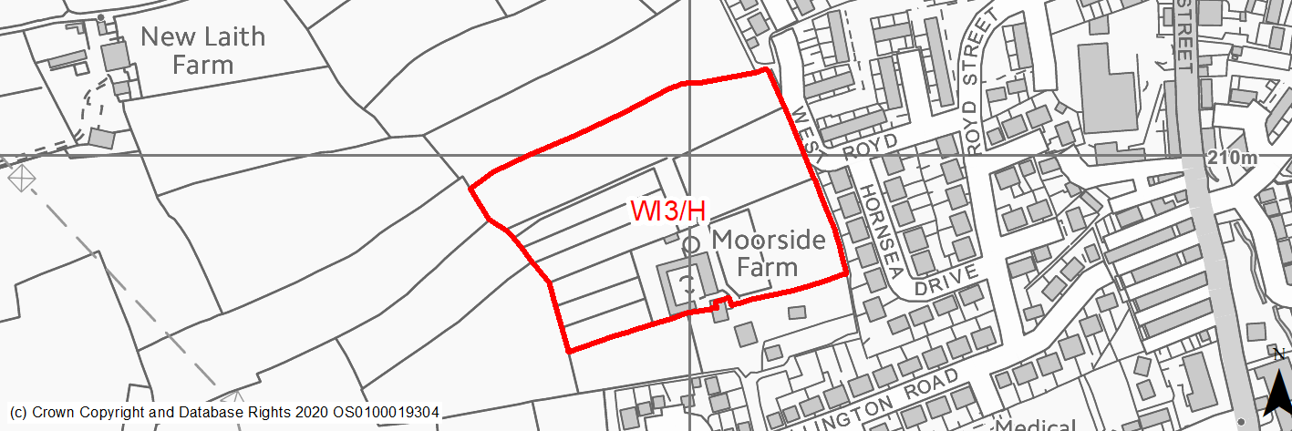
Site location
Local Service Centre - Wilsden
Ward
Bingley Rural Ward
Site description
This site consists of level fields which are used for horses and riding. Access is currently provided from Wellington Road. The site is surrounded by residential development on two sides.
Proposed Allocation
Housing
SHLAA referencce
WI/013
Indicative no. dwellings
80
Site area (Gross) (ha)
3.07
Ownership
Private
Delivery timescales
Developable (6-10 years)
Type (PDL/Greenfield)
Mixed
Green Belt
Yes
Flood Zone
Flood Zone 1
Potential site access
Potential access off Wellington Road at the farm access point - improvements would be requried. Possible new alternative access off West Royd but would require significant works including removal of part of a dry stone wall.
Public Transport Accessibility
Site over 500m of a bus stop with a half hourly service.
Sustainability Appraisal
The site could deliver a major positive effect for residents on the health SA Objective as a result of being within the target distances for all necessary health facilities.
Minor positive effects were predicted for a range of other socio-economic themed SA Objectives due to the benefits of new residential development for the local economy as well as the location of the site in relation to transport links, local services and amenities, and education facilities.
No major adverse effects have been predicted for the site, but minor adverse effects were predicted for a range of natural environment themed SA Objectives, primarily as a result of the impacts of new development on a largely greenfield and Green Belt site. Wilsden Conservation Area is 150m east of the site; there is existing built form between the site and the Conservation Area and so the scope for adverse effects as a result of development is limited, but they should still be considered.
Habitats Regulations Assessment
This site falls within 7km of the South Pennine Moors SPA/SAC. A HRA must be undertaken to ensure there are no significant effects on these protected sites. Developments within these zones must comply with Policy SP11; a SPD is being produced to provide further guidance.
Green Belt
Based on planning judgement the site has a moderate potential impact on the Green Belt.
• The site is located in moderate Green Belt parcel.
• The site makes a low contribution to the purposes of including land in the Green Belt.
• The site has a moderate potential for sprawl and would have a moderate impact on openness.
• There is limited opportunity to create a stronger Green Belt boundary than the existing boundary.
Constraints and Opportunities
• The site is currently designated as Green Belt, and the site specific Green Belt assessment indicates that it has a moderate potential impact.
• Part of the site is previously developed and presents a redevelopment opportunity.
• Access improvements into the site would be required.
• Potential moderate landscape and heritage impacts.
• The site is located within the 7km buffer of the SPA/SAC.
Development considerations
• Provision of compensatory improvements to the surrounding Green Belt which may include enhancement of the existing rights of way adjacent to the site.
• Further detailed assessment of the impact of development on the landscape and heritage assets leading to a senstively designed scheme which takes account of the surrounding character.
• New vehicular and pedestrian access required (off Wellington Road and West Royd).
• Ecological survey to establish status of the site.
Conclusion/Summary
This is a sustainable site located adjacent to the settlement boundary and within reasonably close proximity to a number of services including local shops and other community facilities. It would deliver an estimated 80 dwellings and provide a moderate-sized extension to the village helping to sustain local services.