
Draft Bradford District Local Plan - Preferred Options (Regulation 18) February 2021
Shipley
Introduction
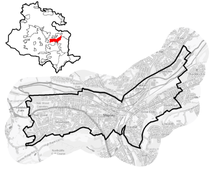
5.7.1 Shipley is located approximately 5km to the North of Bradford city centre on the A650, the main transport route connecting Keighley to Bradford. The area forms part of the northern fringes of the Bradford urban area. Shipley is a mixed area with large residential suburbs, employment and retail areas with an important town centre. It has superb rail connectivity offering short journey times from Shipley Station to Bradford City Centre and Leeds and onward rail connections to London.
5.7.2 The town centre is the focal point for the provision of shopping, leisure and public services, which caters for local needs. Within close proximity to the town centre is the World Heritage Site of Saltaire and significant employment areas, including am industrial and office cluster around Dockfield Road. Salt's Mill, the focal point of Saltaire, is a fantastic example of the area's architectural heritage and there are clusters of attractive historic buildings around the fringes of the town centre and the Leeds and Liverpool Canal.
5.7.3 Shipley is part of the Regional City of Bradford with retail and leisure functions located within and around the town centre. The area has excellent rail and bus connections with Bradford and Leeds. Shipley has its own Parliamentary Constituency and falls within the Shipley, Baildon Ward and Windhill and Wrose wards.
5.7.4 The settlement area has a population of 18,626 residents with 64.5 % falling within the working age category (16-64), similar to the West Yorkshire (62.8%) and England (62.4%) averages. The ethnic composition of Shipley is primarily made up of people who identify themselves as White British (82.5%). This is a higher proportion than the West Yorkshire average (78.4%).
Figure 1: Location Plan
Planning for Prosperity
5.7.5 The Local Plan settlement hierarchy identifies Shipley as within the Regional City of Bradford, which is the prime focus for housing, employment, shopping, leisure, education, health and cultural activities and facilities in the District. There is a key focus on transforming its economic, environmental, physical and social conditions to support its long term regeneration. Shipley is also identified by the Local Enterprise Partnership as a Spatial Priory Area (SPA) Investment Location for Regeneration. Linked to this, is Shipley's identification for a Town Investment Plan to transform Shipley's economic growth prospects with support from the government's Towns Fund. The fund will provide up to £25m for Shipley to invest in capital projects designed to improve connectivity, land use, economic and cultural assets, skills and enterprise infrastructure in the town.
5.7.6 The area provides the opportunity to deliver significant housing and economic growth supported by environmental and sustainable transport improvements and to secure direct investment and funding to support the delivery of innovative and sustainable development, skills, culture, climate change mitigation and green infrastructure enhancements.
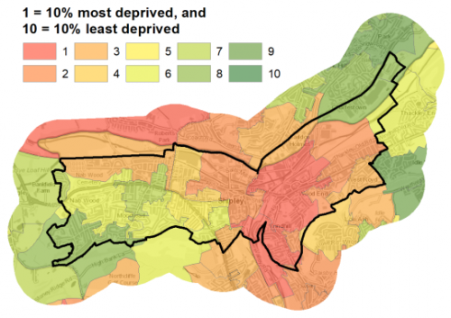
5.7.7 Shipley is a mixed area, with areas of relative affluence located to the south and west and areas of higher deprivation to the north and east. 34.3% of individuals living in Shipley are amongst the 20% most deprived neighbourhoods in England. Shipley ward is the 4th most deprived area in Bradford on a scale of 1 being most deprived and 10 being least deprived.
Figure 2: Index of Multiple Deprivation – Shipley
Economy and Employment
5.7.8 Shipley has historically been, and remains, an area of industry and employment and includes areas that are home to a diverse range of established businesses and employers. The area currently provides significant employment opportunities and is popular with many business sectors. There are a range of local employment opportunities within the area. There is one designated employment area within Shipley. The area is also highly accessible to Bradford and Leeds city centres for access a wider range of employment opportunities.
5.7.9 The economic activity rate at 73.3% is above the West Yorkshire average (68.5%) as are the number of full-time employees. The average income is £40,170 per household, which is higher than the West Yorkshire average of £38,499. There are employment opportunities within the town with the three largest employment sectors focussed around health and social work, education and retail. The three largest industry groups for workforce jobs based in Shipley are health, retail and professional, scientific & technical services.
5.7.10 The main employment area is located around Dockfield Road and North of the railway line. There is also a large Business Development Zone (BDZ) identified in Shipley from Saltaire to Dockfield Road. One specific large employment land allocation is proposed for this area (SH23/E), located South of Carnaud Metalbox Engineering Site. In addition, under Policy SP6 economic growth and investment will continue to be supported particularly with a focus upon the priority sectors of retail, manufacturing and professional services.
Retail
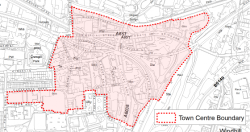
5.7.11 Shipley Town Centre has an important town centre (Figure 3) and has been subject to a review as part of the Retail and Leisure Study (2019). The Primary Shopping Area is concentrated on the Market Square, Kirkgate, Westgate, Manor Lane and Wellcroft and includes the Asda store. This area contains a high proportion of retail units, supported by a range of uses such as cafes, bars and financial and professional services. Outside of this area, there are a number of retail, service and leisure units within the town centre. An outdoor market is located in Market Square on Mondays, Fridays and Saturdays. Shipley also contains a covered market, the Underground Hall, located in between Kirkgate and Westgate.
5.7.12 The Retail and Leisure Study (2019) identified that Shipley maintains a relatively strong position in the District and has a relatively good health, however there are a number of issues which need addressing, including:
- The public realm, requires investment and updating;
- There is a higher than average amount of vacant properties in the centre;
- The Underground Market is not well integrated with the centre, is difficult to locate and is in need of refurbishment;
- The area to the north of the canal and to the east of Otley Road, whilst falling within the defined town centre boundary, are disconnected from the main area as these features act as significant physical barriers;
- Buildings in key areas, or prominent buildings, are in need of maintenance.
In summary, Shipley is considered to be a functional and healthy town centre, and in particular it is recommended that and investment programmes are implemented to improve and update the centre's public realm and buildings. Figure 3 shows the town centre boundary.
Figure 3- Shipley Town Centre
Transport and Access
5.7.13 Lying at the northern end of the Regional City of Bradford, Shipley benefits from a range of excellent transport opportunities within the wider area, which provide excellent links around and beyond the Bradford District. The Airedale Corridor which links Bradford to Shipley and Keighley is a key transport corridor and transport priority for the District. The A650 Bingley Road and the A6037 Valley Road/Canal Road are two major routes into and out of the cityto the north and connect with the M606 and M62 motorways to the south. To the South, Canal Road is a strategic route within the wider Leeds City Region, linking areas within the Bradford District and beyond. The close proximity of the area to these key highway routes provide a range of travel opportunities for the local communities to travel to surrounding areas within the District and major centres outside the District.
5.7.14 Shipley town centre benefits from excellent public transport facilities. Located on the Airedale line Shipley Station is a key transport hub and part of the West Yorkshire Combined Authority (WYCA) Rail Park and Ride programme. The station provides frequent trains to Bradford, Ilkley and Keighley with connectivity further afield to Leeds and beyond.
5.7.15 The area is served by several high-frequency (every 15 to 20 minutes) bus routes with services operated by First Bradford linking to Bradford City Centre, Bingley, Baildon and beyond into Halifax and Huddersfield. 33.8% of all households have no car, compared with 29.4% across West Yorkshire. The value of public transport and good walkable local services is therefore important.
5.7.16 There are a number of Public Rights of Way that run through the area, including the long distance Dales Way link, which connects the area to the wider open countryside to the north and the Leeds and Liverpool Canal. The area also has excellent cycle links. National Cycle Route 66 connects Bradford city centre to Shipley along the Canal Road Corridor, parts of which have been updated through the Canal Road Greenway. The Airedale Greenway passes through the centre of the area, linked by the Leeds and Liverpool Canal towpath.
5.7.17 Strategic transport infrastructure projects to be delivered within the plan period and protected routes are set out on the Policies Map with the local plan. Key initiatives within the Shipley are detailed in Table 1 below.
Table 1: Shipley Transport Projects
|
Policies Map Ref. |
Project Name |
|
TR1.E.1 |
Bradford Shipley Route Improvement Scheme |
|
TR1.B.2 |
Shipley Parking Extension |
|
TR1.C.1 |
Bus Priority Corridor (Bradford to Keighley and Shipley to Thackley) |
|
TR1.A.5 |
Airedale and Canal Road Greenway (Canal route) |
|
TR1.A.6 |
Bradford Canal (Route of) |
5.7.18 In relation to digital connectivity, average broadband download speeds in Shipley is 50.09 megabytes per second – above the West Yorkshire average (44.57).
Planning for Homes
5.7.19 There are 6,703 dwellings within the settlement area. Three fifths are owner occupied (59.2%), which is lower than the West Yorkshire average (63.4%). 15.4% are socially rented and 22.4% of properties are private rented, which is higher than regional and national average.
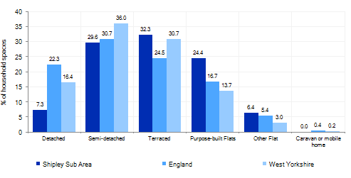
5.7.20 The area has a varied mix of house types ranging from older terraced properties accounting for 32.3% and purpose built flats (24.4%), with fewer detached (7.3%) and semi-detached houses (29.6%) than the regional average. Figure 4 below provides further information.
Figure 4: Shipley – Dwelling Type Breakdown
5.7.21 Average house prices in the area are £151,676, which is lower than the than the West Yorkshire average of just over £183,000. The total affordability ratio between house prices and annual earnings which is usually used as a proxy for number of years' worth of earnings required for a house deposit is 3.36 compared to a West Yorkshire average of 2.96.
5.7.22 Delivering new housing, is a key part of the overall development strategy for Shipley. The Local Plan seeks to support the creation of sustainable communities in Shipley through the regeneration of existing urban areas, particularly supporting the economic, environmental, physical and social regeneration of key areas including: The Town Centre, Dockfield Road, land East of the Station at Crag Road, the re-cycling of brownfield land and the expansion of the urban area in sustainable locations to the West. It will ensure that the housing needs and aspirations of local people can be met, together with those of future residents, including market and affordable housing. In addition, it will support the economic and regeneration aspirations for the wider area, as well as reflecting its role as a sustainably connected part of the Regional City of Bradford and a regeneration and investment location.
5.7.23 Policy SP8 in the local plan sets out a minimum requirement of 1,200 dwellings to be delivered during the plan period. These will be delivered through a mix of committed sites (those under construction or have planning permission but have not yet commenced) and site allocations. Table 2 below, sets out the housing position for Shipley, which also includes the application of non-implementation or discount rates for planning permissions and allocations. The Council will be supportive of additional proposals for new homes on additional small sites, particularly those that provide a redevelopment opportunity to bring forward land which has been previously used. Support will also be provided to developers who wish to redevelop larger sites and/or buildings for new homes not currently identified, subject to all relevant policies in the Local Plan.
Table 2: Shipley - Summary of Housing Requirement and Supply
|
Housing Target |
1,200 units |
|
Carried Forward Commitments |
32 |
|
Commitment Discounted by 10% |
29 |
|
Remaining Allocation Requirement |
1,171 |
|
Identified Allocations |
1,322 |
|
Allocations Discounted by 10% |
1,189 |
|
Total Supply Contribution from Allocations |
1,189 |
5.7.24 Once the commitments are discounted and removed from the supply this leaves a residual allocation requirement of 1,171 units. The evaluated total site supply of housing units from preferred allocation sites equates to, 1,322 units which is in turn discounted by 10% for non-implementation or reduced delivery, leaving a final allocation contribution of 1,189 units across all sites, which is slightly above the remaining allocation requirement (1,171 units) but is reflective of site yield of the identified sites.
5.7.25 The area is constrained by Green Belt with brownfield and greenfield growth options available and identified. Shipley's allocation mix of 21 sites includes 13 sites which are brownfield and 1 which is mixed (brownfield and greenfield). The remainder are greenfield sites; 4 are within the urban area, whilst 3 fall within the current Green Belt. The Local Plan preferred site allocations for residential allocations to meet the Shipley housing requirement are set out in Table A and identified on the Policies Map and the Site Pro Formas below together with the local strategies map for each plan area. Development of site allocations should be in accordance with specified development guidelines and approximate site provision figures and all other relevant policies of this Local Plan. In delivering the target for new homes in Shipley it has been necessary to make some changes to the adopted Green Belt. Policy SP5 sets out the Council's approach and justification for green belt releases to accommodate new development and lists the sites proposed for allocation which current lie within or partly within the Green Belt.
Planning for Places and Communities
Green Belt, Natural Landscape and Historic Character
5.7.26 Shipley is characterised by an urban landscape along an industrial corridor divided by established parks and less formal urban greenspaces out to a rural landscape, which frames the area on the Western and Northern boundaries. This rural land lies within the Bradford Green Belt and the Airedale Landscape Character Area. The landscape as a whole has been assessed as being moderately, sensitive in character. The prevailing landscape in this area is characterised by a mixture of woodlands, upland pasture, gritstone moorland, industrial corridor and floodplain pasture. The Leeds and Liverpool Canal is an important feature within the Shipley corridor.
5.7.27 Shipley is focussed around major transport corridors, which has a busy feel. Shipley's heritage reflects that of a former industrial and employment area, set against a rural backdrop. The area includes and is adjacent to a number of important heritage assets, including a number of Conservation Areas, historic parks and listed buildings and contains waterways, buildings, and structures that contribute to the area's local character and historic interest. Of international, national and local importance to the District is Sir Titus Salt's model village of Saltaire, which is one of only two UNESCO World Heritage Sites in Yorkshire.
5.7.28 There are three Conservation Areas within the area – Saltaire, Baildon Green and the Leeds and Liverpool Canal. There are a total of 853 Grade II and 6 Grade II* Listed Buildings within the area. The area includes the Saltaire World Heritage Site and its Buffer Zone.
5.7.29 The former Bradford Canal previously ran for 3 miles through the area from the Leeds and Liverpool Canal at Shipley to the centre of Bradford. The Bradford Canal closed to navigation in 1922.The re-introduction of the Bradford Canal has been a long term ambition for the Council. The reopening of the Bradford canal is not considered economically feasible over the short to medium term. However, the plan includes provision to safeguard an alignment for proposed re-introduction of the Bradford Canal to enable its future provision.
Green Infrastructure, Ecology, Open Space and Flood Risk
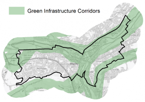
5.7.30 Shipley is part of a key Green Infrastructure (GI) Corridor for the District and wider region and has a range of areas and spaces that contribute towards its Green and Blue Infrastructure. The River Aire and Leeds and Liverpool Canal form an important blue/green corridor and habitat network running through the heart of the area West to East. Other key Green and blue corridors, include through Shipley Glen to Baildon Moor to the North, along the Bradford Beck, South around Northcliffe Park and West towards Cottingley and Bingley. The main GI corridors are detailed below in Figure 5.
Figure 5: Green Infrastructure Corridors
5.7.31 The area lies within 7000m of the South Pennine Moors Special Protection Area (SPA) and has a range of local wildlife sites and ecologically important habitatsnetworks. The Leeds- Liverpool Canal is a Site of Ecological or Geological Importance (SEGI). The River Aire is an important corridor with potential to link habitats. It is the focus of the Leeds City Regions 'Fresh Aire' initiative and the Wildlife Trust's Aire Valley Living Landscape projects, both projects highlighting the river corridor in the context of wildlife and Green Infrastructure. Additional ecological assets include the natural assets of Walker/Midgley Woods, Hirst Wood, Nab Wood, and Old Spring Wood ancient woodlands. The Bradford Beck is also a key local waterway with aspirations for its ecological improvement and re-naturalisation.
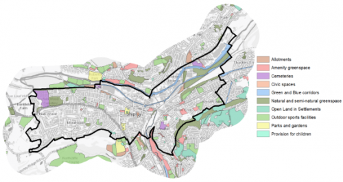
5.7.32 In regards to formal open space, thereare 80 sitesidentified as open space covering an area of 99.21ha. The key sites within the area are:
- Roberts Park
- Northcliffe Park
- Nab Wood Cemetery
- Saltaire Sports Ground
- Northcliffe Golf Course
- Leeds and Liverpool Canal
- River Aire
5.7.33 There is a good level of provision of certain types of open space in Shipley (Allotments, Cemeteries, Green and Blue Corridors, Natural and Semi-natural Greenspace and Provision for Children) but some deficits of other typologies. Of particular note is in Outdoor Sports and of Parks and Gardens despite the well-used Roberts Park and Northcliffe Park. Future opportunities for Outdoor Sports and Parks and Gardens should therefore be the priority for additional provision where the opportunities arise. Figure 6 shows the location of existing areas if open space.
Figure 6: Shipley - Open Space Overview
5.7.34 Shipley's location means that parts of area along the valley floor are at high risk of river flooding from the River Aire the Bradford Beck. In particular areas adjacent the River Aire around Roberts Park, Dockfield Road and West of Otley Road is identified as being in Flood Zone 3 and 3b
Community Infrastructure – Education, Health and Utilities
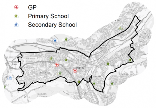
5.7.35 Shipley has a local civic role and has a wide range of community facilities to meet the day to day needs of its local residents. These facilities include a Town Hall, schools, GP surgeries, post offices, places of worship, community halls/centres, playgrounds, a library, swimming pool and various sporting facilities. The area is served by 7 primary schools and a number of secondary school with Dixons Cottingley Academy and Titus Salt School being the nearest Secondary schools to the area. Pupils attainment levels at Key Stage 4 (GCSE) is above the West Yorkshire and national (England) average scores – 391.9 compare to 353.5 and 366.3 respectively. Shipley has a number of NHS registered healthcare facilities within the area. Secondary (acute) healthcare is provided at Bradford Royal Infirmary. Figure 7 shows the location of local schools and medical facilities.
5.7.36 Average life expectancy at birth for Shipley residents is similar to the West Yorkshire and England average, with healthy life expectancy of 61 for men and 63 women.
Figure 7: Schools & Medical Facilities in Shipley
5.7.37 There is one existing waste management facility within in the area, the Crossley Evans site located to the south of Shipley town centre. The Crossley Evans site is one of the three major metal recovery sites (MRS) located within the District. This site is also an important part of the District's waste management infrastructure, as a large established waste site within a central urban area with good connectivity to the primary road and rail network.
5.7.38 When planning for the long-term development of Shipley, it is vital that new development is supported by the appropriate infrastructure. The capacity, quality and accessibility of services and facilities are all key components in ensuring people can enjoy living, working and visiting the area. The Council will continue work with key infrastructure providers and others including the Local Education Authority, Clinical Commissioning Group and utilities providers to determine the impacts of future growth and development on local infrastructure capacity and provision. Further infrastructure details will be published through the Local Infrastructure Plan and as part of the
|
Local Area Strategy and Plan- Shipley The Local area strategy for Shipley includes:
|

(40) Consultation Question 96
Shipley Local Area Strategy
The Local Plan sets out a local area strategy for Shipley.
Q. Please provide any comments you may have on the area strategy?
If you have an alternative to the approaches undertaken, please provide further details and evidence in support.
Preferred Site Allocations and Site Pro Formas
5.7.39 The preferred housing site allocations are detailed below in Table A. This table is followed by site pro formas for each preferred site allocation proving a summary of key site information and characteristics.
Table A: Shipley: Housing - Preferred Allocations
|
Site Ref |
Site Name |
Dwellings / Other Uses |
|
SH1/H |
East Victoria Street |
27 |
|
SH2/H |
Carr Lane |
51 |
|
SH3/H |
Wycliffe Road |
44 |
|
SH4/H |
Glenview Drive, Bankfield Road, Nabwood, Shipley |
164 |
|
SH5/H |
Bingley Road, Nabwood |
140 |
|
SH6/H |
Bankfield Farm, Nabwood |
49 |
|
SH7/H |
Queens Road/Ferncliffe Road - Saltaire |
30 |
|
SH8/H |
The Old School Building - Wrose Brow Road |
10 |
|
SH9/H |
Shipley Tax Office, Shipley |
266 |
|
SH10/H |
Dockfield Road North/Dockfield Road South |
50 (mixed use) |
|
SH11/H |
Land around Crag Road Flats |
30 |
|
SH12/H |
Crag Road |
78 |
|
SH13/H |
Regent House |
93 |
|
SH14/H |
Shipley Market Hall |
20 |
|
SH15/H |
Buildings along Briggate |
20 |
|
SH16/H |
Market Square |
25 |
|
SH17/H |
Shipley Gateway Site |
50 |
|
SH19/H |
Land between Leeds Road and Dock Lane |
60 |
|
SH20/H |
Station Road |
50 |
|
SH21/H |
Wrose Brow Road, Windhill |
50 |
|
SH22/H |
Browfoot/Wrose Brow Road |
15 |
|
Total |
1322 |
(36) Consultation Question 97
Shipley Site Allocations and Site Pro Formas
The Local Plan sets out a series of preferred site allocations. If you wish to make representations on any of the sites proposed, please provide site reference and feedback under this question. If you wish to propose an additional or alternative site(s) to the preferred allocations listed, please also provide a plan with a red line and any further details in support.
(18) SH1/H - East Victoria Street
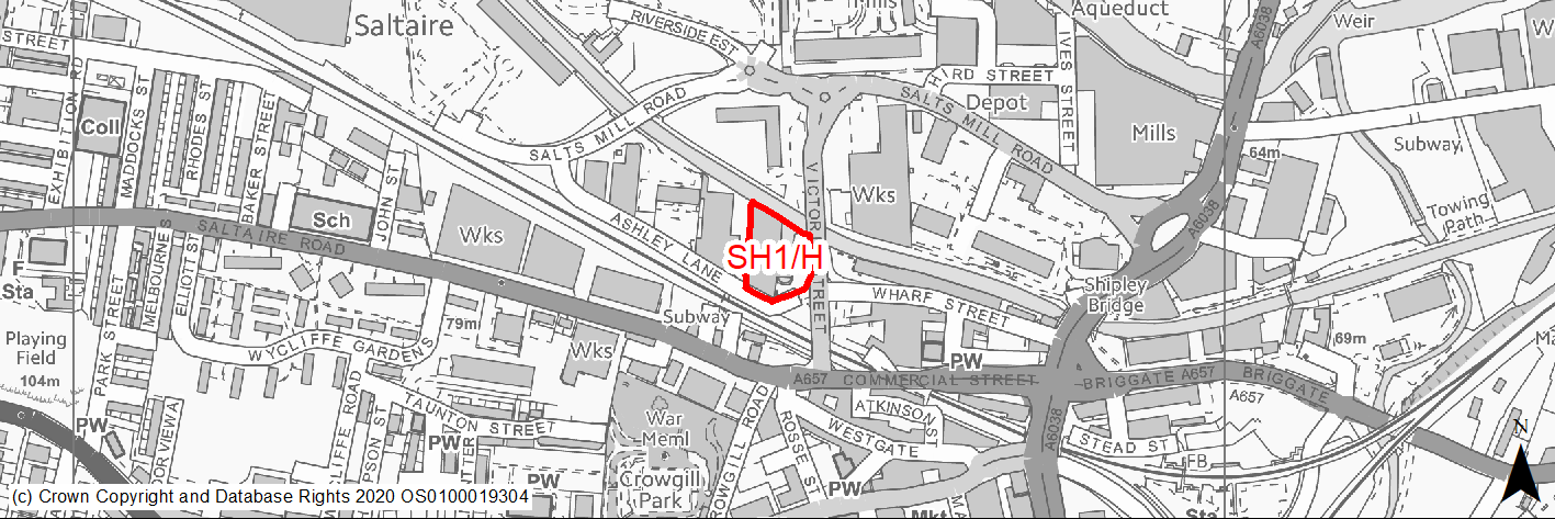
Site location
Regional City of Bradford- Shipley
Ward
Shipley Ward
Site description
The site consists of part vacant former canal warehouse building set around a canal basin. There is an informal vacant grassed area to the East of the site directly adjacent to Victoria Street.
Proposed Allocation
Housing
SHLAA referencce
SH/014
Indicative no. dwellings
27
Site area (Gross) (ha)
0.36
Ownership
Private
Delivery timescales
Developable (6-11 years)
Type (PDL/Greenfield)
PDL
Green Belt
No
Flood Zone
Flood Zone 1
Potential site access
Access to the site is available via Ashley Lane. However, this road is narrow and will require improvement. Victoria Street has cycle and pedestrian access, however direct access for vehicles is unlikely to be acceptable.
Public Transport Accessibility
Site within 400m of a bus stop and 800m of nearest rail station (Shipley).
Sustainability Appraisal
A significant adverse effect has been predicted for the water resources SA Objective, as a result of the Leeds and Liverpool Canal being within the site perimeter. Development at the site could potentially pose a risk to water quality. A significant adverse effect has also been predicted for the air quality SA Objective as a result of the site being within the CAZ. No other significant adverse effects have been predicted.
The site is within the buffer zone for the Saltaire WHS and so the potential impacts on this highly sensitive and valuable heritage asset and historic area would require careful consideration as part of any planning application at the site. The site is also located within the Leeds-Liverpool Canal Conservation Area.
The site is well located to provide residents with good access to shops, jobs, cultural spaces, and schools, with particularly good access to public transport and health facilities.
Habitats Regulations Assessment
This site falls within 7km of the South Pennine Moors SPA/SAC. A HRA must be undertaken to ensure there are no significant effects on these protected sites. Developments within these zones must comply with Policy SP11; a SPD is being produced to provide further guidance.
Green Belt
N/A – Site not within the Green Belt.
Constraints and Opportunities
• Site is within WHS Buffer Zone, within 50m of a Grade II listed building (Shipley Wharf) and the Leeds Liverpool Canal Conservation Area. The site is on a Critical Approach and gateway to Saltaire World Heritage Site.
• Important Urban Landscape site, site design should reflect previous use and canal side character.
• Opportunity to open up view of all 3 chimneys.
• Site adjacent local wildlife network and GI Corridor (Leeds Liverpool Canal). Opportunities for additional habitats would be sought.
Development considerations
• Site is suitable for higher density development through conversion and retention of existing historic building and features.
• Sensitive site design to mitigate any impact on the conservation area/WHS and setting of listed building.
• Ecological appraisal and Heritage Statement required to identify any impacts and mitigate accordingly.
Conclusion/Summary
This is a sustainably located brownfield site within the settlement boundary, which would deliver an estimated 27 dwellings.
(9) SH2/H - Carr Lane
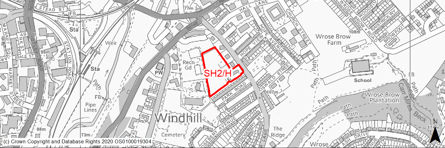
Site location
Regional City of Bradford- Shipley
Ward
Windhill and Wrose Ward
Site description
The site is located between the rear of Park Road and Crag Road and slopes down towards Crag Road in a South-North direction. The site consists of a large area of vacant previously developed land. There is an area of open space to the north behind the car park to retail units on Crag Road and an in use Funeral Directors and residential uses to the south of the site. The site has partly revegatated with some mature trees/shrubs within the site.
Proposed Allocation
Housing
SHLAA referencce
SH/019
Indicative no. dwellings
51
Site area (Gross) (ha)
0.92
Ownership
Private
Delivery timescales
Developable (6-11 years)
Type (PDL/Greenfield)
PDL
Green Belt
No
Flood Zone
Flood Zone 1
Potential site access
Access to the site is available from existing access on Carr Lane. However, this access is narrow and would need improvement. Access from the back of Crag Road is unlikely to be suitable.
Public Transport Accessibility
Site within 400m of a bus stop (Leeds Road) and 800m of nearest rail station (Shipley).
Sustainability Appraisal
No significant adverse effects predicted for the site. Minor adverse effects predicted for most natural environment themed SA Objectives, primarily as a result of the effects associated with development on greenfield. The site is well located to provide residents with good access to jobs, shops, cultural spaces, buses, and schools, with particularly good access to health facilities.
Habitats Regulations Assessment
This site falls within 7km of the South Pennine Moors SPA/SAC. A HRA must be undertaken to ensure there are no significant effects on these protected sites. Developments within these zones must comply with Policy SP11; a SPD is being produced to provide further guidance.
Green Belt
N/A – Site not within the Green Belt.
Constraints and Opportunities
• Site is in WHS Buffer Zone, potential impact on important views.
• Mainly brownfield site revegetated in part with mature trees. Potential non native species.
• Topography - site steeply sloping in parts.
• Narrow constrained vehicular access onto busy road (Carr Lane).
• Site adjacent open space (Windhill Recreation Ground).
Development considerations
• High quality design, scale, form, materials, landscaping, boundary treatment.
• Ecological survey and Heritage Statement required to identify any impacts and mitigate accordingly.
Conclusion/Summary
This is a sustainably located brownfield site within the settlement boundary, which would deliver an estimated 51 dwellings.
(337) SH3/H - Wycliffe Road
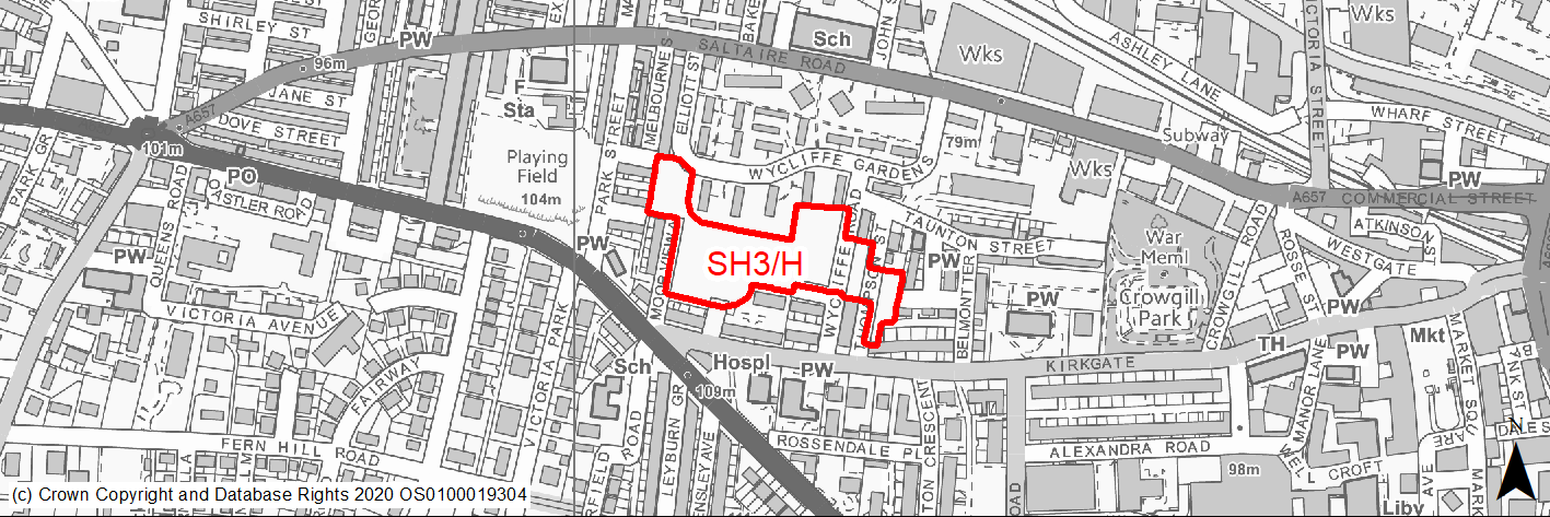
Site location
Regional City of Bradford- Shipley
Ward
Shipley Ward
Site description
The site consists of three areas of open space separated by Wycliffe Road and Thompson Street. The land is adjacent to the blocks of two/three storey flats around Wycliffe Gardens to the North. The site slopes down in a south- north direction and has views of Salts Mill to the north. There are residential uses to the west, south and east.
Proposed Allocation
Housing
SHLAA referencce
SH/022
Indicative no. dwellings
44
Site area (Gross) (ha)
1.38
Ownership
Private
Delivery timescales
Deliverable (0-5 years)
Type (PDL/Greenfield)
Greenfield
Green Belt
No
Flood Zone
Flood Zone 1
Potential site access
Access to the site is available from the existing roads around the site, which may require improvement.
Public Transport Accessibility
Site within 400m of a bus stop (Bingley Road/Saltaire Road) and 800m of nearest rail station (Saltaire).
Sustainability Appraisal
Potential negative effects on natural environment associated with development on greenfield. Primarily positive effects predicted for socio-economic objectives. Excellent access to transport and health facilities.
Habitats Regulations Assessment
This site falls within 7km of the South Pennine Moors SPA/SAC. A HRA must be undertaken to ensure there are no significant effects on these protected sites. Developments within these zones must comply with Policy SP11; a SPD is being produced to provide further guidance.
Green Belt
N/A – Site not within the Green Belt.
Constraints and Opportunities
• Site is in WHS Buffer Zone, potential impact on important views to Salts Mill.
• Topography. Parts of site steeply sloping.
• Opportunities to rationalise and create new areas of publically accessible open green space within the site.
• Site comprised of large area of existing informal amenity open space in a densely developed area.
• Part of the site former landfill.
Development considerations
• High quality design, scale, form, materials, landscaping, boundary treatment.
• Heritage Statement required to identify any impacts and mitigate accordingly.
Conclusion/Summary
This is a sustainably located site within the settlement boundary, which would deliver an estimated 44 dwellings.
(337) SH4/H - Glenview Drive, Bankfield Road, Nabwood
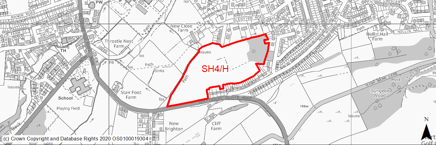
Site location
Regional City of Bradford- Shipley
Ward
Shipley Ward
Site description
The site consist of a large undulating open field which is steeply sloping in parts, with areas of mature trees and woodland within the site. The site is located between residential areas around Gelnview Drive to the North and Cottingley Cliffe Road to the South with open fields to the West.
Proposed Allocation
Housing
SHLAA referencce
SH/026
Indicative no. dwellings
164
Site area (Gross) (ha)
6.23
Ownership
Private
Delivery timescales
Developable (6-11 years)
Type (PDL/Greenfield)
Greenfield
Green Belt
Yes
Flood Zone
Flood Zone 1
Potential site access
Access to the site is available from Glenview Drive via Glenview Road. Direct access from Cottingley Road is unlikely to be suitable.
Public Transport Accessibility
Site within 400m of a bus stop (Bingley Road/Saltaire Road) and beyond 800m of nearest rail station (Saltaire).
Sustainability Appraisal
The site could deliver a major positive effect for residents on the education SA Objective as a result of being within the target distance for both primary and secondary education facilities.
A significant adverse effect has been predicted for the air quality SA Objective as a result of the site being situated entirely within the CAZ. Development here could potentially make achieving air quality improvement targets within the CAZ more difficult.
Minor positive effects were predicted for most socio-economic themed SA Objectives due to the benefits of new residential development for the local economy as well as the location of the site in relation to transport links, health facilities and employment areas, although residents would likely be required to travel beyond the target distance to access services and amenities.
As a large greenfield and Green Belt site with deciduous woodland priority habitat dominating the eastern portion, development here has been predicted to result in minor adverse effects on most natural environment themed SA Objectives. Two small, unnamed surface waterbodies are adjacent to the site boundary and a number of other small waterbodies are within 100m; the development could pose a risk to water quality.
A Grade II and a Grade II* Listed Building are within 40m of the site, the settings of which could be adversely affected by the development.
Habitats Regulations Assessment
This site falls within 7km of the South Pennine Moors SPA/SAC. A HRA must be undertaken to ensure there are no significant effects on these protected sites. Developments within these zones must comply with Policy SP11; a SPD is being produced to provide further guidance.
Green Belt
See individual Green Belt site assessment in the accompanying report.
Constraints and Opportunities
• Impact on landscape character, including loss of open land prominent from Cottingley Road.
• Large area of priority woodland within site and the remainder of the site may be valuable and other priority habitats may be present.
• New tree planting along the west and northern boundary could improve wildlife links and screen a smaller development from longer views and footpath receptors to the west.
• PROW along western boundary of the site.
Development considerations
• New strong defensible Green Belt boundary to west of site and Compensatory Green Belt enhancement required.
• Development to protect existing priority woodland, trees and hedgerows within site and increase tree cover.
• Development to proivde new high quality pedestrian and cycle routes through the site and connect to exisitng PROW network to the West.
• Full Ecological surveys and landscape assessment required to identify any impacts and mitigate accordingly.
• Sensitive site design to mitigate any impact on landscape character.
Conclusion/Summary
This is a sustainably located green belt site, which would deliver an estimated 164 dwellings.
(292) SH5/H - Bingley Road, Nabwood
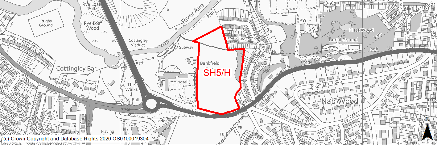
Site location
Regional City of Bradford- Shipley
Ward
Shipley Ward
Site description
The site consists of two large mainly level open pasture fields adjacent to the West of the settlement with mature trees along the boundaries. The site is located between Branksome Drive and the Mecure hotel to the West and is bordered by Bradford Road to the South. There is an existing small agricultural stable to the south east corner of the site. There are residential uses to the East and open fields tand River Aire to the North.
Proposed Allocation
Housing
SHLAA referencce
SH/027
Indicative no. dwellings
140
Site area (Gross) (ha)
5.31
Ownership
Private
Delivery timescales
Developable (6-11 years)
Type (PDL/Greenfield)
Greenfield
Green Belt
Yes
Flood Zone
Flood Zone 1. Small areas of zone 2 to north of site.
Potential site access
Access to the site is available via the existing access on Bradford Road, which will need improvement. Direct vehicle access from Branksome Grove is unlikely to be acceptable for the whole site.
Public Transport Accessibility
Site within 400m of a bus stop (Bingley Road) and beyond 800m of nearest rail station (Saltaire).
Sustainability Appraisal
A significant adverse effect has been predicted for the air quality SA Objective as a result of the site being situated largely within the CAZ. Development here could potentially make achieving air quality improvement targets within the CAZ more difficult.
Minor positive effects were predicted for most socio-economic themed SA Objectives due to the benefits of new residential development for the local economy as well as the location of the site in relation to transport links and health and education facilities, although residents may need to travel beyond the target distance to access services and amenities.
Minor adverse effects were predicted for a range of natural environment themed SA Objectives, primarily as a result of the impacts of new development on a 100% greenfield site containing trees. The site is approximately 45m south of the River Aire at its closest point, and this may be impacted by the construction and occupation of this site.
The site falls within the buffer zone for the Saltaire WHS, which may require consideration as part of any planning application.
Habitats Regulations Assessment
This site falls within 7km of the South Pennine Moors SPA/SAC. A HRA must be undertaken to ensure there are no significant effects on these protected sites. Developments within these zones must comply with Policy SP11; a SPD is being produced to provide further guidance.
Green Belt
See individual Green Belt site assessment in the accompanying report.
Constraints and Opportunities
• Site is in WHS Buffer Zone.
• Impact on landscape character. The site is one of the last areas of open landscape buffer between Shipley and Cottingley.
• Impact on views from footpath receptors leading to and adjacent to the River Aire.
• Flood risk - part of the site to the north is within flood zone 2 and small areas of higher surface water flood risk.
• GI corridor, PROW and local habitat network to north of the site and TPO woodland along site boundary to the South.
Development considerations
• Full Ecological surveys and landscape assessment required to identify any impacts and mitigate accordingly.
• Buffers to existing woodland, hedgerows and waterways required.
• Development to protect and incorporate existing trees/hedgerows within site and increase the tree cover.
• Compensatory Green Belt enhancement required.
• Retain and enhance GI links, habitat networks and PROW to north of the site.
Conclusion/Summary
This is a sustainably located green belt site adjoining the settlement boundary, which would deliver an estimated 140 dwellings.
(207) SH6/H - Bankfield Farm, Nabwood
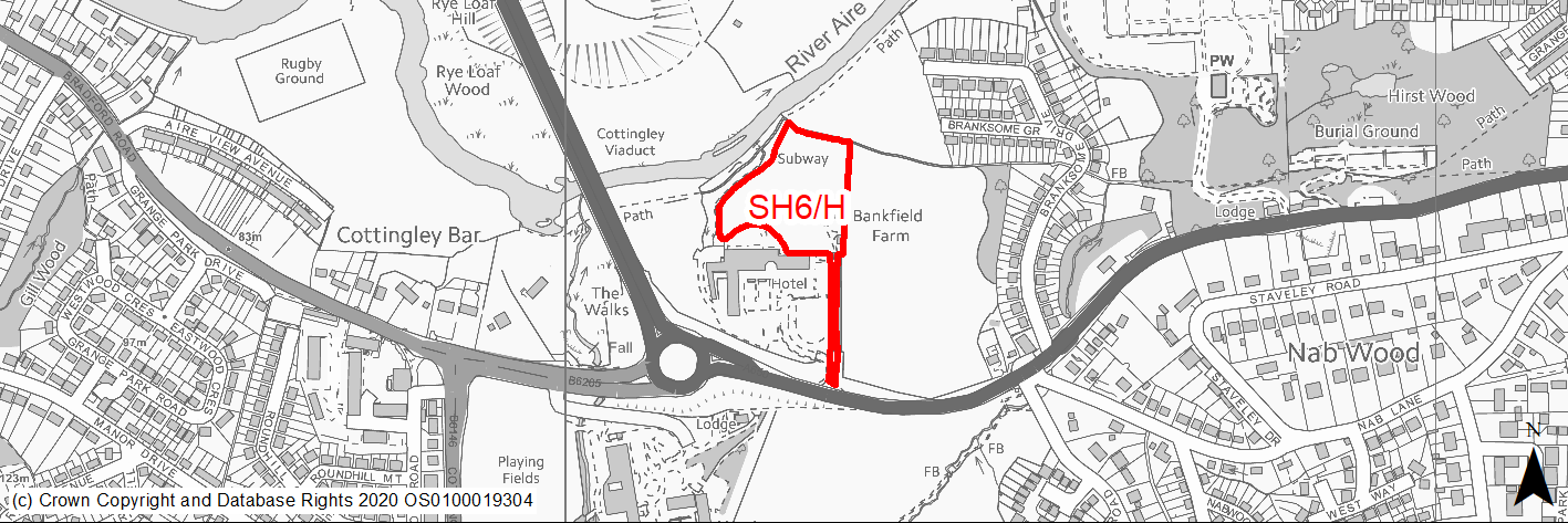
Site location
Regional City of Bradford- Shipley
Ward
Bingley Rural Ward
Site description
Open land to the North of the Mecure hotel. The site contains farm buidlings accessed from Bradford Road by a single width track. The site is bordered by woodland and the River Aire to the North and open fields to the North and East.
Proposed Allocation
Housing
SHLAA referencce
SH/028
Indicative no. dwellings
49
Site area (Gross) (ha)
1.57
Ownership
Private
Delivery timescales
Developable (6-11 years)
Type (PDL/Greenfield)
Greenfield
Green Belt
Yes
Flood Zone
Flood Zone 1. Small areas of zone 2 to north of site.
Potential site access
Access to the site is available via existing access on Bradford Road, which will need improvement.
Public Transport Accessibility
Site within 400m of a bus stop (Bingley Road) and beyond 800m of nearest rail station (Saltaire).
Sustainability Appraisal
A significant adverse effect has been predicted for the air quality SA Objective as a result of the site being partially situated within the CAZ. Development here could potentially make achieving air quality improvement targets within the CAZ more difficult.
Minor positive effects were predicted for most socio-economic themed SA Objectives due to the benefits of new residential development for the local economy as well as the location of the site in relation to transport links and health and education facilities, although residents may need to travel beyond the target distance to access services and amenities.
Minor adverse effects were predicted for a range of natural environment themed SA Objectives, primarily as a result of the impacts of new development on a 100% greenfield and Green Belt land which contains trees and adjoins an area of deciduous woodland priority habitat. At its closest point, the site is approximately 15m south of the River Aire which may be impacted upon by the construction and occupation of this site.
The site falls within the buffer zone for the Saltaire WHS, which may require consideration as part of any planning application.
Habitats Regulations Assessment
This site falls within 7km of the South Pennine Moors SPA/SAC. A HRA must be undertaken to ensure there are no significant effects on these protected sites. Developments within these zones must comply with Policy SP11; a SPD is being produced to provide further guidance.
Green Belt
See individual Green Belt site assessment in the accompanying report.
Constraints and Opportunities
• Site is within the WHS Buffer Zone.
• Detached Green Belt site can only come forward alongside SH/027.
• Impact on landscape character. The site is one of the last areas of open landscape buffer between Shipley and Cottingley.
• Impact on views from footpath receptors leading to and adjacent to the River Aire.
• Flood risk - part of the site to the north is within flood Zone 2.
• GI corridor, PROW, TPO woodland,and lcoal habitat network directly adjacent to north and west of the site.
Development considerations
• Full Ecological surveys and landscape assessment required to identify any impacts and mitigate accordingly.
• Buffers to existing woodland, hedgerows and waterways and buffer to the west of the site to extend the habitat network would be sought.
• Development to protect and incorporate existing trees/hedgerows within site and increase the tree cover.
• Compensatory Green Belt enhancement required.
• Retain and enhance GI links, habitat networks and PROW to north of the site.
• Avoid areas of higher flood risk through sequential approach to site layout.
Conclusion/Summary
This is a sustainably located green belt site, which would deliver an estimated 49 dwellings.
(23) SH7/H - Queens Road/Ferncliffe Road, Saltaire
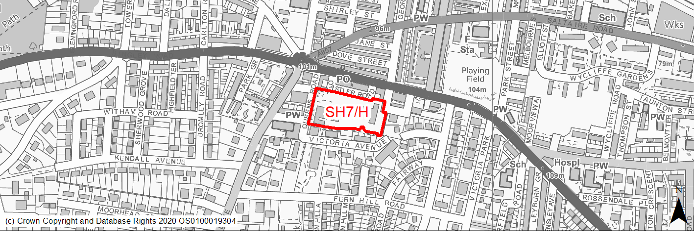
Site location
Regional City of Bradford- Shipley
Ward
Shipley Ward
Site description
The site consists of vacant unkept green area and is partly in use for car parking. Directly to the North of the site are retail uses and a pay and display Car Park. There are some mature trees and informal footpaths across the grassed areas of the site. The site is surrounded by residential uses.
Proposed Allocation
Housing
SHLAA referencce
SH/042
Indicative no. dwellings
30
Site area (Gross) (ha)
0.93
Ownership
Council/Private
Delivery timescales
Deliverable (0-5 years)
Type (PDL/Greenfield)
PDL
Green Belt
No
Flood Zone
Flood Zone 1
Potential site access
Access to the site is available from Queens Road and Victoria Avenue, which may require improvement.
Public Transport Accessibility
Site within 400m of a bus stop (Bingley Road) and 800m of nearest rail station (Saltaire).
Sustainability Appraisal
A significant adverse effect has been predicted for the air quality SA Objective as a result of the site being within the CAZ. No other significant adverse effects predicted. The site is 40m south of the Saltaire WHS and Conservation Area. Development at the site would be unlikely to be viewable from the WHS due to the presence of existing built form screening the site, but this would require careful consideration as part of any planning application. Given the site’s current condition, there is the potential for improvements to its visual amenity value, as well as improvements to the local townscape character.
Minor adverse effects have been predicted for most natural environment themed SA Objectives, primarily as a result of the effects associated with development on greenfield. The site is well located to provide residents here with good access to jobs, shops, buses, and cultural spaces, with particularly good access to schools and health facilities.
Habitats Regulations Assessment
This site falls within 7km of the South Pennine Moors SPA/SAC. A HRA must be undertaken to ensure there are no significant effects on these protected sites. Developments within these zones must comply with Policy SP11; a SPD is being produced to provide further guidance.
Green Belt
N/A – Site not within the Green Belt.
Constraints and Opportunities
• Site is in WHS Buffer Zone, close to WHS.
• Needs high quality design, scale, materials, boundary treatment, landscaping.
• Mainly brownfield site revegetated in part with potential wildlife value and protected species present.
• Potential for higher density/specialist housing.
Development considerations
• Ecological survey and heritage statement to identify any impacts and mitigate accordingly.
Conclusion/Summary
This is a sustainably located brownfield site within the settlement boundary, which would deliver an estimated 30 dwellings.
(3) SH8/H - The Old School Building, Wrose Brow Road
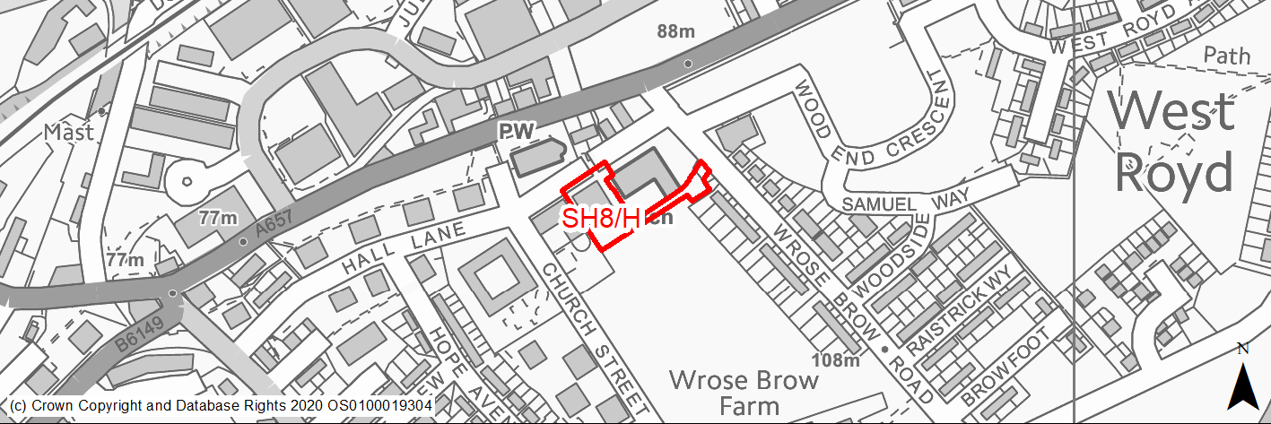
Site location
Regional City of Bradford- Shipley
Ward
Shipley Ward
Site description
Former school building.
Proposed Allocation
Housing
SHLAA referencce
SH/045
Indicative no. dwellings
10
Site area (Gross) (ha)
0.22
Ownership
Private
Delivery timescales
Developable (6-11 years)
Type (PDL/Greenfield)
PDL
Green Belt
No
Flood Zone
Flood Zone 1
Potential site access
Existing access off Wrose Brow Road.
Public Transport Accessibility
Public transport accessibility has been taken into account as part of the planning application process.
Sustainability Appraisal
The site could deliver a major positive effect for residents on the health SA Objective as a result of being within the target distances for all necessary health facilities.
Minor positive effects were predicted for nearly all other socio-economic themed SA Objectives due to the benefits of new residential development for the local economy as well as the location of the site in relation to transport links, local services and amenities, education facilities and employment areas.
As a PDL site containing a building, there are opportunities here for achieving biodiversity net gains and improving the local townscape character, depending on the how the development is designed and implemented.
The site falls within the buffer zone for the Saltaire WHS. Although the WHS is 1.4km north-east and potential for adverse effects as a result of development here is limited, this may still require consideration as part of any planning application.
Habitats Regulations Assessment
This site falls within 7km of the South Pennine Moors SPA/SAC a HRA must be undertaken to ensure there are no significant effects on these protected sites in terms of recreational pressures. Developments within these zones must comply with Policy SP11; an SPD is being produced to provide further guidance.
Green Belt
N/A – Site not within the Green Belt.
Constraints and Opportunities
• Relevant constraints and opportunities have been considered as part of the planning application process.
Development considerations
• Relevant development considerations have been taken into account as part of the planning application process.
Conclusion/Summary
This site has planning permission for 10 dwellings (16/04772/MAF approved 04.11.16).
(21) SH9/H - Shipley Tax Office
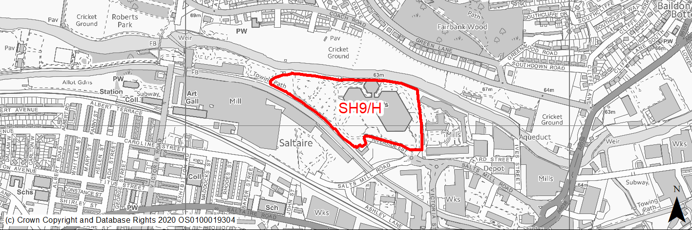
Site location
Regional City of Bradford- Shipley
Ward
Shipley Ward
Site description
Old tax office building by River Aire. Building on site being used. HMRC moving out of Shipley.
Proposed Allocation
Housing
SHLAA referencce
SH/052
Indicative no. dwellings
266
Site area (Gross) (ha)
4.73
Ownership
Private
Delivery timescales
Developable (6-11 years)
Type (PDL/Greenfield)
PDL
Green Belt
No
Flood Zone
Flood Zone 2 (80%), Flood Zone 3a (50%), small area Flood Zone 3b to the north.
Potential site access
The site can be accessed from the existing site entrance via Riverside Estate.
Public Transport Accessibility
Site within 400m of a bus stop (Bingley Road) and 800m of nearest rail station (Saltaire).
Sustainability Appraisal
The site could deliver major positive effects for residents on both the health and education SA Objectives as a result of being within the target distances for all necessary health facilities and centres for primary and secondary education.
A significant adverse effect has been predicted for the air quality SA Objective as a result of the site being entirely situated within the CAZ. Development here could potentially make achieving air quality improvement targets within the CAZ more difficult.
An additional major adverse effect arises for the climate change resilience SA Objective due to the site falling almost entirely within FZ2 and partially within FZ3a. Some limited areas are at medium to high risk of surface water flooding, and it is unclear if this land could be entirely avoided by careful layout due to the dispersion of the flood risk.
The site falls within the Saltaire WHS buffer zone with the western corner coinciding with the WHS. The southern perimeter of the site adjoins the Saltaire and Leeds Liverpool Canal Conservation Areas, and three Grade II Listed Buildings are adjacent. Given the highly sensitive nature of the WHS and the uncertainty around how the development would be implemented, a major adverse effect was also predicted for the cultural heritage SA Objective.
Minor positive effects were predicted for most socio-economic themed SA Objectives due to the benefits of new residential development for the local economy, as well as the location of the site in relation to transport links and local services.
As a PDL site, it is considered likely that new development would provide an opportunity to further enhance the biodiversity of the site, though it is unclear how it may affect the local townscape character as the site currently houses Shipley Tax Office, a prominent building in the local townscape.
The site is located between the Leeds and Liverpool Canal and the River Aire, meaning careful consideration around protecting water quality would be required.
Habitats Regulations Assessment
This site falls within 7km of the South Pennine Moors SPA/SAC. A HRA must be undertaken to ensure there are no significant effects on these protected sites. Developments within these zones must comply with Policy SP11; a SPD is being produced to provide further guidance.
Green Belt
N/A – Site not within the Green Belt.
Constraints and Opportunities
• Site is in WHS Buffer Zone, close to WHS and in settling of listed building (Victoria Mills) and Leeds Liverpool Canal Conservation Area. Needs high quality design, scale, materials, boundary treatment, landscaping.
• Flood risk - Flood Zone 2, 3 and areas of higher and medium SWFR within site.
• Green Infrastructure Corridor and local wildlife network (Leeds Liverpool canal) to north of site.
• Business development zone and loss of employment uses. Potential for mixed use site incorporating business and hotel uses.
Development considerations
• Existing Trees to be retained.
• Heritage Statament and mitigation important especially in relation to the riverside character.
• Potential for areas of higher density development.
• Site specific FRA and mitigation of surface water flood risk/drainage issues.
• Buffer to provide riverside habitat.
Conclusion/Summary
This is a sustainably located brownfield site, which would deliver an estimated 266 dwellings.
(13) SH10/H - Land to north and south of Dockfield Road
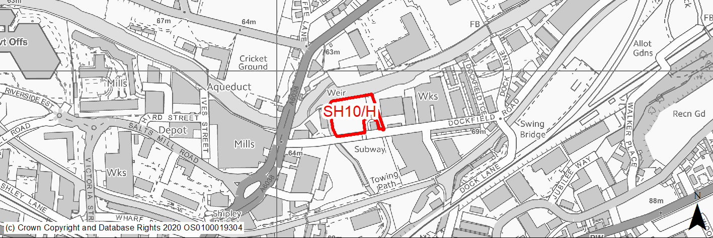
Site location
Regional City of Bradford- Shipley
Ward
Shipley Ward
Site description
The site comprises vacant land to the north and south of Dockfield Road in between the Leeds Liverpool Canal and River Aire. The sites have been previously developed for industrial use and are currently vacant. The Bradford Beck runs along the Western boundary. There are surrounding business uses.
Proposed Allocation
Mixed Use
SHLAA referencce
SH/058
Indicative no. dwellings
50
Site area (Gross) (ha)
1.26
Ownership
Private
Delivery timescales
Developable (6-11 years)
Type (PDL/Greenfield)
PDL
Green Belt
No
Flood Zone
North of Dockfield Road Flood Zone 3a and functional floodplain along River Aire (majority). South of Dockfield Road Flood Zone 2 (parts) and Flood Zone 3 (limited) to west of site along Bradford Beck.
Potential site access
There is a level difference between Dockfield Road and the site and a level access would need to be provided around 1 in 40 for the first 10m into the site. The TA should also assess highway structures on and in the vicinity of the site with a view to making these safe.
Public Transport Accessibility
Site within 400m of a bus stop and 800m of nearest rail station (Shipley).
Sustainability Appraisal
Site has been subject to a recent Sustainability Appraisal (SA) as part of the Area Action Plan process, for additional appraisal commentary please see the site reference within the Sustainability Appraisal accompanying the Local Plan.
Habitats Regulations Assessment
This site falls within 7km of the South Pennine Moors SPA/SAC. A HRA must be undertaken to ensure there are no significant effects on these protected sites. Developments within these zones must comply with Policy SP11; a SPD is being produced to provide further guidance.
Green Belt
N/A – Site not within the Green Belt.
Constraints and Opportunities
• Mixed use opportunity - the comprehensive redevelopment of the site will be supported. The land to the south of Dockfield Road is suitable for mixed use development.
• The land to the north should be considered for water compatible uses including green infrastructure, open space and flood risk management as part of any comprehensive redevelopment of the site.
• Business use with supporting residential site suitable for higher density residential use.
• Site is in WHS Buffer Zone.
• High floodrisk - Flood Zone 2 and 3.
• Improvements to pedestrian and cycle links within and through the site to existing networks, including along the Bradford Beck and the canal towpath, would help to connect the development to the surrounding area and encourage walking and cycling.
• Intersects the Northern Gas Networks High Pressure Pipeline (Policy SCRC/HSC1).
Development considerations
Development will be expected to:
• Include high density residential as part of mixed use development.
• Safeguard and enhance the setting of the Leeds and Liverpool Conservation Area and SEGI, including providing a high quality frontage to the canal.
• Provide improvements to green infrastructure and ecological assets including; enhancement of adjacent water ways and habitat networks and incorporate on site amenity space and wildlife areas alongside the and Bradford Beck and River Aire.
• Contribute to appropriate and proportionate improvements to the canal towpath. Flood Risk Dockfield Road North is identified as being at significant risk from the River Aire with the majority of the site located in the functional flood plain (flood zone 3b). Development will not be considered appropriate in zone 3b (with the exception of essential infrastructure (subject to passing the Exception Test) and water compatible uses). As part of any comprehensive redevelopment of the site, development proposals will be expected to consider flood risk mitigation or resilience measures, which could include a further assessment of the Dockfield Road North for open space/flood control infrastructure. More vulnerable uses including residential uses should be directed to Dockfield Road South and areas of lower flood risk.
• Any detailed site specific flood risk assessment, should consider a review and update of the 2005 Upper Aire model, to assess whether the outputs may lower the risk to the site based on more up to-date hydrological conditions and model components, in line with the recommendations of the SFRA Level 2. A site specific FRA will need to demonstrate any proposed development will be safe for its lifetime and consider mitigation or resilience measures which could include further assessment of DF4 for open space/flood control infrastructure, including details of type of development, design, layout depth of flooding and velocities (including the new climate change allowances). Depending on the type of development and risk of flooding, a flood warning and evacuation plan may also be required.
Development will be expected to:
• Be supported by a site specific flood risk assessment.
• Result in no net loss of the functional floodplain (zone 3b) and not increase flood risk elsewhere.
• Safeguard land in the functional floodplain for green infrastructure, open space and flood risk management.
• Development proposals should be accompanied by a Transport Assessment detailing access and service arrangements and connectivity to the wider highway network. Pedestrian facilities at junctions between the site and the town centre should be assessed and improvements made where required.
Conclusion/Summary
The site was previously allocated for mixed use in the SCRC AAP (DF4). This is a sustainably located brownfield site, which would deliver an estimated 50 dwellings.
(5) SH11/H - Land around Crag Road Flats
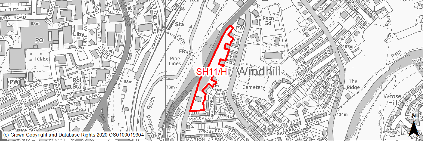
Site location
Regional City of Bradford- Shipley
Ward
Windhill and Wrose Ward
Site description
Well maintained grassy bank with mature trees.
Proposed Allocation
Housing
SHLAA referencce
SH/059
Indicative no. dwellings
30
Site area (Gross) (ha)
0.92
Ownership
Private
Delivery timescales
Developable (6-11 years)
Type (PDL/Greenfield)
Greenfield
Green Belt
No
Flood Zone
Flood Zone 1
Potential site access
Access would be preferred from Crag Road to the south of its junction with Briggate to avoid conflicts with the approved main access for the adjacent site.
Public Transport Accessibility
Site within 400m of a bus stop (Leeds Road) and 800m of nearest rail station (Shipley).
Sustainability Appraisal
Site has been subject to a recent Sustainability Appraisal (SA) as part of the Area Action Plan process, for additional appraisal commentary please see the site reference within the Sustainability Appraisal accompanying the Local Plan.
Habitats Regulations Assessment
This site falls within 7km of the South Pennine Moors SPA/SAC. A HRA must be undertaken to ensure there are no significant effects on these protected sites. Developments within these zones must comply with Policy SP11; a SPD is being produced to provide further guidance.
Green Belt
N/A – Site not within the Green Belt.
Constraints and Opportunities
• Current amenity open space, mature trees on site.
• The site offers the potential for low density residential infilling.
Development considerations
• Traffic Regulation Orders (TROs) may be required on Crag Road along the site frontage to prevent on-street parking.
• Existing mature trees should be retained.
Conclusion/Summary
The site was previously allocated for residential use in the SCRC AAP (SE2). This is a sustainably located greenfield site, which would deliver an estimated 30 dwellings.
(11) SH12/H - Crag Road
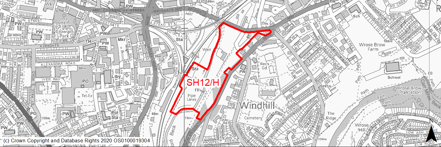
Site location
Regional City of Bradford- Shipley
Ward
Windhill and Wrose Ward
Site description
The site comprises a large area of underused land to the east of Shipley station alongside Crag Road. The site is in a highly accessible location close to Shipley station. The Bradford Beck and line of the former Bradford Canal run through the site, which forms the northern end of a strategic green corridor running from Bradford city centre to Shipley.
Proposed Allocation
Housing
SHLAA referencce
SH/060
Indicative no. dwellings
78
Site area (Gross) (ha)
5.02
Ownership
Private
Delivery timescales
Developable (6-11 years)
Type (PDL/Greenfield)
Greenfield
Green Belt
No
Flood Zone
Flood Zone 1, Flood Zone 2 and Flood Zone 3a
Potential site access
The site can be accessed from Birggate. This will require a new access to be created and bridge over the Beck to provide vehicle access the western part of the site.
Public Transport Accessibility
Site within 400m of a bus stop (Leeds Road) and 800m of nearest rail station (Shipley).
Sustainability Appraisal
Site has been subject to a recent Sustainability Appraisal (SA) as part of the Area Action Plan process, for additional appraisal commentary please see the site reference within the Sustainability Appraisal accompanying the Local Plan.
Habitats Regulations Assessment
This site falls within 7km of the South Pennine Moors SPA/SAC. A HRA must be undertaken to ensure there are no significant effects on these protected sites. Developments within these zones must comply with Policy SP11; a SPD is being produced to provide further guidance.
Green Belt
N/A – Site not within the Green Belt.
Constraints and Opportunities
• This is an edge of centre site in a highly accessible location, close to the railway station and in an area where the local highway network is already at or near capacity.
• Improvements to pedestrian and cycle links within and through the site to existing networks would help to connect the development to the surrounding area and encourage walking and cycling.
• The site intersects the Northern Gas Networks High Pressure Pipeline and the National Grid Electricity Transmission.
• Flood Risk - areas of Flood zone 2 and 3 within site along Bradford Beck.
• The Bradford Beck and line of the former Bradford Canal run through the site.
• Site is within the WHS Buffer zone and on a key prominant gateway to the WHS.
• The site includes Grassland habitat network and is part of Key Green Infrastrucutre Corridor and Linear Park running form Bradford city centre to Shipley along Bradford Beck.
• Part of the site is a TPO Woodland.
Development considerations
Due to the site’s size and location development will be expected to provide:
• A strong sense of place. The design process should be informed by the preparation of a Masterplan/ urban design framework which shows how the different elements of the scheme – the streets, paths, bridges, green infrastructure, public spaces, homes and commercial uses – will all combine to create a high quality development which optimises the potential of the site’s location and its features. Proposals should be referred to independent design review at an early stage.
• Enhanced built form and public realm with a strong frontage to Leeds Road to create an enhanced gateway to Shipley and the World Heritage Site of Saltaire.
Development will be expected to:
• Be supported by a site specific flood risk assessment with mitigation of surface water floodrisk/drainage issues.
• Result in no net loss of the functional floodplain (flood zone 3b) and not increase flood risk elsewhere.
• Safeguard areas of the functional floodplain for green infrastructure and water compatible uses.
• Any development proposals should be accompanied by a Transport Assessment detailing access and service arrangements and connectivity to the wider highway network and Shipley Town Centre.
• Development proposals will need to consider the potential presence of unstable land and any planning applications are expected to be accompanied by a Mining Risk Assessment protect an alignment for the proposed Shipley Eastern Relief Road.
• Protect the line of the Bradford Canal to accommodate future aspirations to reinstate the Bradford Canal.
• Support the role of Shipley station as a transport hub through the potential provision of car parking for the station.
• Incorporate and facilitate high quality Canal Road Greenway cycle links through the site to Dock Lane and Shipley station.
• Minimise traffic impacts and provide proportionate highway improvements including Leeds Road/Crag Road junction, pedestrian and cycle crossing facilities on Cragg Road and Leeds Road.
• Fund Traffic Regulation Orders (TROs) on adjacent roads to control on-street parking and to protect access visibility splays. The site is suitable for a residential led mixed use development with supporting business and retail uses linked to Shipley station and the town centre.
The development will be expected to provide:
• A mix of house types and sizes, including family sized housing and higher density flats/apartments.
• Supporting business and commercial uses centred around the station.
• Supporting retail of an appropriate scale, subject to Core Strategy Policy EC5.
• New high quality pedestrian and cycle routes to connect the new development to Shipley station and the town centre. Opportunities should be considered to re-open pedestrian links under the train line to Shipley Station and the town centre.
• Significant improvements to green infrastructure as part of the Linear Park including; protection and enhancement of green corridors and habitat networks alongside the Bradford Beck, the creation of new open space and wildlife areas and improvements to the quality and setting of Bradford Beck. Proposals require a full Ecological survey and heritage statement to identify any impacts and mitigate accordingly. Existing mature and protected trees to be retained.
Conclusion/Summary
The site was previously allocated for residential use in the SCRC AAP (SE1). This is a sustainably located greenfield site, which would deliver an estimated 78 dwellings.
(7) SH13/H - Regent House
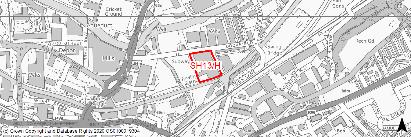
Site location
Regional City of Bradford- Shipley
Ward
Shipley Ward
Site description
The site contains a range of mill buildings, connecting single story buildings and Regent House along Dockfield Road.
Proposed Allocation
Housing
SHLAA referencce
SH/061
Indicative no. dwellings
93
Site area (Gross) (ha)
0.69
Ownership
Private
Delivery timescales
Developable (6-11 years)
Type (PDL/Greenfield)
PDL
Green Belt
No
Flood Zone
Flood Zone 1 with small area Flood Zone 2 to north west of site
Potential site access
The site can be accessed from existing site access off Dockfield Road.
Public Transport Accessibility
Site within 400m of a bus stop and 800m of nearest rail station (Shipley).
Sustainability Appraisal
Site has been subject to a recent Sustainability Appraisal (SA) as part of the Area Action Plan process, for additional appraisal commentary please see the site reference within the Sustainability Appraisal accompanying the Local Plan.
Habitats Regulations Assessment
This site falls within 7km of the South Pennine Moors SPA/SAC. A HRA must be undertaken to ensure there are no significant effects on these protected sites. Developments within these zones must comply with Policy SP11; a SPD is being produced to provide further guidance.
Green Belt
N/A – Site not within the Green Belt.
Constraints and Opportunities
• The redevelopment of the site, including the conversion of historic mill buildings, will contribute to the regeneration of the Dockfield Road area and enhance the setting of the Leeds and Liverpool Canal.
Development considerations
• The site is suitable for residential redevelopment, including conversion of historic mill buildings.
Development will be expected to:
• Safeguard and enhance the setting of the Leeds and Liverpool Conservation Area and SEGI and key heritage assets including, grade 2 listed Junction Bridge and the unlisted mill buildings and provide a high quality frontage to the canal.
• Provide appropriate and proportionate improvements to the canal towpath and the Junction Road footpath. TROs may be required on Dockfield Road to control on-street parking and to protect visibility splays. This is an edge of centre site in a highly accessible location, close to the railway station and in an area where the local highway network is already at or near capacity. Therefore the development would be required to minimise traffic generation and incorporate a Travel Plan taking into account the adjacent core public transport, cycling and walking networks.
• Development proposals should be accompanied by a Transport Statement detailing access and service arrangements and connectivity to the wider highway network.
• Improvements to pedestrian and cycle links within and through the site to existing networks, including to the canal towpath, would help to connect the development to the surrounding area and encourage walking and cycling.
Conclusion/Summary
The site was previously allocated for residential use in the SCRC AAP (DF5). This is a sustainably located brownfield site, which would deliver an estimated 93 dwellings.
(8) SH14/H - Market Hall
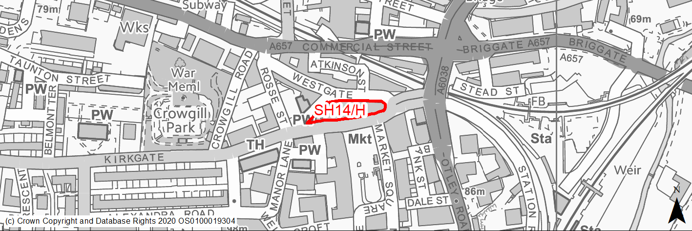
Site location
Regional City of Bradford- Shipley
Ward
Shipley Ward
Site description
The site is occupied by the indoor market hall building and the town’s distinctive clock tower. The building is currently in use but is need of investment.
Proposed Allocation
Housing
SHLAA referencce
SH/062
Indicative no. dwellings
20
Site area (Gross) (ha)
0.18
Ownership
Private
Delivery timescales
Developable (6-11 years)
Type (PDL/Greenfield)
PDL
Green Belt
No
Flood Zone
Flood Zone 1
Potential site access
Any vehicular access should be as existing from New Kirkgate, direct access from Kirkgate would be unacceptable.
Public Transport Accessibility
Site within 400m of a bus stop and 800m of nearest rail station (Shipley).
Sustainability Appraisal
Site has been subject to a recent Sustainability Appraisal (SA) as part of the Area Action Plan process, for additional appraisal commentary please see the site reference within the Sustainability Appraisal accompanying the Local Plan.
Habitats Regulations Assessment
This site falls within 7km of the South Pennine Moors SPA/SAC. A HRA must be undertaken to ensure there are no significant effects on these protected sites. Developments within these zones must comply with Policy SP11; a SPD is being produced to provide further guidance.
Green Belt
N/A – Site not within the Green Belt.
Constraints and Opportunities
• Mixed use opportunity.
• The site is within the town centre site in a highly accessible location, close to the railway station.
• Key Gateway site within the World Heritage Site Buffer Zone with local landmark clocktower.
Development considerations
• The redevelopment/refurbishment of the Indoor Market Hall for retail-led mixed use development, including main town centre and residential uses, will be supported.
Development proposals for the site should:
• Make provision for a building which is a landmark in the town centre. This could include the retention of the existing building, or elements of it, as part of the scheme.
• Ensure any new building is an appropriate scale in terms of contributing to a sense of enclosure to the Market Square and responds sensitively to its setting in the World Heritage Site buffer zone.
• Provide an improved gateway to the town centre for those arriving from Saltaire or the Leeds and Liverpool Canal.
• Utilise opportunities above ground floor level to create a mix of business, commercial and residential uses and maintain active ground floor uses appropriate to the Primary Shopping Area, fronting Market Square and Westgate.
• Contribute to appropriate and proportionate public realm enhancements along Westgate and Kirkgate and seek to enhance pedestrian links between Market Square and Westgate.
Transport and Movement:
• The site is located in the town centre and therefore the development would be required to minimise traffic generation and incorporate a Travel Plan taking into account the adjacent core public transport, cycling and walking networks.
• Development proposals should be accompanied by a Transport Statement detailing access and service arrangements and connectivity to the wider highway network. The existing on-site parking serves an important function in this locality and replacement short stay public parking should be incorporated into the development. Due to the site’s location development would be expected to justify any level of long duration parking provision residential units/business uses on upper floors with active commercial and supporting leisure uses on the ground/lower floors.
Conclusion/Summary
The site was previously allocated for mixed use in the SCRC AAP (STC1). This is a sustainably located brownfield site, which would deliver an estimated 20 dwellings.
(11) SH15/H - Buildings along Briggate
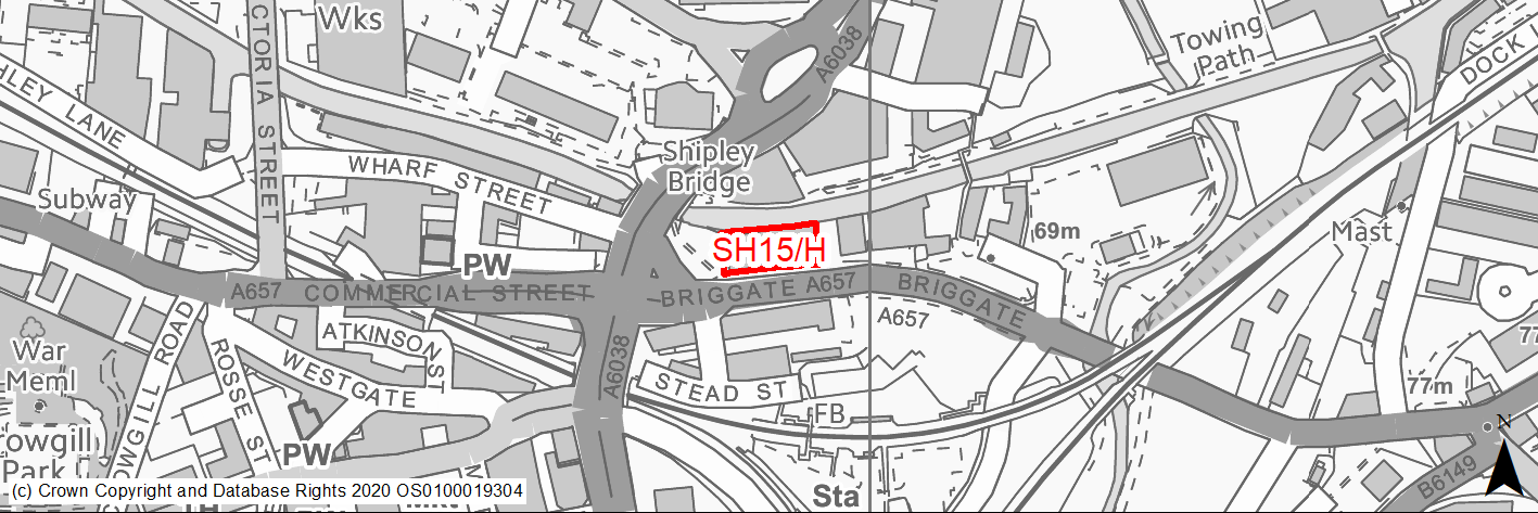
Site location
Regional City of Bradford- Shipley
Ward
Shipley Ward
Site description
The site is located on a key gateway to Shipley and Saltaire, and includes vacant land of former cinema and adjacent building fronting Briggate.
Proposed Allocation
Housing
SHLAA referencce
SH/063
Indicative no. dwellings
20
Site area (Gross) (ha)
0.13
Ownership
Private
Delivery timescales
Developable (6-11 years)
Type (PDL/Greenfield)
PDL
Green Belt
No
Flood Zone
Flood Zone 1
Potential site access
The site can be accessed from existing site access off Briggate, which will need improvement.
Public Transport Accessibility
Site within 400m of a bus stop and 800m of nearest rail station (Shipley).
Sustainability Appraisal
Site has been subject to a recent Sustainability Appraisal (SA) as part of the Area Action Plan process, for additional appraisal commentary please see the site reference within the Sustainability Appraisal accompanying the Local Plan.
Habitats Regulations Assessment
This site falls within 7km of the South Pennine Moors SPA/SAC. A HRA must be undertaken to ensure there are no significant effects on these protected sites. Developments within these zones must comply with Policy SP11; a SPD is being produced to provide further guidance.
Green Belt
N/A – Site not within the Green Belt.
Constraints and Opportunities
• The redevelopment of the site for residential led mixed use development will be supported. The site will be suitable for a mix of uses including leisure, retail and other main town centre uses, with residential uses on upper floors.
• Prominent gateway site within the WHS buffer zone.
• Air Quality Issues (Briggate).
• Improvements to pedestrian and cycle links through the site and along Briggate to existing networks would help to connect the development to the surrounding area and encourage walking and cycling.
• Site is adjacent the Leeds and Liverpool canal conservation area, local wildlife network and Green Infrastructure Corridor.
Development considerations
Development should:
• Take opportunities to provide an improved gateway to Shipley and Saltaire and enhance the setting of the Leeds and Liverpool Canal Conservation Area. Development will be expected to provide high quality architectural design to safeguard and enhance the setting of the World Heritage Site.
• Provide active ground floor uses where possible, fronting Briggate.
• Deliver high density residential development.
• The site is located in the town centre, in a highly accessible location, close to the railway station and in an area where the local highway network is already at or near capacity. Therefore the development would be required to minimise traffic generation and incorporate a Travel Plan taking into account the adjacent core public transport, cycling and walking networks. A car-free development may be appropriate here, given its sustainable location.
Conclusion/Summary
The site was previously allocated for mixed use in the SCRC AAP (STC6). This is a sustainably located brownfield site, which would deliver an estimated 20 dwellings.
(11) SH16/H - Market Square
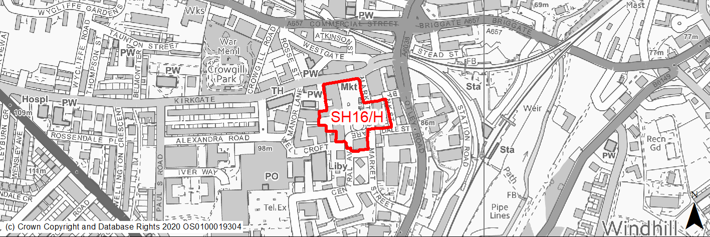
Site location
Regional City of Bradford- Shipley
Ward
Shipley Ward
Site description
Mixed use town centre buildings, market square and public car park.
Proposed Allocation
Housing
SHLAA referencce
SH/064
Indicative no. dwellings
25
Site area (Gross) (ha)
1.15
Ownership
Private/Council
Delivery timescales
Developable (6-11 years)
Type (PDL/Greenfield)
PDL
Green Belt
No
Flood Zone
Flood Zone 1
Potential site access
Access to the site is available from the surrounding road network.
Public Transport Accessibility
Site within 400m of a bus stop and 800m of nearest rail station (Shipley).
Sustainability Appraisal
Site has been subject to a recent Sustainability Appraisal (SA) as part of the Area Action Plan process, for additional appraisal commentary please see the site reference within the Sustainability Appraisal accompanying the Local Plan.
Habitats Regulations Assessment
This site falls within 7km of the South Pennine Moors SPA/SAC. A HRA must be undertaken to ensure there are no significant effects on these protected sites. Developments within these zones must comply with Policy SP11; a SPD is being produced to provide further guidance.
Green Belt
N/A – Site not within the Green Belt.
Constraints and Opportunities
• Key regeneration site within the town centre and World Heritage Site Buffer Zone.
• The land and buildings around Market Square provide an excellent opportunity for strengthening the town centre through high quality retail led redevelopment and public realm enhancements.
Development considerations
• The redevelopment/refurbishment of buildings around market square for retail and new retail-led mixed use development, including main town centre and residential uses, will be supported. Development proposals should: Support the vitality and viability of Shipley town centre and retain the primary retail function of the Primary Shopping Area, in accordance with Policy SCRC/SE5.
• Maintain active ground floor uses and enhance frontages facing Market Square and utilise opportunities above ground floor level to create a mix of business, commercial and residential uses.
• Contribute to appropriate and proportionate public realm enhancements to Market Square.
• Safeguard the character and setting of Grade II listed Manor Lane Wesleyan Reformed Church.
• The site is located in the town centre and therefore the development would be required to minimise traffic generation and incorporate a Travel Plan taking into account the adjacent core public transport, cycling and walking networks.
• Development proposals should be accompanied by Transport Statement detailing access and service arrangements and connectivity to the wider highway network.
Market Square improvements:
• The Council will work with partners and the local community to support and encourage projects to improve the public realm around Market Square.
Development will be expected to:
• Strengthen the Primary Shopping Area and Market Square as a focus for the town centre. Improve vehicular access and the quality of parking areas in the town centre.
• Retain and enhance Shipley market, in accordance with Policy SCRC/SE6 Market Provision.
• Be of high quality design to reconnect the town centre with its quality-built heritage and enhance the setting of Saltaire. Include new and enhanced green infrastructure assets within the town centre.
• Improvements to pedestrian and cycle links within and through the site to existing networks would help to connect the development to the surrounding area and encourage walking and cycling.
Conclusion/Summary
The site was previously allocated for mixed use in the SCRC AAP (STC2). This is a sustainably located brownfield site, which would deliver an estimated 25 dwellings.
(6) SH17/H - Shipley Gateway Site
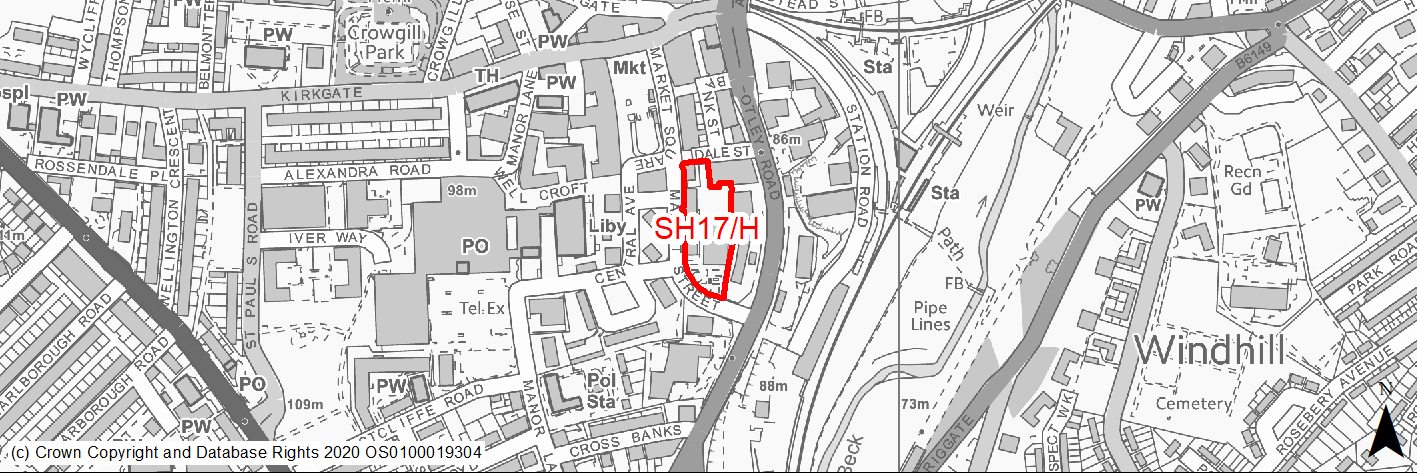
Site location
Regional City of Bradford- Shipley
Ward
Shipley Ward
Site description
The site offers a gateway position to Shipley from the southern approaches. The site includes town centre buildings which are underused and in need of investment. The site consists of a mix of uses, including retail and leisure and car parking.
Proposed Allocation
Housing
SHLAA referencce
SH/065
Indicative no. dwellings
50
Site area (Gross) (ha)
0.49
Ownership
Private/Council
Delivery timescales
Developable (6-11 years)
Type (PDL/Greenfield)
PDL
Green Belt
No
Flood Zone
Flood Zone 1
Potential site access
Access to the site is available from the existing access on Dale Street and Market Street.
Public Transport Accessibility
Site within 400m of a bus stop and 800m of nearest rail station (Shipley).
Sustainability Appraisal
Site has been subject to a recent Sustainability Appraisal (SA) as part of the Area Action Plan process, for additional appraisal commentary please see the site reference within the Sustainability Appraisal accompanying the Local Plan.
Habitats Regulations Assessment
This site falls within 7km of the South Pennine Moors SPA/SAC. A HRA must be undertaken to ensure there are no significant effects on these protected sites. Developments within these zones must comply with Policy SP11; a SPD is being produced to provide further guidance.
Green Belt
N/A – Site not within the Green Belt.
Constraints and Opportunities
• Key gateway regeneration site within the town centre and World Heritage Site Buffer Zone.
• The inclusion of adjacent land/buildings along Otley Road and Dale Street to deliver a comprehensive redevelopment will be supported, subject to landowner agreement.
Development considerations
• The comprehensive redevelopment of land or buildings for retail/leisure/residential led mixed use development, including main town centre uses, to create an enhanced gateway to the town centre will be supported. Hotel and business uses will also be encouraged as part of the mix respond to its gateway position and create a strong relationship with the rest of the town centre, in particular Market Square.
• Provide active ground floor uses where possible to all public frontages, as appropriate within the town centre and utilise opportunities above ground floor level to create a mix of business, commercial and residential uses.
• Respond positively to buildings in use along Otley Road/Dale Street, and work with adjoining land owners to deliver a comprehensive scheme.
Transport and Movement:
• The site is located in the town centre and therefore the development would be required to minimise traffic generation and incorporate a Travel Plan taking into account the adjacent core public transport, cycling and walking networks.
• Development proposals should be accompanied by Transport Statement detailing access and service arrangements and connectivity to the wider highway network.
• Improvements to pedestrian and cycle links within and through the site to existing networks, including along Market Street between Market Square and Otley Road, would help connect the development to the station and Market Square and encourage walking and cycling.
Conclusion/Summary
The site was previously allocated for mixed use in the SCRC AAP (STC4). This is a sustainably located brownfield site, which would deliver an estimated 50 dwellings.
(5) SH19/H - Land between Leeds Road and Dock Lane
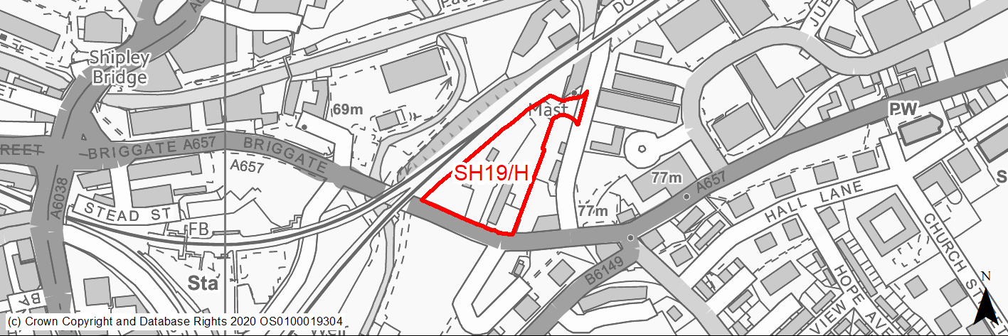
Site location
Regional City of Bradford- Shipley
Ward
Shipley Ward
Site description
The site is located on a key gateway route into Shipley and Saltaire fronting onto Leeds Road and is current in use for industrial/waste management.
Proposed Allocation
Housing
SHLAA referencce
SH/067
Indicative no. dwellings
60
Site area (Gross) (ha)
0.71
Ownership
Private
Delivery timescales
Developable (6-15 years)
Type (PDL/Greenfield)
PDL
Green Belt
No
Flood Zone
Flood Zone 1
Potential site access
There should be no new site access from Leeds Road. The existing site access from Dock Lane would be suitable.
Public Transport Accessibility
Site within 400m of a bus stop and 800m of nearest rail station (Shipley).
Sustainability Appraisal
Site has been subject to a recent Sustainability Appraisal (SA) as part of the Area Action Plan process, for additional appraisal commentary please see the site reference within the Sustainability Appraisal accompanying the Local Plan.
Habitats Regulations Assessment
This site falls within 7km of the South Pennine Moors SPA/SAC. A HRA must be undertaken to ensure there are no significant effects on these protected sites. Developments within these zones must comply with Policy SP11; a SPD is being produced to provide further guidance.
Green Belt
N/A – Site not within the Green Belt.
Constraints and Opportunities
• Site within the WHS buffer zone and directly adjacent the Leeds Liverpool canal Conservation Area.
• The regeneration of the site presents the opportunity to provide a more attractive frontage onto Leeds Road and Shipley East and enhance the setting of the Leeds and Liverpool Canal and Saltaire World Heritage Site.
• The site’s location opposite Shipley East and in close proximity to the station, gives it potential for redevelopment as part of the regeneration of the area.
• Improvements to pedestrian and cycle links within and through the site to existing networks would help to connect the development to the surrounding area and encourage walking and cycling. This should include exploring the potential of creating a link between the railway station and the canal through the site via Junction Bridge.
Development considerations
• The site is suitable for suitable for business, commercial and residential uses.
• Redevelopment proposals should consider the comprehensive redevelopment of the site, including the relocation of the scrap yard subject to landowner agreement.
• This is an edge of centre site in a highly accessible location, close to the railway station and in an area where the local highway network is already at or near capacity. Therefore the development would be required to minimise traffic generation and incorporate a Travel Plan taking into account the adjacent core public transport, cycling and walking networks.
• Development proposals should be accompanied by a Transport Assessment detailing access and service arrangements and connectivity to the wider highway network.
• Provision of direct pedestrian links to Leeds Road should be considered to compensate for substandard pedestrian facilities on Dock Lane.
• Development of the site will be expected to: Provide high density residential development, including flats/apartments.
• Provide a strong frontage to Leeds Road to create an enhanced gateway to Shipley and the World Heritage Site of Saltaire.
• Safeguard and enhance the setting of Leeds and Liverpool Canal Conservation Area and key unlisted buildings, including the former Shipley and Windhill Railway Station and Pumping Station, which should be retained and integrated into any proposed redevelopment of the site.
• Accommodate future ambitions to reinstate the Bradford Canal.
• Provide a positive visual backdrop when seen from the adjacent railway line.
Conclusion/Summary
The site was previously allocated for mixed use in the SCRC AAP (DF3). This is a sustainably located brownfield site, which would deliver an estimated 60 dwellings.
(4) SH20/H - Station Road
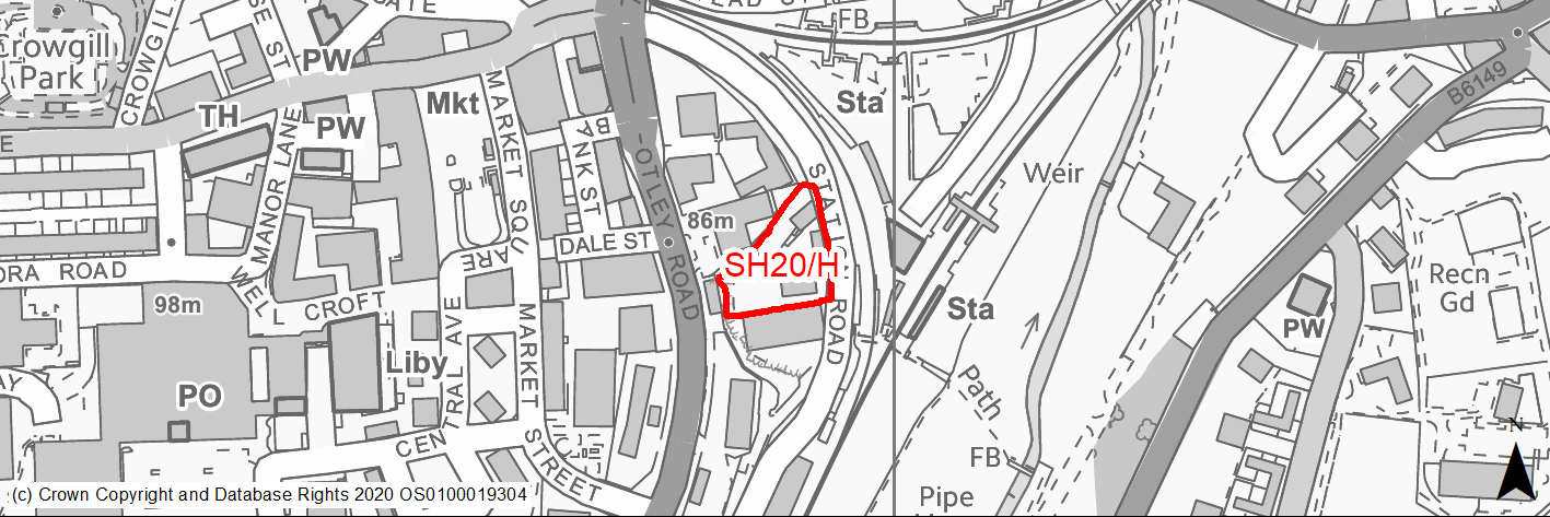
Site location
Regional City of Bradford- Shipley
Ward
Shipley Ward
Site description
The site is currently in industrial use and is located in within an old quarry with high steeply sloping sides to the north and west.
Proposed Allocation
Housing
SHLAA referencce
SH/068
Indicative no. dwellings
50
Site area (Gross) (ha)
0.3
Ownership
Private
Delivery timescales
Developable (6-11 years)
Type (PDL/Greenfield)
PDL
Green Belt
No
Flood Zone
Flood Zone 1
Potential site access
Vehicular access is available from Station Road which is currently an unadopted road which would need to be brought up to adoptable standards for the Highway Authority to support any development proposals.
Public Transport Accessibility
Site within 400m of a bus stop and 800m of nearest rail station (Shipley).
Sustainability Appraisal
Site has been subject to a recent Sustainability Appraisal (SA) as part of the Area Action Plan process, for additional appraisal commentary please see the site reference within the Sustainability Appraisal accompanying the Local Plan.
Habitats Regulations Assessment
This site falls within 7km of the South Pennine Moors SPA/SAC. A HRA must be undertaken to ensure there are no significant effects on these protected sites. Developments within these zones must comply with Policy SP11; a SPD is being produced to provide further guidance.
Green Belt
N/A – Site not within the Green Belt.
Constraints and Opportunities
• The site is in a highly accessible location close to Shipley train station and is suitable for high density residential redevelopment.
Development considerations
Development of the site will be expected to:
• Provide high density residential development, including flats/apartments.
• Provide a strong frontage to Leeds Road to create an enhanced gateway to Shipley and the World Heritage Site of Saltaire.
• Safeguard and enhance the setting of Leeds and Liverpool Canal Conservation Area and key unlisted buildings, including the former Shipley and Windhill Railway Station and Pumping Station, which should be retained and integrated into any proposed redevelopment of the site.
• Accommodate future ambitions to reinstate the Bradford Canal in accordance with Policy SCRC/ST8.
• Provide a positive visual backdrop when seen from the adjacent railway line. The site is located in the town centre and therefore the development would be required to minimise traffic generation and incorporate a Travel Plan taking into account the adjacent core public transport, cycling and walking networks.
• Development proposals should be accompanied by a Transport Statement detailing access and service arrangements and connectivity to the wider highway
• network The site may be suitable for car free development given its highly accessible town centre location.
• The site will need evaluation with regard to the potential presence of archaeological features associated with the Bradford Canal which operated between the 18th and early 20th centuries. This is an edge of centre site in a highly accessible location, close to the railway station and in an area where the local highway network is already at or near capacity. Therefore the development would be required to minimise traffic generation and incorporate a Travel Plan taking into account the adjacent core public transport, cycling and walking networks.
• Development proposals should be accompanied by a Transport Assessment detailing access and service arrangements and connectivity to the wider highway network.
Conclusion/Summary
The site was previously allocated for residential use in the SCRC AAP (STC3). This is a sustainably located brownfield site, which would deliver an estimated 50 dwellings.
(3) SH21/H - Wrose Brow Road, Windhill
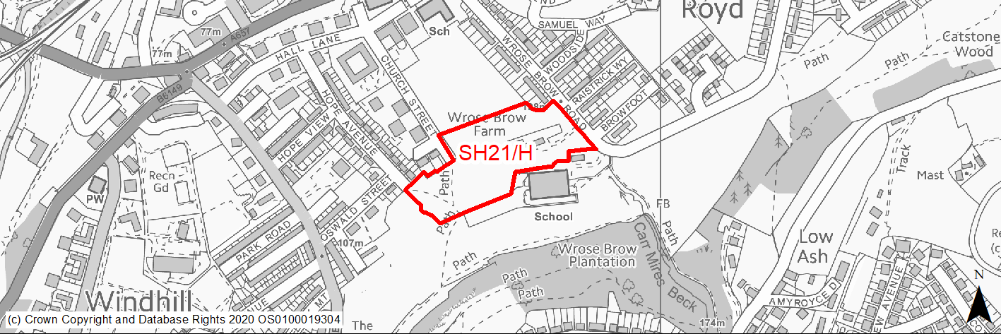
Site location
Regional City of Bradford- Shipley
Ward
Windhill and Wrose Ward
Site description
Unmaintained grassland bordering playing field and wider greenspace. Several derelict garages and outbuildings.
Proposed Allocation
Housing
SHLAA referencce
SH/057
Indicative no. dwellings
50
Site area (Gross) (ha)
1.99
Ownership
Council/Private
Delivery timescales
Developable (6-11 years)
Type (PDL/Greenfield)
Mixed
Green Belt
No
Flood Zone
Flood Zone 1
Potential site access
Vehicular access is available from Wrose Brow Road and Hope Avenue which will need improvement.
Public Transport Accessibility
Site within 400m of a bus stop (Leeds Road) and beyond 800m of nearest rail station (Shipley).
Sustainability Appraisal
The site could deliver a major positive effect for residents on the health SA Objective as a result of being within the target distances for all necessary health facilities.
Minor positive effects were predicted for nearly all other socio-economic themed SA Objectives due to the benefits of new residential development for the local economy as well as the location of the site in relation to transport links, local services and amenities, education facilities and employment areas.
No major adverse effects have been predicted for the site, but minor adverse effects were predicted for a range of natural environment themed SA Objectives, primarily as a result of the impacts of new development on a 100% greenfield site containing trees. The site falls within the buffer zone for the Saltaire WHS. The WHS is approximately 1.3km north-west of the site and so the potential for adverse effects as a result of development is limited, but this may require careful consideration as part of any planning application at the site, particularly as the site is open greenfield.
Habitats Regulations Assessment
This site falls within 7km of the South Pennine Moors SPA/SAC. A HRA must be undertaken to ensure there are no significant effects on these protected sites. Developments within these zones must comply with Policy SP11; a SPD is being produced to provide further guidance.
Green Belt
N/A – Site not within the Green Belt.
Constraints and Opportunities
• Site within the WHS buffer zone.
• Former Coal Mining High Risk Area Minerals - Coal Minerals Safeguarded Area.
• Site is within Green Infrastructure Corridor and adjacent open space.
Development considerations
• Development proposals will need to consider the potential presence of unstable land and any planning applications are expected to be accompanied by a Mining Risk Assessment.
• Site within landfill 150m buffer.
Conclusion/Summary
This is a sustainably located mixed site, which would deliver an estimated 50 dwellings.
(2) SH22/H - Browfoot/Wrose Brow Road
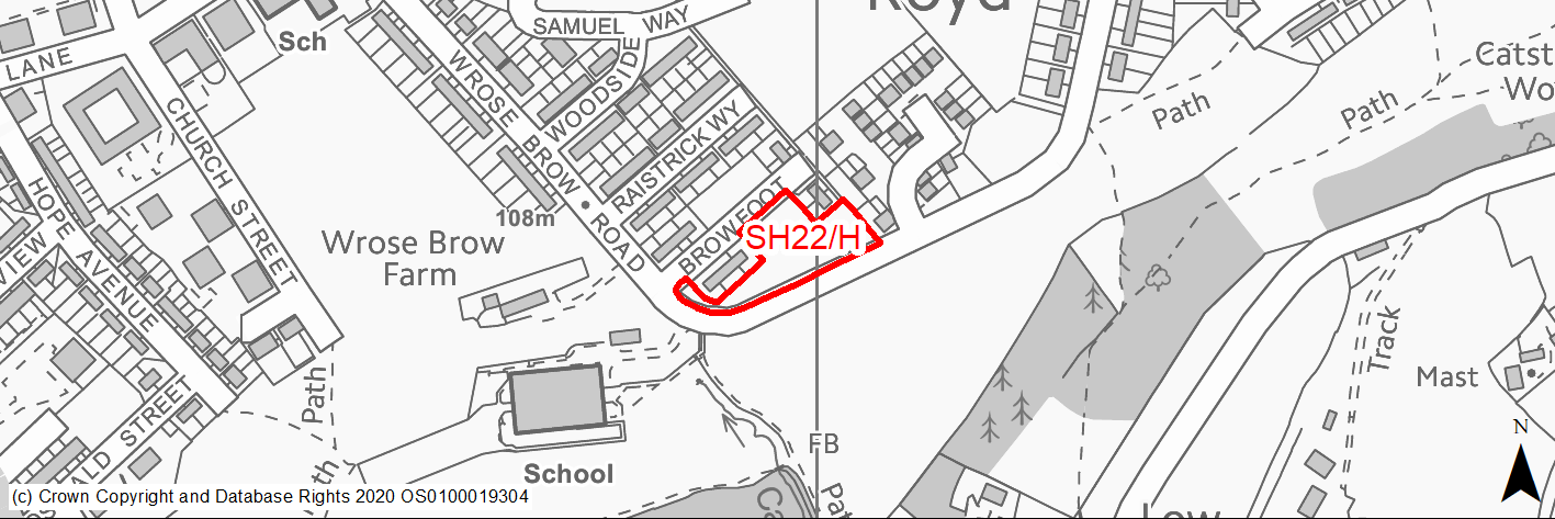
Site location
Regional City of Bradford- Shipley
Ward
Windhill and Wrose Ward
Site description
Largely unused but maintained amenity grassland bordering houses and lower part of slope alongside road.
Proposed Allocation
Housing
SHLAA referencce
SH/056
Indicative no. dwellings
15
Site area (Gross) (ha)
0.32
Ownership
Private
Delivery timescales
Developable (6-11 years)
Type (PDL/Greenfield)
Greenfield
Green Belt
No
Flood Zone
Flood Zone 1
Potential site access
Access to the site is available from Browfoot and Browfoot Road.
Public Transport Accessibility
Site within 400m of a bus stop (Leeds Road) and beyond 800m of nearest rail station (Shipley).
Sustainability Appraisal
The site could deliver a major positive effect for residents on the health SA Objective as a result of being within the target distances for all necessary health facilities.
Minor positive effects were predicted for nearly all other socio-economic themed SA Objectives due to the benefits of new residential development for the local economy as well as the location of the site in relation to transport links, local services and amenities, education facilities and employment areas.
No major adverse effects have been predicted for the site, but minor adverse effects were predicted for a range of natural environment themed SA Objectives, primarily as a result of the impacts of new development on a 100% greenfield site. The site is 35m north-east of a small waterbody, which could be adversely affected by construction and occupation of the site.
Habitats Regulations Assessment
This site falls within 7km of the South Pennine Moors SPA/SAC. A HRA must be undertaken to ensure there are no significant effects on these protected sites. Developments within these zones must comply with Policy SP11; a SPD is being produced to provide further guidance.
Green Belt
N/A – Site not within the Green Belt.
Constraints and Opportunities
• Site is within Green Infrastructure Corridor.
• Potential to include pedestrian link through the site linking the existing PROW to the north with greenspace to the south.
• Former Coal Mining High Risk Area Minerals - Coal Minerals Safeguarded Area.
Development considerations
• Development proposals will need to consider the potential presence of unstable land and any planning applications are expected to be accompanied by a Mining Risk Assessment Site within landfill 150m buffer.
Conclusion/Summary
This is a sustainably located greenfield site, which would deliver an estimated 15 dwellings.