
Draft Bradford District Local Plan - Preferred Options (Regulation 18) February 2021
East Morton
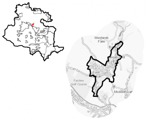
Introduction5.11.1 East Morton is rural village situated on the northern edge of the valley of the River Aire, which flows through the valley bottom around 700m to the south. It is around 2.8km to the north of Bingley town centre and 3.3km to the east of Keighley town centre. Riddlesden, a suburb of Keighley, and Crossflatts, a suburb of Bingley, are located around 530m and 330m to the west and south respectively, which the washed over Green Belt settlements of West Morton and Micklethwaite are 1km to the northwest and 250m to the southeast respectively. Morton Beck flows north to south through the eastern side of the village. It falls within the Keighley East Ward and the Keighley Parliamentary Constituency. Keighley Town Council acts as the administrative body for the village.
Figure 1: Location Plan
5.11.2 East Morton is primarily residential and functions as a commuter settlement with good connections to nearby towns and cities including Keighley, Bingley, Bradford and Leeds. There are a small number of local services and facilities to support the local population.
5.11.3 The village's resident population is 1,258. The largest majority (around 97%) of the population identify as being of white ethnicity, which is higher that the district, West Yorkshire and regional levels. Household composition is broadly similar to the district and regional picture, with the largest number of households (69%) consisting of one family. Of the total number of households in East Morton, around 19% consist those aged 65 and over, which is similar to the district level but below the sub-regional and regional levels.
Planning for Prosperity
5.11.4 The Local Plan settlement hierarchy identifies East Morton as a Local Service Centre. This means the emphasis is on a smaller scale of development comprising both market and affordable housing, together with the protection and enhancement of those centres as attractive and vibrant places and communities, providing quality of place and excellent environmental, economic and social conditions
Economy and Employment
5.11.5 East Morton has no residents living in the most 20% most deprived areas of England as ranked by the Indices of Multiple Deprivation.
5.11.6 Economic activity rates are generally positive for East Morton 77.1% of the resident population compared with 68.5% for the West Yorkshire average, with a higher percentage of full time employees and self-employed people than the regional comparisons. Annual household income of £44,900 is above the West Yorkshire at £34,499. Incomes are reflective of job types with higher percentages of the local people working in managerial or professional occupations.
5.11.7 East Morton is primarily residential and functions as a commuter settlement for nearby larger towns and cities. There are few employers of any note within the village and no employment areas, although the Bethel Hall Business Centre does provide serviced office space to rent on a short term basis. The nearest employment areas located in Bingley, Crossflatts and Keighley. Business Register and Employment Survey (BRES) data indicates that the three largest industry groups by workforce jobs (all people in employment) are business administration and support services (33.2%), construction (14.9%) and health (11.5%).
Retail
5.11.8 East Morton is not identified in the retail hierarchy. Retail provision within the village consists of a single, community run convenience store. Other retail services include a beauty salon and hairdressers, whilst there is also a public house. To access wider retail opportunities, residents have to travel to Bingley, Crossflatts, Keighley or Riddlesden.
Transport and Access
5.11.9 East Morton is located on the northern edge of key transport corridor running through the Aire Valley, providing good road and rail connections to nearby major towns and cities. It lies to the north of A650, the main route through the Aire Valley between Bradford, Keighley, North Yorkshire and East Lancashire. This gives access to other towns within Airedale including Keighley, Shipley, Silsden and Steeton with Eastburn as well as to Bradford and Skipton. It is connected to the A650 via Morton Lane and B6265. The latter route also gives access to the centre of Bingley as well as to Keighley. Other minor roads connect the village to Riddlesden and Silsden to the west and to Eldwick and Menston to the east.
5.11.10 The village lacks adequate public transport links. The nearest railway is located in Crossflatts around 2km to the south. It is a stop on the electrified Airedale line and provides frequent links to Bradford, Keighley, Leeds, Shipley and Skipton. Limited bus services operate through the East Morton, providing connections to Bingley and Keighley. Higher frequency services Bingley, Bradford, Keighley and Shipley can be accessed on the B6265 at Crossflatts. National Cycle Network Route 69 runs along the towpath of the Leeds and Liverpool Canal (located close to the southern edge of village), towards Bingley, Keighley, Saltaire, Silsden and Shipley as well as Bradford and Leeds. East Morton is not covered by an Air Quality Management Area (AQMA) and lies outside the proposed Clean Air Zone (CAZ).
5.11.11 In terms of car ownership, almost 93% of households have access to car or van. This is compared to just around 70% in West Yorkshire.
5.11.12 In relation to digital connectivity, average broadband download speeds in East Morton is just over 26 megabytes per second – below the West Yorkshire average, whilst there are no premises where speeds are below the Universal Service Obligation (USO)[1].
Planning for Homes
5.11.13 East Morton has 556 dwellings, the majority of which, 84.9%, are owner occupied. This above the average for West Yorkshire. The level of renting (15.1%) is below the West Yorkshire average (36.6%), with private and other forms of renting being largest proportion (see Figure 2).
Figure 2: Housing Tenure in East Morton
|
Owner occupied |
Owner-occupied: owned outright |
Owner-occupied owned: with mortgage or loan |
||
|
472 |
213 |
258 |
||
|
84.9% (West Yorkshire average = 63.4%) |
38.3% (West Yorkshire average = 28.8%) |
46.4% (West Yorkshire average = 34.1%) |
||
|
Owner-occupied: shared ownership |
Social rented households |
Rented from Council |
||
|
1 |
11 |
5 |
||
|
0.2% (West Yorkshire average = 0.5%) |
2.0% (West Yorkshire average = 18.8%) |
0.9% (West Yorkshire average = 12.5%) |
||
|
Rented from Housing Association or Social Landlord |
Rented from private landlord or letting agency |
Other rented dwellings |
||
|
6 |
64 |
9 |
||
|
1.1% (West Yorkshire average = 6.2%) |
11.5% (West Yorkshire average = 15.0%) |
1.6% (West Yorkshire average = 2.8%) |
||
|
Source: Census 2011 |
||||
5.11.14 The largest proportion (41%) of the village's housing stock consists of terraced dwellings, above the sub-regional average, whilst the number of detached dwellings is higher with proportion of semi-detached dwellings as well as flats being lower. Around 30% of the stock was built before 1900, with 16% being developed between 1900 and 1939. Around 54% have been constructed in the post war period (1945 to present). The average house price for East Morton is £199,500, compared with a West Yorkshire average of £183,194. This is reflected across all types of dwellings. The total affordability ratio between house prices and annual earnings which is usually used as a proxy for the number of years' worth of earning for a house deposit is 3.58 times compare to a West Yorkshire average of 2.96.
5.11.15 Delivering new housing is a key part of the overall development strategy for East Morton. It will ensure that the housing needs and aspirations of local people can be met, together with those of future residents, including the provision market and affordable housing. In addition, it will support the economy and reflect its role as a Local Service Centre.
5.11.16 Policy SP8 sets out a requirement of 10 dwellings that will be delivered in East Morton during the plan period. These will be delivered through a mix of committed sites (those under construction or have planning permission but have not yet commenced) and 1 new allocation which lies in the green belt. The Council will be supportive of additional proposals for new homes on additional small sites, particularly those that provide a redevelopment opportunity to bring forward land which has been previously used. Support will also be provided to developers who wish to redevelop larger sites and/or buildings for new homes not currently identified, subject to all relevant policies in the Local Plan..Table 1 below sets out the housing position for East Morton, which also include application of non-implementation of discount rates for planning permissions and allocations
Table 1: Summary of Housing Requirement and Supply
|
Housing Target |
10 |
|
Carried Forward Commitments |
6 |
|
Commitment Discounted by 10% |
5 |
|
Remaining Allocation Requirement |
5 |
|
Identified Allocations |
7 |
|
Allocations Discounted by 10% |
6 |
|
Total Supply Contribution from Allocations |
6 |
5.11.17 Once the commitments are discounted and removed from the supply this leaves a residual allocation requirement of 5 units. The evaluated total site supply of homes from preferred allocation sites equates to 7 units (6 after 10% discount for non-implementation is applied) which is slightly above the allocation requirement.
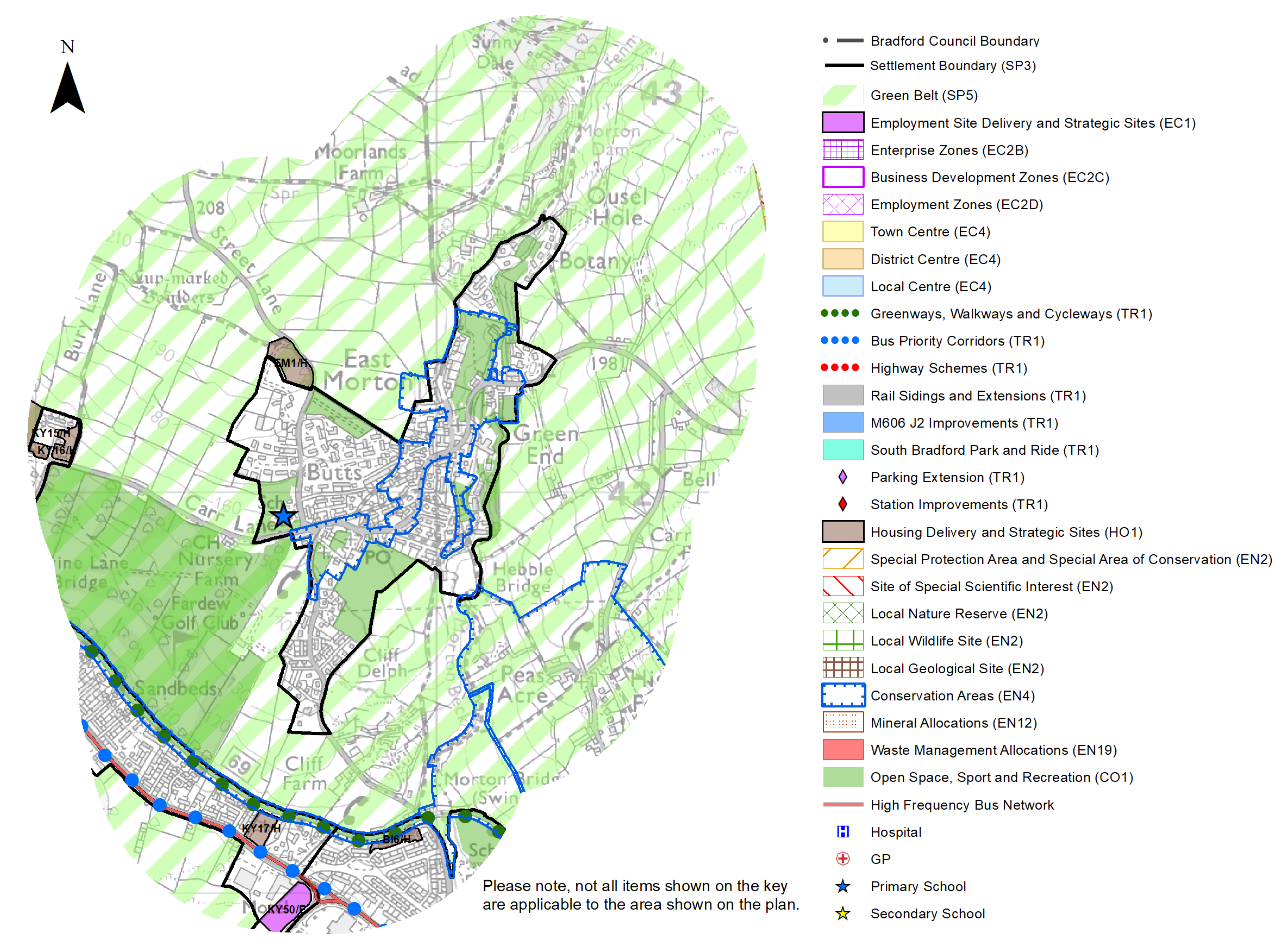
5.11.18 East Morton is reasonably constrained for allocations within the established settlement boundary and the local plan proposes to allocate one greenfield (green belt) site to meet the housing requirement for this area. This new site to meet East Morton's housing requirement is set out in Table A and identified on the Policies Map and on the Site Pro forma below. The development of the site should be in accordance with specified development guidelines and approximate site provision figures and all other relevant policies of this Local Plan. In delivering the target for new homes in East Morton it has been necessary to make some changes to the adopted green belt. Policy SP5 sets out The Councils approach and justification for green belt releases to accommodate new development and lists the sites proposed for allocation which current lie within or partly within the green belt
Planning for Places and Communities
Green Belt, Natural Landscape and Historic Character
5.11.19 East Morton is surrounded by Green Belt. This land falls within the Airedale Landscape Character Area. The prevailing landscape character is enclosed pasture (to the south, east and west) and upland pasture (to the north west and north east) as well as wooded valleys (to the north). The area has been assessed as having a moderate character, high historic continuity and being visible and enclosed. The Landscape Character Assessment notes that the upland pasture is very sensitive.
5.11.20 There is one designated Conservation Area within the village. This covers the historic core which includes Main Street, parts of Morton Lane, Little Lane and Green End Lane as well as part of the valley of Morton Beck. The Micklethwaite Conservation Area adjoins the settlement boundary to the south east, whilst the Leeds and Liverpool Canal Conservation Area is around 220m to the south. There a total of 12 Listed Buildings within the village, all of which are Grade II Listed. In addition, three Scheduled Monuments are located to the north west.
Green Infrastructure, Ecology, Open Space and Flood Risk
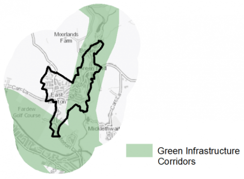
5.11.21 The village has a number of corridors and spaces that contribute towards the Green and Blue Infrastructure network. Key corridors include the valleys of the River Aire (a regionally important GI corridor) and Morton Beck that flows from north to south through the eastern edge of the East Morton. The Leeds and Liverpool Canal runs to the south. Figure 3 shows the location of the key green GI corridors.
Figure 3: Green Infrastructure Corridors
5.11.22 There is one biodiversity designation to the north of East Morton in the form of a Local Wildlife Site (LWS) – Sunnydale LWS. It is centred on the wooded valley of Morton Beck and Bradup Beck as well as a number of ponds/reservoirs. Part of this area is also identified as being ancient woodland. There are also a number of areas of priority habitats – deciduous woodland – to the north and east. The village is located on the southern edge of Rombalds Moor and the South Pennine Moors SPA/SAC (and SSSI) is around 580m to the east and north east. This places the whole settlement with 2.5km buffer of the SPA/SAC.
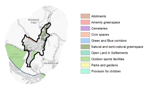
5.11.23 In addition, there are 10 open spaces, totalling around 36ha of land. Key sites within the village include East Morton Recreation Ground and East Morton Golf Course. The Open Space Assessment highlights that there are good levels of provision of most typologies with a good distribution of sites. However, it recommends that potential to provide some form of Park space within the settlement is examined.
Figure 4: East Morton - Open Space Overview
5.11.24 Fluvial flood risk is generally associated with East Morton Beck that flows through the eastern edge of the village. There are, however, identified areas of surface water flooding across the village associated with some the local street, surrounding fields and nearby watercourses.
Community Infrastructure – Education, Health and Utilities
5.11.25 There are also a number of local facilities within East Morton to support the local community. These include two places of worship, allotments, community hall, public house, recreation ground and a golf course.
5.11.26 The village is served by a single primary school – East Morton Primary School, which has a capacity for 210 pupils. Other primary schools are located nearby in Bingley, Crossflatts, Riddlesden and Keighley. The nearest secondary schools are situated in Bingley (Beckfoot School and Bingley Grammar School) and Keighley (University Academy Keighley). They have capacity for 4,388 pupils. Each includes 6th Form provision. In addition, local people have the opportunity to access post 16 education at several nearby Further Education colleges – Bradford College, Keighley College and Shipley College, whilst universities in Bradford and Leeds are also within reach
5.11.27 Pupils attainment levels at Key Stage 4 (GCSE) are above the West Yorkshire and national (England) average scores – 494.3 compare to 353.5 and 366.3 respectively. In terms of qualifications, almost 42% of the working age population have a Level 4+ qualification[2]. This is higher than both the West Yorkshire and national levels.
5.11.28 The village does not have a GP surgery or medical centre. It falls within the catchment of the two heath centres located in Bingley – Eldwick and Gilstead Health Centre and Canalside Healthcare Centre. The former has three GPs, whilst the latter consists of two medical practices with 20 GPs. A branch surgery is available in Crossflatts. Secondary (acute) health care provision is provided by Bradford Royal Infirmary and Airedale General Hospital.
5.11.29 Average life expectancy at birth for East Morton residents is 81 for men and 83 for women, which is similar to the West Yorkshire and England average. Healthy life expectancy is 67 for men and 69 for women.
5.11.30 When planning for the long-term development of East Morton, it is vital that new development is supported by the appropriate infrastructure. The capacity, quality and accessibility of services and facilities are all key components in ensuring people can enjoy living, working and visiting the area. The council will continue work with key infrastructure providers and others including the Local Education Authority, Clinical Commissioning Group and utilities providers to determine the impacts of future growth and development on local infrastructure capacity and provision. Further infrastructure details will be published through the Local Infrastructure Plan and as part of the Regulation 19 stage of the local plan.
|
Local Area Strategy and Plan – East Morton |
|
The key elements of the local strategy for East Morton include:
|
(14) Consultation Question 104
East Morton Local Area Strategy
The Local Plan sets out a series of local area strategy for East Morton.
Q. Please provide any comments you may have on the area strategies?
If you have an alternative to the approaches undertaken, please provide further details and evidence in support.
Preferred Site Allocations and Site Pro Formas
5.11.31 The preferred housing site allocation is detailed below in Tables A. This table is subsequently followed by a site pro formas for the preferred site allocation providing a summary of key site information and characteristics.
Table A: East Morton Housing Site - Preferred Allocations
|
Site Ref |
Site Name |
Dwellings / Other Uses |
|
EM1/H |
Street Lane |
7 |
|
Total |
7 |
(8) Consultation Question 105
East Morton Site Allocation and Site Pro Forma
The Local Plan sets out a series of preferred site allocations. If you wish to make representations on any of the sites proposed, please provide site reference and feedback under this question.
If you wish to propose an additional or alternative site(s) to the preferred allocations listed, please also provide a plan with a red line and any further details in support.
[1] Universal Service Obligation (USO) - download speeds at or above 10Mbit/s and upload speeds at or above 1Mbit/s including non-matched records and zero predicted speeds
[2] Level 1' qualifications are equivalent to a single O-level, GCSE or NVQ. 'Level 2' qualifications are equivalent to five O-levels or GCSEs. 'Level 3' qualifications are equivalent to two A levels. 'Level 4' qualifications are equivalent to degree level or higher.
(13) EM1/H - High Stead, Street Lane
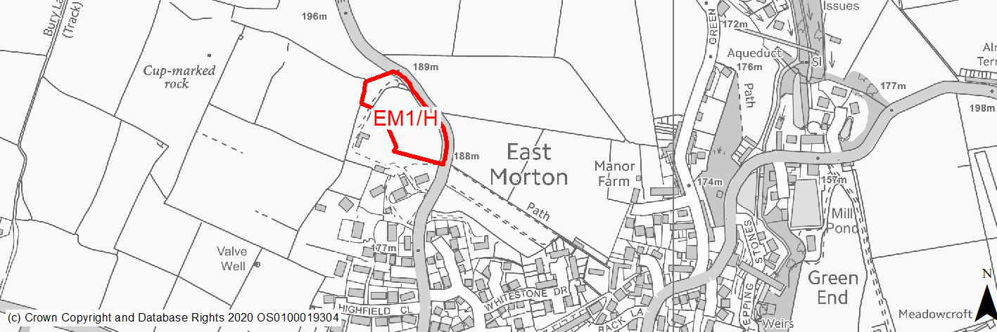
Site location
Local Service Centre - East Morton
Ward
Keighley East
Site description
The site consists of a mown field that appears to form the garden area/grounds for the large residential properties to the south. Mature trees are present along the boundary.
Proposed Allocation
Housing
SHLAA referencce
EM/007
Indicative no. dwellings
7
Site area (Gross) (ha)
0.79
Ownership
Private
Delivery timescales
Developable (6-10 years)
Type (PDL/Greenfield)
Greenfield
Green Belt
Yes
Flood Zone
Flood Zone 1
Potential site access
Access available from Street Lane at the north west corner of the site.
Public Transport Accessibility
Bus: The nearest bus stops are located 370m to the south of the site on Carr Lane. These provide 1/2 services per hour towards Cullingworth (eastbound) and Keighley (westbound).
Rail: The nearest railway station is Crossflatts (2km to the south east).
Sustainability Appraisal
Development at this site would be unlikely to result in a significant effect, either positive or negative, on any SA Objective.
Minor positive effects were predicted for most socio-economic themed SA Objectives due to the benefits of new residential development for the local economy as well as the location of the site in relation to transport links, local amenities, education facilities and employment areas.
Minor adverse effects were predicted for a range of natural environment themed SA Objectives, primarily as a result of the impacts of new development on a predominantly greenfield site.
Habitats Regulations Assessment
This site falls within 2.5km of the South Pennine Moors SPA/SAC a HRA must be undertaken to ensure there are no significant effects on these protected sites in terms of impact on supporting habitat which might be functionally linked to the SPA and recreational pressures. Developments within these zones must comply with Policy SP11; an SPD is being produced to provide further guidance.
Green Belt
Based on planning judgement the site has a low potential impact on the Green Belt.
• The site is located in low Green Belt parcel.
• The site makes a low contribution to the purposes of including land in the Green Belt.
• The site has low potential for sprawl and would have a moderate impact on openness.
• The site offers the opportunity to create a stronger Green Belt boundary than the existing boundary.
Constraints and Opportunities
• This is a greenfield site within the Green Belt, adjoining the settlement boundary for East Morton.
• It is within a self-contained Green Belt parcel. The site specific Green Belt assessment indicates that it has a low potential impact.
• It consists of an area of mown grass with a number of mature trees along the northern and eastern boundaries.
• The western-most section is with the outer consultation zone for a major high pressure gas pipeline.
• Scheduled Monument is around 90m to the west of the site.
• It is within the 2.5km buffer of the SPA/SAC.
• Access is available from Street Lane, however narrows close to the south east corner of the site.
Development considerations
• Provision of compensatory improvements to the surrounding Green Belt which may include improvements to the surrounding rights of way network to provide enhanced accessibility into the wider countryside.
• A sensitive design and layout will be required, including consideration of topography, building heights and appropriate screening to reflect the site’s location with the Green Belt and adjacent to the northern edge of the settlement as well as to mitigate any impact on the landscape.
• A heritage assessment may be required to determine potential impact on nearby Scheduled Monument.
• Seek to maintain the existing mature trees around the northern and eastern boundaries.
• Vehicular access is available from Street Lane, although consideration should be given to impacts the narrower section of this road as well as on the wider highway network. Consideration should also be given to pedestrian access.
Conclusion/Summary
This a sustainable site located adjacent to the settlement boundary for East Morton, close to local facilities including a primary school. It has a low potential impact on the Green Belt. The site would deliver an estimated 7 dwellings, but will required a sensitive design and layout to reflect its location, topography and any landscape impacts.