
Draft Bradford District Local Plan - Preferred Options (Regulation 18) February 2021
3.0 Strategic Policies
3.0.1 Strategies policies perform an important function in plan-making and set the overall pattern, scale and quality of development for the plan. It is important that the plan through strategic policies establishes the key strategic priorities building upon the vison and objectives for the area and a clear policy starting point for non-strategic policies.
3.0.2 The draft strategic policies presented in this section of the plan builds upon the strategic core policies within the adopted core strategy and consulted upon as part of the Core Strategy Partial Review in 2019. There are however a number of areas where due to the nature of the single plan structure and its direction of travel that the range and coverage of strategic policies has been strengthened, including:
- Setting SP1 - the presumption in favour of sustainable development – positioning this policy squarely within the strategic policy section and developing a focus more specifically on what sustainable development means within the Bradford District context.
- Refreshing and clustering the key development strategy policies at the front of the plan.
- Setting out more clearly strategic priorities for economic growth (SP6), housing growth (SP8) and planning for sustainable transport (SP7).
- Further developing and updating policies in relation to climate change, green infrastructure, the South Pennine Moors SPA, design and creating healthy communities.
- Introducing strategic policies for minerals and waste within the single plan structure.
3.0.3 The key policy areas covered in this section of the plan follow the overall format of the plan and include:
- development strategy - presumption in favour of sustainable development; spatial priorities; hierarchy of settlements; location of development and green belt.
- planning for prosperity – economic growth and planning for sustainable transport;
- planning for homes – housing growth
- planning for places and communities – climate change, environmental sustainability and resources uses; green infrastructure; South Pennine Moors SPA; strategic planning for minerals; strategic planning for waste; making great places (urban design); creating healthy places and working together.
3.0.4 The policies set out in this section should be read with the plan as a whole and in particular with section four (thematic policies) and where relevant the implementation, delivery and monitoring policies under section six.
List of policies:
- Policy SP1: Delivering Sustainable Development
- Policy SP2: Spatial Priorities
- Policy SP3: Hierarchy of Settlements
- Policy SP4: Location of Development
- Policy SP5: Green Belt
- Policy SP6: Economic Growth
- Policy SP7: Planning for Sustainable Transport
- Policy SP8: Housing Growth
- Policy SP9: Climate Change, Environmental Sustainability and Resource Use
- Policy SP10: Green Infrastructure
- Policy SP11: Protecting the South Pennine Moors SPA /SAC and their zone of influence
- Policy SP12: Strategic Planning for Minerals
- Policy SP13: Waste Management Infrastructure
- Policy SP14: Making Great Places
- Policy SP15: Creating Healthy Places
- Policy SP16: Working Together
DEVELOPMENT STRATEGY
3.1 Preferred Option – SP1: Delivering Sustainable Development
Introduction
3.1.1 As stated in the National Planning Policy Framework, the purpose of the planning system is to contribute to the achievement of sustainable development.
3.1.2 Achieving sustainable development involves pursuing net gains against each of the three key objectives – economic, social and environmental.
3.1.3 This policy is in two parts. Part A sets out the presumption in favour of sustainable development which must be followed in making planning decisions and Part B set out some of the key ways in which the Plan's policies and strategy will support the achievement of the three objectives.
The Presumption in Favour of Sustainable Development
3.1.4 The policies of the Local Plan provide a positive planning framework for guiding development and change in line with central government guidance. When considering development proposals, the Council will take a positive and proactive approach that reflects the presumption in favour of sustainable development contained in the National Planning Framework.
District Context and Supporting the Three Objectives of Sustainable Development
3.1.5 The economic element of sustainable development involves building a strong and competitive economy which this Local Plan is supporting through the identification of land for development of different types – for jobs, homes, services and infrastructure. Although the district has many attributes – a rich array of historic buildings, a tradition in manufacturing and industrial innovation, a young and diverse population and strong performance in new business start-ups it also faces considerable challenges. Some of its urban areas still display significant levels of deprivation and are characterised by relatively low land and property values.
3.1.6 Securing new development, investment and regeneration will not only provide the jobs and prosperity which will support local people, but will help to drive up land values increase market confidence, and render previously marginal schemes viable. In doing so the ability of the district to meet its needs within its urban areas, in the most sustainable locations, and via the recycling of brownfield sites and the intensification of land use will improve, and as it does so the pressure on scarce resources such as greenfield land will reduce. Policies SP6 and EC1 – EC4 are just some of the aspects of this plan which are supporting the economic aspects of sustainable development.
3.1.7 Strong gains in meeting the economic objectives of sustainable development should therefore also help in the achievement of some of the environmental aspects of sustainable development which include making effective use of (brownfield) land, protecting and enhancing the built and historic environment, and improving biodiversity. The Plan's spatial strategy which focuses the overwhelming majority of development on its main urban areas and its investment plans such as the delivery of mass rapid transit will help reduce the need to travel and achieve modal switch to public transport. When combined with the policies to improve the quality of new homes, direct new development sequentially to areas of the lowest flood risk, adopt low carbon technologies and support renewable energy, the District's ability to mitigate and adapt to climate change will be enhanced.
3.1.8 The policies and section of this Plan for the achievement of the environmental aspects of sustainable development include SP9, SP10 and EN1 to EN10. Environmental considerations are also interweaved throughout other policies and underpin local area strategies within Section 5 of the plan.
3.1.9 The social element of sustainable development involves supporting strong and vibrant communities through the provision of new homes, and promoting high quality design and places accessible to services and green spaces. The Council places considerable importance on promoting and improving health and well-being and this is reflected in the policies of the Local Plan which seek to protect and enhance green spaces, provide for sport and recreation and the Council's programmes and policies aimed at improving air quality such as the creation of Clean Air Zones.
3.1.10 Key examples of the way in which the Council are supporting the social aspects of sustainable development include the Creating Healthy Places Policy (SP15), Policies CO1-CO3 which are concerned with community facilities and resources and ID1 which support infrastructure delivery in its various elements.
3.1.11 The Council has adopted an approach to identifying, comparing and selecting development sites for allocation in this Plan which will support the three sustainable development objectives, in particular by allocating sites which will support regeneration and or the use of previously developed land and by ensuring that a sequential approach is taken which directs development away from areas of high flood risk.
Policy SP1: Delivering Sustainable Development
- The Presumption in Favour of Sustainable Development
- The Council will always work proactively with applicants jointly to find solutions which mean that proposals can be approved wherever possible, and to secure development that improves the economic, social and environmental conditions in the Bradford District and wider Leeds City Region.
- Planning applications that accord with the policies in this Local Plan (and, where relevant, with polices in Neighbourhood Plans) will be approved without delay, unless material considerations indicate otherwise.
- Where there are no policies relevant to the application or relevant policies are out of date at the time of making the decision then the decision maker will grant permission unless material considerations indicate otherwise – taking into account whether:
- Any adverse impacts of granting permission would significantly and demonstrably outweigh the benefits, when assessed against the policies in the National Planning Policy Framework taken as a whole; or
- Specific policies in that Framework indicate that development should be restricted.
- Supporting the Three Objectives of Sustainable Development
- The Council will through its plans, strategies, investment decisions and regeneration programmes support the achievement of the three sustainable development objectives. In particular:
- It will support the economic strength of the district by allocating sufficient land for new employment uses, by pursuing regeneration programmes and investment in its major centres, and by securing new and transformational investment in its infrastructure;
- It will meet the environmental objectives by the inclusion of suite of policies design to protect, conserve and enhance it environmental assets, by focusing development its main urban areas and by investing in public transport infrastructure in the process reducing the need to travel by car and reducing climate change emissions; and
- It will support the social aspects of sustainability by ensuring that sufficient land is allocated to meet the housing needs of the district's growing population, by promoting high quality design, by developing healthy places with access to a network of green spaces which enhance the built environment, provide opportunities for sport and recreation and by taking action to tackle air quality problems.
- In order to maximise the benefits of new development and reduce and mitigate the any adverse effects the Council will undertake an approach to site selection and allocation which:
- Applies a flood risk sequential approach to direct development to areas of lowest flood risk.
- Wherever possible maximises the use of previously developed land.
- Prioritises the allocation of sites which would assist in the regeneration of the plan area.
- Minimises the use of Green Belt land.
- Ensures that wherever possible development enables the enhancement of the built and natural environment and minimises the adverse environmental impacts of growth, in particular with regards to climate change, air quality, biodiversity and habitats.
Reasonable Alternatives – SP1: Delivering Sustainable Development
3.1.12 The reasonable alternatives considered:
- Retain the policy as included in the adopted Core Strategy;
- Delete the policy as the aspects are to some extent already covered by the NPPF and allow the spatial strategy and different policies which will contribute to the 3 objectives to speak for themselves.
3.1.13 The policy as drafted was chosen due the importance of emphasising how the achievement of the 3 objects are interdependent and to sign post some of the key challenges and the key initiatives and responses which the Local Plan and the Council are putting in place.
(200) Consultation Question 2
SP1: Delivering Sustainable Development
Policy SP1 (equivalent being Policy P1 in the adopted Core Strategy) was not included in the CSPR document as it was not proposed to form part of the partial review. However, the proposed amended policy expands on that included in the adopted Plan while still reflecting the provisions of the NPPF.
Q2. Please provide your comments for Policy SP1 and any suggested changes to the policy? If you would support an alternative to the Preferred Option, please provide further details and evidence to support this.
3.2 Preferred Option – SP2: Spatial Priorities
Introduction
3.2.1 The District needs, over the long term, to capitalise on existing strengths, unlock potential and to improve the quality of life, prosperity and health of current and future generations. Economic, social and environmental progress has been uneven across the District. Continued unbalanced development will threaten the future quality of life and competitiveness of the District – with 'overheating' of already successful areas (through congestion, and reduced environmental quality) and a 'failure to capitalise' on the latent strengths of under-performing areas. The growth of the District's economy prior to the pandemic has been fuelled by the significant expansion of knowledge, business and financial services industries as part of the 'Leeds Economy'. Maintaining and sharing out the benefits of this growth is a key Leeds City Region challenge.
3.2.2 The District is large and diverse and in terms of land area it is mainly 'rural' in character. The City of Bradford and the towns of Ilkley, Keighley and Bingley need to provide a strong focus for local communities, in terms of service provision and employment and housing opportunities. Other settlements have the potential to grow in a managed and sustainable way in particular the Local Growth Centres derived in Policy SP3. This will help to promote greater self-sufficiency in rural areas.
3.2.3 The District offers a high quality environment, including green flag award winning public parks and gardens and moorland countryside. The character and qualities of the countryside needs to be protected and enhanced in their own right, as well as for the important species and habitats they include. It also offers a key opportunity to stimulate new economic activity, including tourism, particularly for more isolated and peripheral rural areas.
3.2.4 More efficient low carbon and active travel movement patterns will be required to support a competitive economy, healthier lifestyles and a quality environment. Many parts of the District continue to need to be restructured and the legacies left by past industrialisation addressed. The industrial age has provided a very rich and distinctive character and heritage to the District and had a marked effect on communities and the physical environment.
Unlocking Potential
3.2.5 Bradford's wider economic strategy is clearly focused upon unlocking the economic potential of the District, with its young and enterprising population, distinctive and varied architectural, heritage and cultural assets, sectoral strengths and worldwide connectivity. The global pandemic with its significant impact on human health has however also emphasised how fragile economic growth can be and also raised questions about the connections between economic growth and the environment with reflections on a move towards a greener and more resilient economy. The pandemic has also amplified the diverse range of health and economic challenges across the District and within communities and shone a spotlight on the need for good quality housing, open spaces and active travel options.
3.2.6 Noting that the findings from the 'Special Report on Global Warming of 1.5°C', published by the Intergovernmental Panel on Climate Change in October 2018, and in line with other local authorities, the Council declared a Climate Emergency in January 2019 - there are clear links to be made between economic recovery and a lower carbon future. Our spatial priorities within the Local Plan therefore include a refreshed and more detailed focus upon clean transport, green infrastructure; biodiversity, open spaces better, designed homes, workplaces and neighbourhoods; low carbon and renewable energy; local skills, inclusive growth, green jobs / clean growth and better connected economic space.
Communities and Local Planning
3.2.7 This integrated Local Plan sets a course of direction linking planning policy to places with a focus upon planning at a local area level and with a view to develop this further. Planning for housing and economic growth holistically within the wider context of local communities; access to local services and facilities and preserving and developing local assets, including valued open spaces, ecology and green infrastructure is a fundamental spatial focus for the plan. Ensuring new development is well designed at a neighbourhood and individual scheme basis is very important and links to the refreshed set of design policies within the plan and adopted Homes and Neighbourhoods Guide SPD.
Innovation and Smart Planning
3.2.8 Bradford has a strong history of innovation and is part of smart city initiatives to attract technological entrepreneurs to the district and create new business opportunities. The application of data and intelligence to the development and management of the physical environment has the potential to improve our understanding and approach to managing transport and movement, waste, air quality, resource and water use and early detection of flood risk, together with supporting innovation in energy, housing and the efficient use of space.
3.2.9 The plan has a focus upon embedding 'smart planning' within policy and ensuring that new development in housing and employment is future fit and adaptable. Innovation in the delivery of housing - through modern methods of construction and high environmental standards is encouraged through various policies to further support the culture of innovation within the District and set new benchmarks of quality and originality in place-making.
Investment, Renewal and Sustainable Growth
3.2.10 The District has suffered from the decline in its traditional industries which resulted in significant economic change. This has contributed to more concentrated levels of deprivation. There is a major opportunity to further strengthen and renew the Regional City of Bradford and Principal Towns as the prime focus for economic activity. Much remains to be done to create more attractive living and working environments.
3.2.11 There is a clear thread running through the Local Plan of supporting the renewal and regeneration of our urban areas and brownfield sites. Bradford City Centre continues to be a particular focus for new growth with a proposed extension to the city centre (Southern Gateway) stimulated in part by potential opportunities for a major investment in high speed rail and a new mass transit system, together with improved active travel connections and a coordinated approach to city masterplanning - supporting housing, jobs, open spaces, services and much more. The focus is very much upon creating a more liveable city with diverse opportunities for housing within a high quality and safe environment.
3.2.12 Spatial priorities are also focused upon supporting key hubs, these comprise a series of networks or convergence of functions of the individual towns and local centres where the growth of the local economy, an increase in the supply of housing and the development of the social structure of the community are all interrelated. The various components of the settlement when considered and addressed as a whole, can lead to a more balanced and sustainable centre. These locations, through their connected activity, will provide an important focal point for services, facilities and employment and cultural activity, improving their performance, management and attractiveness.
3.2.13 Low levels of education attainment and lack of basic and advanced skill requirements remain problems in parts of the District. Significant levels of deprivation are concentrated in many of the urban parts of the District, especially in the City of Bradford and Keighley. In rural areas, isolation and limited access to services also generate significant issues. Overall, there is a need for a more interventionist based approach to connect people in need with opportunities and reduce exclusion and inequalities. Studies show that accessibility to opportunities, facilities and services has a key influence on people's quality of life. The voluntary and community sector also have an essential part to play in helping to address exclusion, inequality and crime in the District. A good quality environment is critical to the social, economic and environmental wellbeing of the District.
3.2.14 Pressures on our environmental assets and resources are likely to increase with the demands for growth. The District is particularly susceptible to a number of environmental threats such as flooding, atmospheric pollution and soil degradation, as well as the multi-faceted impacts of climate change. Positive, responsible environment management will be vital to safeguard and improve our environment, including air quality, and the well-being of people in the District.
Policy Directions
3.2.15 The adopted Core Strategy places a strong emphasis upon transformation and change. It is proposed to continue to sharpen our focus as set out previously through the Core Strategy Partial Review (CSPR) and include further clarity over key growth and regeneration priorities so that there is a clear line between strategic policy, lower tier policies and the approach to local areas and allocations as set out in Section 5 of the plan.
3.2.16 Where people live, learn and work are vitally important to health and wellbeing. The neighbourhoods, homes, schools, streets and workplaces that we are born, work, live and socialise in have a significant influence on many factors that affect wellbeing. The Bradford District has significant public health challenges and the local plan can play a major role in helping address these complex issues. These remain a strong theme throughout the plan.
3.2.17 In reflection of some of the themes outlines above, some limited aspects Policy SP2 have been updated since the CSPR to reflect a stronger focus upon local communities, the economy, active movement and high quality infrastructure.
Policy SP2: Spatial Priorities
- Seek to manage the delivery of development and change in conjunction with local communities and stakeholders to meet the needs of the District to 2038 in order to deliver the spatial vision and objectives and achieve sustainable development in line with National Planning Policy Framework and Policy SP1a/b.
- Planning decisions as well as plans, strategies, programmes and investment decisions should seek to:
- Transform economic, environmental, physical and social conditions of the District, in particular the Regional City of Bradford including Bradford City Centre, Shipley and Canal Road Corridor, key regeneration areas, including Manningham and Holme Wood, and Leeds Bradford Corridor as well as Keighley Airedale, and Shipley.
- Manage and spread the benefits of inclusive and sustainable growth of the Bradford economy as part of the Leeds City Region.
- Enhance the role of Bradford District within the wider Leeds City Region as a key business location with a good supply of labour, housing, services including retail and associated community provision.
- Optimise the opportunities provided by the close proximity of Leeds Bradford International Airport as an international business gateway for the District and the region and build upon sectoral expertise, worldwide connectivity and tourism.
- Support, protect and enhance the roles of the Principal Towns of Ilkley, Keighley and Bingley and the Local Growth Centres of Burley in Wharfedale, Menston, Queensbury, Thornton, Silsden and Steeton with Eastburn as hubs for the local economy, housing and community and social infrastructure and encourage diversification of the rural economy of the District.
- Support the Local Service Centres as defined in Policy SP3 in providing for homes and local services.
- Protect and enhance the District's environmental resources for all including areas of international and national importance, such as the South Pennine Moors, the character and qualities of the Districts heritage, landscape and countryside and maximise the contribution they can make to the delivery of wider economic and social objectives.
- Ensure a move towards a green economy and a resilient lower energy and low carbon future and first minimise the District's exposure to environmental threats and then mitigate environmental threats to the District through adaptation and building resilience.
- Avoid increasing flood risk, and manage land and river catchments for flood mitigation, renewable energy generation, biodiversity enhancement and increased tree cover.
- Ensure that transport management and investment decisions support and help deliver the spatial strategy, in particular sustainable patterns of development, inclusive access to jobs and facilities, and shift to sustainable and active forms of movement.
- Ensure that developments are of high quality and well designed and that they contribute to inclusive built and natural environments which protect and enhance local settings, and heritage and reinforce or create a sense of local character, community and distinctiveness, supported by high quality infrastructure.
- Ensure that the local plan and well-designed, high quality development contributes to the creation and delivery of healthy places, improving people's health and wellbeing and helping reduce health inequalities, by planning sustainable, resilient and well-connected places where people want to live and work.
Reasonable Alternatives – SP2: Key Spatial Priorities
3.2.18 The reasonable alternative considered are part of this policy formation included:
- Updating the policy but considering a less extensive range of changes – does not deliver a comprehensive strategic approach to a key overview policy.
(199) Consultation Question 3
SP2: Key Spatial Priorities
The preferred policy includes a slight update to the revisions indicated as part of the CSPR but maintain keys themes.
Q3. Please provide your comments for Policy SP2 and any suggested changes to the policy? If you would support an alternative to the Preferred Option, please provide further details and evidence to support this.
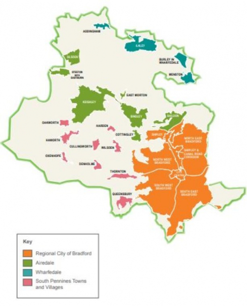
3.3 Preferred Option – SP3: Hierarchy of Settlements
Introduction
3.3.1 The use and articulation of a settlement hierarchy in guiding and controlling the distribution of growth and development is a well-established planning tool with its roots in the RUDP and historically the Regional Spatial Strategy (RSS) and plays a major role in establishing a sustainable pattern of growth and development across the district. While broadly in line with the approach of the RSS, the Core Strategy made some adjustments to the overall settlement hierarchy approach to include Bingley as a Principal Town and introduced a tier of 'Local Growth Centres' between the Principal Towns and much smaller Local Service Centres following a detailed settlement study and the practicalities of the land supply situation at the time.
3.3.2 Policy SP3 essentially carries forward and slightly refreshes the principle themes within SC5 from the Core Strategy and seeks to both identify the key differences in scale and nature of development envisaged between the different parts of the district and give a more spatially specific outline of the key priorities for plans, strategies and investment decisions at each tier of the settlement hierarchy. Section 5 of the plan further builds upon the settlement and area focus providing additional context and strategy to support site allocations for housing and employment, as well as identifying important areas to protect, such as valued open spaces and environmental assets.
Regional City of Bradford
3.3.3. Policy SP3 applies to the Regional City of Bradford including Shipley and Lower Baildon as shown on the Key Diagram. The Regional City of Bradford including Shipley and Lower Baildon will provide the prime focus of new housing development and of employment, shopping and health, leisure, business and public services in the District. Focusing development, investment and activity on the Regional City of Bradford, Shipley and Lower Baildon offers the greatest scope to:
- re-use land and buildings;
- make the most of existing infrastructure and investment;
- lower carbon emissions and reduce the need to travel;
- maximise accessibility to services and facilities, and
- encourage more active travel over short distances and encourage the use of public transport.
3.3.4 Approximately 72% of the District's housing growth is planned for the Regional City which is a slight increase from 70% as identified in the Core Strategy Partial Review (CSPR) and up from 66% in the adopted Core Strategy. The industrial legacy in the District presents both major opportunities and significant constraints. Over the last century, urban areas have often been neglected, with a relatively slow pace of renewal and change often reflective of land use values and viability. Progress has been made over recent years, such as increased city centre living and more brownfield development, but there is still much to do.
3.3.5 The often degraded fabric of urban areas requires a comprehensive and clear strategy to ensure urban renewal and living appeals to a wide and diverse range of residents, not only in terms of urban housing types but also the quality of the wider environment and public realm- open spaces, services and facilities, places for recreation and leisure, safe and healthy streets which are well managed with a sense of place and quality.
3.3.6 The District's industrial legacy remains a powerful influence on the nature of its people and communities. It has shaped the fundamentals of the Regional City, Principal Towns and smaller settlements of the District and has left a positive legacy in terms of fine civic buildings, parks and gardens and a culture of enterprise and innovation, but there is a real need to reinvigorate our urban vision for living, building upon the best of the past, but tackling the challenges of the here and now in terms of regeneration, climate change, public spaces, green infrastructure, economic growth and investment, sustainable transport and well-designed housing in communities where people and families want to live and invest. A better connected, greener and more sustainable Bradford. The Regional City is well placed to maximise opportunities for regeneration and renewal led growth unlocking economic and housing potential linked to strategic transport infrastructure and an extended city centre (Southern Gateway) with further directions and vision set out in the local area and allocations (Section 5) element of this plan.
Principal Towns
3.3.7 The Principal Towns within the District are Ilkley, Keighley and Bingley, as identified on the Key Diagram. They vary in size and function but fulfil a District wide significant role as service, employment and transport hubs for their surrounding areas. While on a smaller scale than that within the Regional City, these towns will be a main focus for the provision of new housing and will provide an important focal point for services, facilities and employment – complementing and supporting the roles of the Regional Cities of Bradford and Leeds. This focus supports a pattern of service centres to meet the needs of rural areas and support a balanced pattern of development across the District. Relative to the overall number of settlements in the District, a local development focus on these three Principal Towns provides an efficient and concentrated approach to investment and service delivery.
3.3.8 As significant towns in their own right it is important that public transport services enable local communities to efficiently access their services, facilities and employment opportunities. Transport is fundamental in enabling settlements to function as a network of different places fulfilling different roles and providing different opportunities. Their town centres provide a key focus for commercial, service and cultural activity. Improving the performance, management and attractiveness of town centres is important to the future roles of towns across the District. It is important that while growth and change is supported within the Principal Towns, the character and distinctiveness of them is protected and enhanced – for economic, environmental and social reasons. Open spaces within settlements, their edges and landscape settings and historic buildings, areas and street patterns all have a strong influence on their character and distinctiveness.
Local Growth Centres
3.3.9 The Local Growth Centres within the District are, Burley in Wharfedale, Menston, Steeton with Eastburn, Silsden, Queensbury and Thornton, as identified on the Key Diagram. They are the most sustainable local centres and vary in size and function but fulfil a significant role as settlements along key public transport corridors providing attractive and vibrant places for their surrounding areas. These centres will provide an important focal point for affordable housing and market housing needs as well as employment and associated community facilities - complementing and supporting the roles of the Regional City of Bradford, Sub Regional Town of Halifax and the Principal Towns of Skipton, Ilkley, Keighley and Bingley.
3.3.10 This focus supports a pattern of service centres to meet the needs of rural areas and support a balanced pattern of sustainable development across the District with high quality links to Halifax, Skipton and Leeds beyond the District boundary. Despite their smaller scale, the levels of housing development envisioned within the Core Strategy in these Local Growth Centres means that sustainable patterns of development will be dependent on maintaining and where possible improving public transport services and other infrastructure. This will enable local communities to access services and employment opportunities both within the Local Growth Centres and within neighbouring larger settlements and centres. It is important that the growth and change which occurs within the Local Growth Centres is achieved without detracting significantly from their character and distinctiveness. Elements that should be protected wherever possible include valued open spaces within settlements, and historic buildings and their settings. It is also important that the development which does occur within Local Growth Centres makes maximum contribution to meeting the needs of those local communities and in supporting and enhancing the viability of the local services.
Local Service Centres and Rural Areas
3.3.11 The District's Local Service Centres and rural areas form the fourth element of the settlement hierarchy and are shown on the Key Diagram. A reduced scale of growth, compared to urban areas, forms the overall approach in the settlements of Addingham, Baildon, Cottingley, Cullingworth, Denholme, East Morton, Harden, Haworth, Oakworth, Oxenhope and Wilsden. Local Service Centres are the villages that provide services and facilities that serve the needs of, and are accessible to, people living in the surrounding rural areas. Local Service Centres include a range of settlement types and sizes.
3.3.12 The Local Plan seeks to prevent the unnecessary dispersal of development to smaller settlements and open countryside while allowing for limited types of development in the countryside in line with NPPF. Each of the local service centres has a defined level of housing growth in the Local Plan, which takes into consideration the scale of the settlement and land opportunities, balancing a modest level of growth to help sustain and support local services and facilities while also providing a greater range of local housing including affordable housing. Figure 3.3 below illustrates the District's settlements and their respective sub-area groupings.
Figure 3.3: The District Settlements
3.3.13 Many of the issues that affect rural areas also affect the District's urban areas. Addressing common issues of exclusion and deprivation requires a range of actions – one size will not fit all. Rural areas contribute to the prosperity of the whole District, therefore it is key to recognise and improve the relationships between our rural and urban areas, and ensure that urban-based services address exclusion and deprivation in their rural hinterlands.
3.3.14 Approximately 66% of the District is rural in nature and home to 20% of the District's population. It is important that we harness the strengths and resources of rural areas to the benefit of the District as a whole and to develop a viable future for rural communities. There is a need to ensure that the countryside is enhanced and sustains the natural, cultural and historic environment of the District. Haworth and Bronte Country to the west of the District are of significant cultural significance for example. Using appropriate materials and a good quality of design is important to safeguarding and enhancing local character. Effective environmental stewardship is vital ensuring that local people have access to local services is important to the quality of life experienced by rural communities.
Policy SP3: Hierarchy of Settlements
Regional City
- The Regional City of Bradford (with Shipley and Lower Baildon) will be the prime focus for housing, employment, shopping, leisure, education, health and cultural activities and facilities in the District. To support this role, the Regional City will see the greatest proportion of development and growth as set out in policies SP6 and SP8.
- The Regional City of Bradford (with Shipley and Lower Baildon) will continue to be transformed into attractive, cohesive, inclusive and safe places where people want to live, work, invest, and spend time in. Planning decisions as well as Plans, strategies, investment decisions and programmes should:
- Achieve a wide range of quality housing and employment to meet the needs of communities and employers.
- Develop a strong sense of place which reinforces the distinct identity of the area through well-designed public realm and buildings within a clear framework of accessible and well connected routes and spaces.
- Create new and improve existing open space, green areas, networks and corridors including the urban fringe to enhance biodiversity and recreation.
- Maintain and strengthen the identity and roles of Bradford City Centre and Shipley Town Centre as accessible and vibrant focal points for high trip generating uses which support both the day and evening economy.
- Improve public transport systems and services and increase opportunities for walking and cycling throughout the Regional City and to other settlements.
- Improve connectivity within the District, to the adjoining Regional City of Leeds and wider conurbations through West Yorkshire and beyond to access housing, employment and community facilities.
- Support the regeneration and renewal of the Regional City as a place to live and invest.
Principal Towns
- Ilkley, Keighley and Bingley will be the main local focus for housing, employment, shopping, leisure, education, health and cultural activities and facilities.
- The roles of Ilkley, Keighley and Bingley as accessible and vibrant places to live, work and invest should be enhanced.
- Biodiversity, landscape and heritage assets define the character and setting of the Districts principal towns. Potential for growth will be informed by the existing scale of the settlement, the contribution made by environmental assets and the importance of these assets and flood risk issues. Planning decisions as well as plans, strategies, investment decisions and programmes should:
- Achieve a high standard of design that protects and enhances settlement character.
- Improve accessibility from surrounding areas and improve their function as hubs for transport services and interchange.
- Improve public transport and active travel links between Ilkley, Keighley, Bingley, Regional Cities of Leeds and Bradford.
- Ensure that they provide the main focus for employment development in rural areas.
- Enhance the renewal, vitality and viability of their town centres.
- Create new and improve existing open spaces, green areas, networks and corridors including the urban fringe to enhance biodiversity and recreation.
Local Growth Centres
- Burley in Wharfedale, Menston, Queensbury, Thornton, Steeton with Eastburn and Silsden are the most sustainable local centres and accessible to higher order settlements such as Bradford, Keighley and Ilkley. All are located along key road and public transport corridors and should therefore make a significant contribution to meeting the District's needs for housing, employment and provide for supporting community facilities.
- The roles of Burley in Wharfedale, Menston, Steeton with Eastburn, Silsden, Queensbury and Thornton as accessible, attractive and vibrant places to live, work and invest should be enhanced. Planning decisions as well as Plans, strategies, investment decisions and programmes should seek to:
- Achieve a high standard of design that protects and enhances settlement and landscape diversity and character.
- Improve accessibility from surrounding areas and improve their function as hubs for transport, local facilities, affordable and market housing needs.
- Develop new and improved public transport and active travel links between Local Growth Centres and with Regional City of Bradford and the Principal Towns of Ilkley, Keighley and Bingley and also the Regional City of Leeds and the Principal Towns of Halifax and Skipton.
- Ensure that they support economic diversification.
- Enhance the vitality and viability of Local Growth Centres.
- Create new and improve existing open spaces, green areas, networks and corridors including the urban fringe to enhance biodiversity and recreation.
Local Service Centres and Rural Areas
- Within the Local Service Centres of Addingham, Baildon, Cottingley, Cullingworth, Denholme, East Morton, Harden, Haworth, Oakworth, Oxenhope, Wilsden the emphasis will be on a smaller scale of development comprising both market and affordable housing, together with the protection and enhancement of those centres as attractive and vibrant places and communities, providing quality of place and excellent environmental, economic and social conditions. Planning decisions and plans, strategies, investment decisions and programmes should seek to:
- Achieve a high standard of design that protects and enhances settlement and landscape diversity and character.
- Support innovative means of accessing and delivering services and the reduction of isolation particularly through the development of high speed broadband access in rural areas.
- Retain and improve local services and facilities, particularly in Local Service Centres.
- Support economic diversification, including leisure and tourism offer, live work and home working.
- Create new and improve existing open spaces, green areas, networks and corridors including the urban fringe to enhance biodiversity and recreation.
- Improve public transport and active travel links between Local Service Centres and to the Regional City of Bradford, Principal Towns of Ilkley, Keighley and Bingley, the Regional City of Leeds, and the Principal Towns of Halifax and Skipton.
Reasonable Alternatives – SP3: Settlement Hierarchy
3.3.15 The reasonable alternative considered for this policy focused upon a more limited range of changes, which did not align fully to the changing context within which the policy is drafted.
(218) Consultation Question 4
SP3: Settlement Hierarchy
The preferred policy includes a range of limited changes as detailed in the drafting with a stronger focus upon investment, regeneration, design quality and sustainable transport and movement.
Q4. Please provide your comments for Policy SP3 and any suggested changes to the policy? If you would support an alternative to the preferred option, please provide further details and evidence to support this.
3.4 Preferred Option – SP4: Location of Development
Introduction
3.4.1 The CSPR provided a series of updates to Policy SC5: Location of Development which supported by a number of thematic policies on housing and economy provided a clear framework and sequential approach within the local plan to the supply of development sites. It placed a strong emphasis upon the use of deliverable and previously developed land and the use of existing urban areas, with a focus upon minimising the amount of dispersal of development to edge of settlement locations and the need for changes to Green Belt.
3.4.2 The adopted Core Strategy policy placed an emphasis upon prioritising between 'local Green Belt' and larger urban extensions. The policy was redrafted in the CSPR to focus upon limited Green Belt release without specific reference to the potential scale of the Green Belt release site. Other major changes to the policy related to a separation and reordering within the movement hierarchy to further emphasise the importance of active travel and clarification on the definition of the road hierarchy, in line with updated transport policies.
3.4.3 The revised strategic policies SP2 and SP3 within the Local Plan envisage a relatively concentrated pattern of development across the District focused primarily but not exclusively on the Regional City of Bradford, together with the Principal Towns of Ilkley, Keighley and Bingley, and smaller levels of growth within Local Growth Centres and Local Service Centres. Policy SP4 builds upon the preferred revisions to the policy (originally labelled SC5 as set out in the CSPR) and sets a series of locational priorities to support policies SP2 and SP3 for allocating sites within the Local Plan. The policy is intended to align with the new strategic policies SP6 and EC1 (Economic Growth) and SP8 and HO1 (Housing Growth) which set further clear directions for growth.
Sequential Approach
3.4.4 A sequential approach is fundamental to allocating sites and defining growth areas and will help:
- deliver the growth, renewal and regeneration focus set out through the hierarchy of settlements under Policy SP3;
- make better use of underused land and buildings and existing infrastructure and services;
- strengthen the commercial and cultural roles and vibrancy of the City and the Principal Towns, and
- minimise both the need to travel and to develop greenfield sites.
3.4.5 While there has been considerable success in re-using brownfield sites in the District over recent years, the challenges in maintaining this in future years with much higher levels of housing need will be much greater. Policy SP4 will therefore ensure that the opportunities that do exist to re-use and recycle deliverable sites within the existing built up area are maximised.
3.4.6 Policies SP2 and SP3 promote transforming urban areas of the City and the Principal Towns. It is important that valuable habitats and open spaces are retained within settlements and that a vibrant mix of land uses is maintained – the achievement of housing growth should not be at the expense of driving out important employment and community uses from the centre of the Regional City and Principal Towns. Housing growth also needs to reflect local needs and be of high quality. Avoiding significant adverse environmental impacts and promoting the integration of transport and land use are key factors in achieving more sustainable development.
Transport and Movement
3.4.7 Policy SP4 requires a more transport orientated approach to development, whether sites are in inner or peripheral areas. This approach places an emphasis on public transport (planned or existing) routes as a key factor for locating or intensifying development. This also provides the scope to foster 'walkable' 15 minute active neighbourhoods clustered along transport corridors. Public transport corridors should radiate from within settlements to link into main centres of activity and provide the scope for prioritised, high quality and efficient public transport services. Railway stations, park and ride sites and locations along bus routes can all act as 'nodes' for development to encourage a greater use of public transport.
3.4.8 In terms of any peripheral growth areas public transport routes can provide a structure to safeguard or create green wedges of open space or countryside. The transport orientated approach does not seek to 'eliminate' the car – but balance and reduce its use. Multi-commuting, the decentralisation of activities and greater specialisation and increased leisure time are all inducing growth in the need to travel. This strategic policy, along with policies SP7 and SP15 seeks to ensure that more of these journeys are made by public transport, foot and cycle.
3.4.9 At a settlement and local area level Section 5 of the plan sets out broad spatial strategies, which build upon the focus within policies SP2 and SP3 together with other relevant strategic and thematic policies.
Policy SP4: Location of Development
- The Local Plan will allocate sites by giving:
- First priority to the efficient and effective re-use of deliverable and developable previously developed land and buildings provided that it is not of high environmental value and more efficient and effective use of existing developed areas within the City of Bradford, the Principal Towns of Ilkley, Keighley and Bingley, the Local Growth Centres and the Local Service Centres.
- Second priority to sustainable Greenfield opportunities within the settlements.
- Third priority to the release of Green Belt land as set out under Policy SP5.
Subject to the above:
- The Local Plan will adopt an accessibility orientated approach to ensure that development:
- Makes the best use of existing transport infrastructure and capacity to enhance the quality and efficiency of public transport.
- Maximises accessibility by walking, cycling and creating green corridors.
- Supports the use of public transport and meets minimum accessibility standards as set out in the transport policies in this plan and Appendix 6.
- Takes into account capacity constraints and deliverable improvements, particularly in relation to improving and development of the Strategic Road Network including junctions and schemes.
- Maximises the use of rail and water for uses generating large freight movements.
Reasonable Alternatives – SP4: Location of Development
3.4.10 The reasonable alternatives considered and discounted for this policy include:
- Do not review policy – policy remains unchanged from the adopted core strategy policy – on review it was considered that there was no clear rationale for applying a prioritisation to local Green Belt release ahead of larger urban extensions; the reordered movement hierarchy reflects changes made to other policy areas to reinforce the carbon reduction and air quality improvement priorities. Changes to the road hierarchy are in line with other updated policies.
- Undertake more limited changes to the policy and retain current Green Belt prioritisation - this may limit the opportunities for larger urban extensions to deliver ahead of smaller 'local' Green Belt development opportunities.
- Undertake more limited changes to the policy and delete the Green Belt prioritisation element but retain movement and road hierarchy as drafted in adopted core strategy policy – does not align fully with updated transport and other policies, focused upon carbon reduction and air quality improvements.
- Variations on limited changes.
- Delete individual policy and integrate within other policies – the policy sets out a clear sequential framework for development which can be read across the Local Plan.
(210) Consultation Question 5
SP4: Location of Development
The preferred policy primarily roles forward changes to Green Belt site prioritisation and a reordered movement hierarchy as set out in the CSPR.
Q5. Please provide your comments for Policy SP4 and any suggested changes to the policy? If you would support an alternative to the Preferred Option, please provide further details and evidence to support this.
3.5 Preferred Option – SP5: Green Belt
Overview
3.5.1. The Government attaches great importance to Green Belts with the general extent of Green Belts across the country already established. The Bradford District Green Belt evolved via a number of local area plans but was not comprehensively defined until the first Unitary Development Plan was adopted in 1998. It continues to achieve the fundamental aim set out in the NPPF of preventing urban sprawl and keeping land permanently open. The Green Belt currently accounts for 23,886ha of land, approximately 65% of the District's land area.
3.5.2 The NPPF is clear that boundaries defined in adopted local plans or earlier approved development plans should be altered only where exceptional circumstances are fully evidenced and through preparation or review of the local plan. Strategic policies should establish the need for any changes to Green Belt boundaries, having regard to their intended permanence in the long term, so they can endure beyond the plan period. Where a need for change to Green Belt boundaries has been established through strategic policies, detailed amendments to those boundaries may be made through non-strategic policies, including neighbourhood plans.
3.5.3 In accordance with paragraph 137 of the NPPF, before concluding that exceptional circumstances exist, the local planning authority should be able to demonstrate that it has examined fully all other reasonable options for meeting its identified need for development. This will be assessed through the examination of its strategic policies, and whether the plan:
- makes as much use as possible of suitable brownfield sites and underutilised land;
- optimises the density of development, including whether policies promote a significant uplift in minimum density standards in town and city centres and other locations well served by public transport; and
- has been informed by discussions with neighbouring authorities about whether they could accommodate some of the identified need for development, as demonstrated through the statement of common ground.
When defining Green Belt boundaries, plans should where necessary, identify areas of safeguarded land between the urban area and the Green Belt, in order to meet longer term development needs stretching well beyond the plan period (para. 139 c).
Meeting Housing Need and Optimising Brownfield Potential
3.5.4 Policy SP8 Housing Growth sets out the proposed housing requirement for the district which after making an adjustment for clearance and windfall results in a need to make further provision for at least 27,672 dwellings over the plan period 2020-38. When taking into consideration carried forward sites under construction and full planning permissions (a contribution estimated to amount to around 5,774 units) this leaves a need to find new allocation land for just under 22,000 dwellings.
3.5.5 The Council has concluded a detailed review of the District land supply to inform a set of preferred housing allocation sites which can be considered to be both suitable and either deliverable and developable within the plan period.[1] It is has also factored in a contribution from broad locations for growth within Bradford and Keighley. The sum total however of these allocations and growth areas together with commitments falls around 5,000 units short of that required to meet the housing requirement.
3.5.6 This assessment of non-Green Belt land capacity takes into consideration density levels compliant with Policy HO2 with a significant uplift in urban locations well served by public transport, where this would not have unacceptable adverse consequences. The Local Plan features a very significant focus upon brownfield land redevelopment and regeneration with a strong emphasis upon growth within Bradford City Centre and Keighley plus a wide range of other locations. The gap between non-Green Belt land supply and the housing requirement is slightly wider than estimated as part of the CSPR consultation driven by both the longer plan period (18 years rather than 17 years) and the outcomes from the detailed sites assessments.
3.5.7 In accordance with national planning policy para 137, discussions have taken place through Duty to Co-operate and through the establishment of a Statement of Common Ground with neighbouring authorities in order to understand whether they could accommodate any of Bradford's identified remaining housing need before concluding that exceptional circumstances exist to justify changes to the Green Belt boundaries. These discussions have concluded that none of Bradford's local authority neighbours are in a position to make a contribution towards meeting the District's remaining housing need.
Employment Land Need and Supply
3.5.8 The most recent updates to the economic evidence base (Future Employment Analysis (ENALR Addendum) (2021) indicates in Policy SP6 that there is a need to allocate a minimum of 72 hectares of deliverable employment land to meet overall needs across the plan period. Naturally the pandemic has introduced considerable uncertainty to economic forecasts but on best evidence this seems a reasonable position and not dissimilar to previous analysis. The employment land evidence base update includes a tested base forecast from the latest Regional Econometric Model (REM) (August 2020) and additional buffer for flexibility. The research also indicates that there is insufficient evidence at this stage to justify a rigid sub area land supply split as previously indicated through the CSPR. The market analysis to the Employment Needs Assessment and Land Review (ENALR) (2019) has not been revisited at this time, but the main demand for employment land is unlikely to have moved from the Bradford Urban Area (strongly within South East Bradford and M606 corridor) and surrounds and the Keighley and Airedale corridor.
3.5.9 Findings from the ENALR (2019) report and consultation feedback on the CSPR remain valid in relation to market gaps and key local employment land challenges, which identifies particular issues in the provision of:
- high / best quality employment land;
- larger quality sites to facilitate local business movement towards the upper tiers of the current employment land portfolio (or indeed inward investment), and
- sites to support the development of high growth sectors and low carbon economy orientated businesses
The key concerns for Bradford are equally about the quality of employment land options as well as the overall quantum of space.
3.5.10 The 'Part 2' aspect of the ENALR (2019) has been taken forward in the form of a detailed site assessment which is now included as part of the site assessment evidence base. This detailed work uses similar criteria to that utilised for housing site evaluations in the Local Plan. The key headlines from the evaluation of the employment land database are detailed further in Policy EC1 and indicate that:
- Open market Non Green Belt land availability equates to approximately 41.57ha.
- A shortfall in Non Green Belt employment land availability against need of approximately 30.43ha.
- The vast majority of non-Green Belt potential allocations are classified as micro (0.25-0.99ha), small (1.00-2.49ha) and small to medium (2.50-4.99ha) – there is very limited supply (only two sites) of non-Green Belt employment land options over 5ha.
- No potential land supply of Non-Green Belt large (10-19.99ha) and strategic (over 20ha) sites have been identified which may provide scope for larger businesses to relocate or inward investment.
- There is a potential need to cluster many smaller brownfield employment sites around larger investment areas (primarily business development zones) to support improving delivery.
Where possible and practical delivery information on employment land has also been obtained to help finalise possible land options. A small number of business specific employment land release options have also been identified through the site research but these are considered as providing expansion space to existing businesses and not genuine open market land supply, due to a number of site constraints and operational issues.
3.5.11 The locational demand for employment space for businesses already operating within the District tends to be very locally specific – certainly in order to retain staff and local trading relations. The demand for larger business space and inward investment is often driven by certain key logistical and operational concerns and may be more 'foot loose' in terms of 'areas of search' for employment land options. The District's demand for employment space is driven by the need for more considerably more flexibility in the local land supply make-up to allow businesses to move upwards in terms of space demands to support operational requirements but also in doing so create 'churn' at the lower ends of the employment land market for smaller businesses.
3.5.12 At the top end of the land market (10 ha+) there is no major non-Green Belt employment land options to stimulate substantial diversification of the employment base or attract business relocations and new investment at a strategic scale.
3.5.13 In plugging the gap between employment land need and supply through non-Green Belt sites, no neighbouring authorities have come forward to date through Duty to Cooperate discussions to take any of the District's employment land need outside the confines of the Green Belt. There is also the question over how such a strategy would practically support local jobs and respond to Bradford specific economic growth needs.
Exceptional Circumstances
3.5.14 In order to meet its housing requirement as defined under Policy SP8 and employment requirement as set out under Policy SP6 and with all reasonable alternatives having been explored, the Council considers that exceptional circumstances exist which justify and require a change to the general extent of the Green Belt as set out in the Plan. The conclusion of the site assessment work programme and Policy SP8 indicate that there is a need to change the Green Belt boundary to accommodate circa 5,500 dwellings (assuming a 10% allowance is made for discounting in line with the rest of the land supply) within the plan period. This can be contrasted with 11,000 dwellings in the adopted Core Strategy (significantly different plan period) and an initial indication of 4,876 dwellings when the CSPR Regulation 18 consultation was carried out in July 2019 which predated the detailed site assessment work carried out since. As noted previously this new figure also considers an extra year of housing need due to the plan period being extended from 2037 to 2038.
3.5.15 Policy SP8 provides details of the Council's preferred distribution of housing growth which takes into consideration opportunities to maximise brownfield development plus the accommodation of dwellings which will arise through changes to the Green Belt. Section 5 of the Local Plan also indicates which settlements will be subject to Green Belt release. Green Belt release within individual settlements will increase housing choice (both market and affordable) and support the vitality and viability of local services.
3.5.16 Policies SP6 and EC1 set out the District's employment land need (minimum of 72ha) and strategy for delivery. The available and deliverable Non Green Belt employment land within the district is approximately 41.57ha which leaves a very significant shortfall as highlighted previously of 30.43ha.
3.5.17 Before reaching the decision to include proposals to change and release land from the Green Belt and the nature and form of those changes, the Council has also had regard to paragraphs 11 and 138 of the NPPF and the policy tests within them.
3.5.18 NPPF paragraph 11 indicates that plans should positively seek opportunities to meet the development needs of their areas. Strategic policies should, as a minimum, provide for the objectively assessed needs for housing and other uses unless one of two circumstances exist as set out further below.
3.5.19 NPPF paragraph 11bi) indicates that councils should consider whether the application of policies which protect areas of assets of particular importance – with Green Belt being one – would provide a strong reason for restricting the overall scale, type and distribution of development. The Council has considered a range of evidence including:
- The Bradford Growth Assessment (which established that there were opportunities to deliver Green Belt change in a sustainable way which did not undermine the local and strategic functioning of the Green Belt);
- The Bradford Selective Green Belt Review (2020) which includes: i) a review of the performance of strategic Green Belt parcels against the five purposes of the Green Belt as set out in national planning policy; ii) a review of settlement level growth and distribution options where applicable iii) a detailed site specific review of the impact of removing potential allocation sites on the fundamental purposes of the Green Belt; iv) an ongoing review of the cumulative impact of releasing potential allocation sites within the Green Belt; v) an assessment of the potential Green Belt release sites in terms of contribution to sustainable development and proximity to local services and facilities; vi) scope to reduce and mitigate harm to the Green Belt to the lowest reasonably practical extent. This study concludes that there are opportunities to release land from the Green Belt to support sustainable development and in a manner which does not undermine the local and strategic functioning of the Green Belt with in some specific circumstances, mitigation measures required to minimise the level of harm.
- The Sustainability Appraisal, which has concluded that subject to appropriate mitigation measures there are no such reasons to plan for less than the level of growth set out within the Local Plan.
3.5.20 NPPF paragraph 11bii) indicates that Council's should consider whether there would be any adverse impacts of meeting the district minimum needs which would significantly and demonstrably outweigh the benefits when assessed against the policies of the Framework taken as a whole. The potential environmental impacts and benefits of all impacts of all sites have been assessed, subject to sustainability appraisal and opportunities for impact mitigation taken into account. The Council has concluded that the sites proposed and levels and distribution of growth proposed can be progressed in accordance with Para 11bi. They represent an appropriate balance between meeting the need for housing including an uplift for affordability and which will boost delivery to levels higher than in recent years but without causing significant adverse impacts which would significantly and demonstrably outweigh the benefits. Furthermore, it concludes that there could be significant adverse impacts of not progressing with the level of development proposed in terms of reduced housing choice, lack of affordable housing and increased overcrowding and poor living conditions and in terms of employment – stagnation in economic performance, a lack of accessible jobs and potential increase in deprivation.
3.5.21 The Council has considered both circumstances as outlined above and in the light of the land supply options before it and concluded that while it cannot meet its recently uplifted housing need in full and remain in compliance with NPPF paragraph 11, it can provide for a level of growth compliant with the NPPF, which boosts the supply of homes (market and affordable) and involves a limited amount of Green Belt releases which would not undermine the local and strategic functioning of the Green Belt.
3.5.22 NPPF paragraph 138 indicates that when reviewing Green Belt boundaries, the need to promote sustainable patterns of development should be taken into account. The Council has duly considered the consequences for sustainable development of channelling development towards urban areas inside the settlement boundary and maximized such opportunities in its proposed densities and distribution of housing and employment land. However, it has also had regard to the need to protect and where appropriate enhance the important network of open spaces, green infrastructure and other features which are crucial to a range of wider goals, to place making and supporting the health and well-being of the district's residents. The plan includes a significant focus upon the further regeneration and intensification of growth within the extended city centre in particular and other urban areas in the District including Keighley.
3.5.23 The Council has examined but does not consider that there are any significant and sustainable opportunities for development within villages inset within the green belt. In all such cases these settlements are excluded from the settlement hierarchy and are not considered suitable for development other than limited infill. Should such infill opportunities arise they would assist in delivering housing numbers, but classified as windfall.
3.5.24 The Bradford Selective Green Belt Review (2020) includes a comprehensive methodology and review of Green Belt parcels and sites within parcels and is published alongside this plan. It includes a range of sites including strategic scale sites as defined under Policy HO1.
Safeguarded Land
3.5.25 As outlined above the NPPF indicates that Green Belt boundaries should be established that can endure beyond the plan period. Identifying safeguarded land – land which is excluded from the Green Belt and which is protected and held in reserve in case it is needed for development beyond the current plan period is one tool for ensuring the longevity of Green Belt boundaries. The NPPF however does not insist on the identification of safeguarded land and since any new such designations would need to be additional releases form the current Green Belt the Council needs to give very careful consideration whether it is essential for such releases to be made at this time.
3.5.26 Since the publication of the CSPR, the Council is proposing to further extend the plan period from 2037 to 2038 which in practical terms requires the need to allocate additional land for both housing and employment, with a knock on impact for additional Green Belt land release. The outcomes of the site assessment work have indicated the challenges in allocating sustainable and deliverable sites within the District to be delivered within the plan period and the wide range of physical, environmental and infrastructure constraints in many areas. The identification of safeguarded land (which still needs to be assessed similarly to allocations made now) beyond the range of sites identified in this plan may lead to reasonably significant impacts on the Green Belt, landscape and character and setting of settlements.
3.5.27 It is also clear that Government through its focus upon a housing uplift of 35% for the largest urban areas and cities is showing greater intent for the development in these types of locations rather than necessarily greenfield / Green Belt locations. At this point therefore the Council is not proposing to identify a further set of safeguarded land sites, however this decision will be in due course reviewed in light of the outcome of the call for sites exercise and further work undertaken on the extent of growth options around strategic growth locations including urban areas and land to the east of Holme Wood through potential investment options in the form of the South East Bradford Access Road (SEBAR).
Enhancing Green Belt
3.5.28 It is considered that the allocations within the Green Belt are likely to reduce the level of Green Belt within the District by a very limited overall quantum – from 65.2% of the overall District area to 64.32%. With a positive long term plan in place to support growth through the focused release of Green Belt land there are clear opportunities for the Council to plan positively to enhance the redefined Green Belt in terms of improving damaged land, access, leisure, visual amenity, landscape and bio-diversity and support appropriate levels of green and other infrastructure within the proposed allocated sites. This may require a wider co-ordinated approach to land management and access. Green infrastructure is discussed in detail through Strategic Policy SP10.
Policy Updates
3.5.29 The policy has been updated to provide clearer strategic direction on Green Belt and links through to supporting thematic policies and Section 5 of the plan. The policies map will in due course, should these proposals be adopted, be amended to reflect the new green belt boundaries resulting from the releases detailed below.
Policy SP5: Green Belt
- The extent of Green Belt within the District is identified on the Policies Map and has a valuable role in supporting urban regeneration and transformation, keeping settlements separate, concentrating development, and conserving the countryside.
- Due to the acute and intense need for housing (market and affordable), as set out in Policy SP8, and shortage of alternative sites, exceptional circumstances exist in order to deliver the housing requirement for the District over the plan period as set out in Policy SP8, which will require Green Belt releases of the sites identified on the Policies Map, within Section 5 of the Plan and listed below for housing:
NE19/H – Land East of Harrogate Road, Greengates
SE13/H - Ned Lane, Holme Wood
SE/18/H – Ned Lane, Holme Wood
SE31/H- Land West of Ned Lane, Holme Wood
SE/45/H - Holme Lane / Raikes Lane
SE46/H - Land West of Tong Lane & Est of Holme Wood
SE47/H - Westgate Hill Street, Tong Lane, Holme Wood
SE48/H - Westgate Hill Street, Tong
SW5/H - Langberries, Clayton
SW6/H - Highgate Grove, Clayton Heights
SW8/H - Frensham Drive
SW10/H – Stocks Lane, Old Dolphin, Clayton Heights
SW18/H – Fall Top Farm, Brook Lane, Clayton
SW22/H – Baldwin, Clayton
SW33/H – Land off Buckingham Crescent, Clayton
NW7/H - Acacia Drive, Sandy Lane
NW8/H - High Ash farm, Allerton Road, Allerton
NW9/H - Wilsden Road / West Avenue, Sandy Lane
NW10/H – Allerton Road, Prune Park Lane
NW13/H – Millmoor Close
NW19/H – Bingley Road / Long Lane, Heaton
SH4/H - Glenview Drive, Bankfield Rd, Nabwood
SH5/H - Bingley Road, Nabwood
SH6/H - Bankfield Farm, Nabwood
IL1/H - Ben Rhydding Drive, Wheatley Grove, Ilkley
IL2/H - Skipton Road East
IL3/H - Coutances Way
KY2/H - Black Hill Lane, Keighley
KY7/H - Wheathead Lane, Keighley
KY15/H – Carr Bank, Riddlesden
KY35/H – Land off Golden View Drive, Thwaites Brow
KY36/H – Long Lee Lane
KY40/H – The Bungalow, harden Road, Long Lee
BI3/H - Greenhill Barn, Lady Lane, Bingley
BI4H/ - Heights lane (west side) Eldwick
BI8/H - Land West of Heights lane, Eldwick
BU1/H - Sun Lane, Ilkley Road, Burley in Wharfedale
BU2/ H - Scalebor House, Moor Lane
ME1/H - Bingley Road, Menston
QB1/H - Albert Rd, Brighouse and Denholme Rd, Queensbury
QB4/H - Brighouse Road
QB5/H - Jackson Hill Lane, Brighouse Road
QB6/H - Station Rd West, Sharket Head Close
QB7/H - Fleet Lane
QB8/H - Long Lane
QB9/H - Long lane
ST1/H Summerhill Lane, Steeton
ST4/H - Rear of Holly Fold, Steeton
TH3/H - Thornton Road
TH9/H - Hill Top Road, Close Head Drive
TH11/H - South of Hill Top Road and east of Close Head Lane
AD1/H - Turner Lane, Addingham
AD3/H - Main Street / Addingham Bypass (East)
AD4/H - Main Street / Addingham Bypass (West)
AD6/H - Moor Lane, Addingham
AD7/H - Turner Lane, Silsden Road
BA2/H - West Lane, Baildon
BA5/H - Meadowside Rd / West of Baildon CoE Primary School
BA6/H - West Lane, Baildon
CO1/H - Marchcote Lane, Cottingley
CU3/H - Cullingworth Road, Doll Lane
EM1/H - High Stead, Street lane, East Morton
HR1/H - Chelston House, Harden
HR3/H - Long Lane
OA1/H - Pasture Avenue, Oakworth
OA2/H - Keighley Rd, Sykes Lane
OX1/H - Crossfield Road, Oxenhope
- Due to the acute and intense need for employment land as set out in Policy SP6, and shortage of alternative sites, exceptional circumstances exist for the release of sites from the Green Belt identified on the Policies Map, Policy EC1, Section 5 of the Plan and listed below for employment (Use Class B2/B8 and E(g):
SE37/E – North of Westgate Hill & West of Tong Lane
NE22/E – Walkhill Farm, Apperley Lane
NE23/E – Apperley Bridge / Esholt (Former Filter Beds – Water Treatment
Works)
- The Apperley Bridge / Esholt Strategic Employment Area which collectively consists of Sites NE22/E and NE23/E is detached from the built form and will be inset within the Green Belt with development expected to be confined within the inset boundary.
- All sites identified as being released from the Green Belt will be required to offset the impact of removing land from the Green Belt through compensatory improvements to the environmental quality and accessibility of remaining Green Belt land. Proposals which increase the beneficial use of the Green Belt, by enhancing green infrastructure, biodiversity, visual amenity and landscapes or improving derelict land and opportunities for access, outdoor sport and recreation, will be supported where this does not conflict with Green Belt or other policy objectives.
Reasonable Alternatives - SP5: Green Belt
3.5.30 The reasonable alternatives identified are:
- Exclude sites from the policy listing and refer to plan sections – as drafted the policy provides clarity as the location of changes to the Green Belt and related sites.
- Include a section on safeguarded land – evidence is not sufficiently developed to support inclusion at this stage.
(293) Consultation Question 6
SP5: Green Belt
The policy provides the exceptional circumstances case for the proposed release of housing and employment sites from the Green Belt and mitigation measures.
Q6. Please provide your comments for Policy SP5 and any suggested changes to the policy? If you would support an alternative to the Preferred Option, please provide further details and evidence to support this.
PLANNING FOR PROSPERITY
3.6 Preferred Option – SP6: Economic Growth
Introduction
3.6.1 Bradford's economy is underpinned by a range of important factors which define its future growth. Bradford has a growing and changing household structure with a large proportion of the population made up of people in the lower age groups and therefore a growing potential labour force. Whilst this will stimulate economic growth to an extent, there is an imperative to enable a significant uplift in private sector job creation.
3.6.2 The Coronavirus pandemic has led to a very significant economic shock which continues to amplify the economic differences and social inequalities across the country and within the District. It has had a disproportionate impact on those living in poverty, people from ethnic minority backgrounds, those living with disabilities and long term illness, some of the most vulnerable in society and the elderly.
3.6.3 The practical impacts of the pandemic are far reaching and but not fully known. Reporting on local economic impacts of the pandemic indicates:
- a contraction in the value (GVA) of the District economy from £9.482 billion to £8.411 billion a fall of £1.07 billion;
- a sharp rise in claimant counts with the youth claimant count within the highest of any city in England;
- potentially a near doubling of total unemployment in the District, and
- unsurprisingly large declines in city footfall in line with national and regional trends and significant impacts on retail and hospitality businesses.[2]
3.6.4 Prior to the pandemic the District already faced a number of deep rooted economic challenges, including:
- unemployment, worklessness and economic inactivity above regional and UK averages while the working age population is growing;
- skill levels are below regional averages and the proportion of people with no qualifications is growing;
- low levels of job density (number of jobs in an area compared to resident working population);
- the District is a low pay area reflecting weak private sector jobs growth and too few high value knowledge businesses, and
- the City Centre requires further revitalization and growth with the visitor economy dependent on regeneration, a better shopping experience and improving the quality and accessibility to the District's attractions.
3.6.5 More positively, the local economy is the third largest of the Region. It largely comprises of Small and Medium Enterprises (SMEs) although the District is home to a number of large businesses with recognised brands operating on an international scale. It is also home to successful creative, cultural and tourism-based enterprises attracting a large visitor economy.
3.6.6 Furthermore, driven by the population diversity, age profile and culture of enterprise there is a vibrancy and 'can do' energy in the District.
3.6.7 SP6 take a pragmatic approach to understanding economic growth over the plan period informed by updated analysis but also aims establish a positive platform to support local economic strategy and growth ambitions as the economic starts to unlock.
Employment Land Need and Jobs
3.6.8 The main economic focus of the Local Plan is to create the conditions where business thrives, generating opportunities to deliver jobs growth and prosperity across the District. It seeks to channel economic development into sustainable locations so that Bradford, together with its principal towns and range of smaller settlements can become a key driver within the Leeds City Region. The Strategy will help foster the District's indigenous companies and also attract the inward investment into growing the green economy and high value, creative and knowledge-based industries by providing an attractive high-quality environment across the District and quality development sites in the most advantageous locations for the market economy. It will make the link with training and education to increase skills levels within the working age population of District's local communities.
3.6.9 In recent years, the Bradford urban area, Bradford City Centre, the M606 corridor and Airedale have been the main centres of the District's economic regeneration successes and achievements. Policy will continue to exploit their roles as dynamic locations of choice for future economic growth. The District also benefits from a thriving tourism economy which the Strategy will help support alongside initiatives for rural diversification. The Local Plan aligns with the new Economic Strategy for the District[3] and its key ambitions and themes supporting a young and enterprising population; building upon our distinctive offer; maximising our growth potential are improving our connectivity are embedded within Policy SP6.
3.6.10 The work undertaken in the Future Employment Analysis (ENALR Addendum) (2021) indicates that the August 2020 Regional Econometric Model (REM) provides a reasonable baseline forecast. This models a 'Delayed-V shape' recovery from the pandemic. This forecast projects total employment change, over 2019-2038 of 26,000 jobs with an annual average jobs change of 1,368 jobs. The total jobs target within the plan of 1600 per annum which is carried forward from the CSPR is ambitious but not unreasonable. Much will depend upon the extent of proactive economic policies and investment opportunities.
3.6.11 Under this forecast, the majority of employment growth in absolute terms is driven by four sectors: Public Services, Professional & Other Private Services, Accommodation, Food Services & Recreation and Transport & Storage.
3.6.12 Employment is forecast to contract in the Manufacturing sector. This forecast contraction reflects trends in the national economy as a whole that show long-term structural change in the economy away from the Manufacturing sector. It is acknowledged however that recent employment trends in Bradford over 2009-2019 show modest growth in the Manufacturing sector. Accordingly, there is the potential for the future outturn to be more positive than the forecast suggests. On the other hand, it is also noted that some forecasting houses forecast stronger contractions in the Manufacturing sector than the Experian REM model. Furthermore, post-Brexit trading arrangements may impact adversely on the sector.
3.6.13 Whilst the REM model provides the strongest guide, it is noted that:
- Some other forecasts (e.g. Cambridge) tend to typically project lower levels of growth (and specifically larger future contraction in the manufacturing sector).
- Historic employment data from BRES indicates that Bradford has underperformed in terms of employment growth (although there is some evidence of improvement in recent years).
- Historic data on employment land take-up indicates a range of 2.1 ha – 5.4 ha per annum (noting that this is subject to data limitations).
In light of the high level of uncertainty that currently exists (which is far higher than is typical when plan-making), any estimates of need produced at the present time need to be treated with a degree of caution.
3.6.14 Over the forecast period applied within the ENALR Addendum (2019-2038) it indicates a total gross employment land requirement of +76.5 ha (equating to an annual average of +4.0 ha). For the plan period (2020-38) this equates to an employment land requirement of approximately 72ha. This requirement is driven primarily by projected growth in the Professional & Other Private Services sector and Transport & Storage sector – generating positive need for B1 and B8 space.
3.6.15 The estimated B2 requirement is negative – driven by the projected decline in the Manufacturing sector as outlined above. It is noted however that losses have occurred in past years and as a consequence a restructuring of the employment land portfolio has already taken place. The potential for future losses may therefore be more limited. The analysis of the industrial property market undertaken by Aspinall Verdi in the ENALR (2019) highlights a positive impact on rents due to the supply of industrial space decreasing. It highlights that the view from local agents is that there is unlikely to be any further upward movement in the headline rent for prime industrial stock, but there is scope in the secondary market for growth due to a lack of supply of good quality space in the Bradford City area and across the Aire and Wharfe valleys. This analysis was produced prior to the Covid-19 pandemic.
3.6.16 The estimated total gross employment land requirement includes a 50% allowance for margin of choice. The margin of choice allows for choice and churn in the market. It ensures sufficient market ready sites can be made available to prevent occupiers from moving beyond the authority area when searching for appropriate sites – helping to provide a balanced portfolio.
3.6.17 It should be emphasised that the employment change projected in the econometric forecasts represent one part of the picture in considering future employment land demand. The results should be considered alongside other demand side evidence such as historic employment trend growth, past take-up and economic policy/inward investment activity. A proactive economic development policy and attraction of inward investment may act to support the upper end of the employment estimates.
Economic Strategy
3.6.18 With the impact of the pandemic on the global economy it is more important than ever to have a strong local economic strategy to underpin economic recovery. Bradford District's Economic Strategy sets clear ambitions to be the UK's fastest growing economy over the coming decade, increasing the value of the economy by £4 billion, getting 20,000 more people into work and improving the skills of 48,000 residents. Its key priorities include:
- Our Young and Enterprising Population - ensuring all people are equipped with the skills and confidence to succeed.
- Our Distinctive Offer - using the unique architecture, heritage and cultural assets of the District to create compelling investment propositions and an environment for growth.
- Our Growth Potential - Building business and sector strengths to drive innovation, increase productivity and create wealth.
- Our Globally Connected Districted - Improving transport infrastructure and digital connectivity to strengthen global trading links and access new markets.
The overall growth model is centred around inclusive growth ensuring that everyone can contribute to and benefit from economic prosperity and protecting and improving the physical and environmental assets of the District through a move towards a circular economy - extracting the maximum value from resources while in use and recovering and repurposing products and materials at the end of their service life.
3.6.19 The Bradford District Economic Recovery Plan builds upon the District economic strategy identifying five opportunity areas in the acceleration to a greener 'new economy':
- Equipping the District's young, diverse population with the skills and confidence they will need to succeed in our evolving economic environment in sectors where Bradford has the best growth potential.
- Supporting businesses to adapt to and exploit developments in technology by upskilling and supporting businesses to use new technologies and drive innovation.
- Leveraging Bradford's diverse cultural assets and distinctive places to drive economic growth.
- Accelerating the development of Bradford's green economy by transitioning to a sustainable, resilient and connected economy.
- Promoting and enabling better health & wellbeing by enabling all people to lead long, happy & productive lives.
3.6.20 Towards realising the opportunities and addressing key challenges the recovery plan sets out four action areas to be taken forward through a series of interventions and priorities:
- Education and Skills – enabling residents to access employment and support jobs growth across the district.
- Business Environment – encouraging business start-ups and attracting new businesses and investment.
- Research and Innovation – promoting growth through strong collaborations across academia (notably University of Bradford), industry and government.
- Infrastructure – improving the quality of our physical and digital infrastructure
3.6.21 The upskilling of residents to benefit from jobs generated by development and regeneration locally is a key theme within the Local Plan and Policies such as EC3 which focus upon skills and employment in detail. The REM forecasts indicate that approximately 75% of future jobs per annum is expected to be generated by non-B use class jobs.
3.6.22 There is also a need to recognise in setting planning policies that the District is very varied in terms of settlements, their economic structures and related local employment opportunities. Policy needs to build upon locational advantages, key local sectors and different scales of growth opportunities across the District. The District's unique built heritage is not just a regeneration opportunity for residential uses but can also provide modern, versatile commercial and business space.
3.6.23 The move to a green economy forms part of the recovery strategy and has a variety of elements including the broad concept of improving human well-being and social equity while significantly reducing environmental risks and ecological scarcities. It can also mean well integrating economic and environmental policies and specific economic sectors (renewable and low carbon energy for example). The Local Plan overall takes a stronger environmental focus across a wide range of policy areas (for example transport, climate change, housing, energy and air quality) and Policy SP6 continues this theme.
3.6.24 Bradford is also at the centre of smart city initiatives that enable a city to collect, monitor and take action on such things as traffic congestion, air quality, water quality and energy uses though the use of advanced data. This has led to the recent application within the District of smart cities technology to street lighting, technological innovation in the care sector and early flood risk warnings. The general importance of digital technologies to the future of the District cannot be underestimated and forms a key feature of many policy areas including SP6.
Preferred Option: SP6 – Economic Growth
- Growing the Economy
- Bradford aims to be the UK's fastest growing economy getting more people into work and improving the skills of its residents based upon:
-
- Our young and enterprising population – ensuring all our people are equipped with the skills and confidence to succeed.
- Our distinctive offer – using our unique architecture, heritage and cultural assets to create compelling investment propositions and an environment for growth.
- Our growth potential – building on our business and sector strengths to drive innovation, increase productivity and create wealth.
- Our globally connected district – improving our transport infrastructure and digital connectivity to strengthen our global trading links and access new markets.
- Inclusive growth – connecting people and local communities to economic growth opportunities through jobs, skills and learning.
- Accelerating economic growth through implementing major regeneration initiatives and proposals across the District, supporting and improving the vitality and viability of the City Centre and town, and district and local centres and the development of skilled and flexible communities and workforce in order to underpin future economic growth, a move towards a greener economy and to deliver the Bradford Economic Growth Strategy.
- Economic growth and investment will be supported to:
-
- Develop Regional City of Bradford as a globally connected hub for economic innovation, skills and learning, digital connectivity and enterprise in the green economy.
- Build the economic strengths of the principal towns of Ilkley, Keighley and Bingley.
- Sustain the Local Growth Centres of Burley in Wharfedale, Menston, Queensbury, Thornton, Silsden and Steeton with Eastburn as economic hubs for their wider areas.
- Further economic diversification in Local Service Centres and rural areas.
- Priority business sectors and clusters with be supported through the provision of appropriately located sites and premises, including:
-
- Bradford - Retail, Finance and Professional Services, Public Services, Food Production, and Creative & Cultural Industries including Media and digital technologies.
- Bradford South - Manufacturing, Distribution and Specialist Construction.
- Airedale - Manufacturing, Logistics, Professional and Financial Services and Media.
- Wharfedale - Health, Digital and Professional Services.
- Pennine Towns and Villages - Health, Hotels/Restaurants and Agriculture.
- Science, technology and low carbon economy sectors.
- Economic enterprises which develop or enhance the viability of tourism, culture and leisure based activities, and the built and natural environment, will be encouraged whilst having regard to accessibility and sustainable transport local character and design.
- Developments which help diversify and strengthen the rural economy of the District including support for rural industries, reuse of existing buildings, farm diversification and support for live – work opportunities, will be encouraged.
- The delivery of improved fibre optic, mobile and fixed wireless infrastructure and digital innovation within all sectors and communities will be actively encouraged.
- Creating the Space and Infrastructure for Growth
- Economic development proposals will be supported that deliver employment through investment in the identified employment zones, business enterprise zones and designated enterprise zones as detailed under Policy EC2 and set out on the policies map.
- Meet in full our employment land requirements of at least 72ha over the plan period through the allocation of a mixed portfolio of new employment land supporting the economic expansion of local businesses, retention of local jobs and to attract new investment into the District as detailed under Policy EC1 and set out on the policies map.
- The conversion of vacant buildings, including mill buildings will be encouraged to support local economic growth having regard to their heritage, location and other key constraints.
- Ensuring that improved digital infrastructure underpins our places of work and connects our communities.
- Jobs and Skills
- The Council will support the delivery of at least 1,600 jobs per annum to 2038 within the District.
- Development proposals above the thresholds identified in Policy EC3 should seek to support employment, skills development, apprenticeships and other training and education opportunities, in both the construction and end-use phases, including through Section 106 obligations where appropriate.
- The council will support development which relates to the operational needs of and/or expansion of the District's primary and secondary health care providers and higher, further and specialist education establishments having regard to the full range of policies within the plan.
Reasonable Alternatives – SP6: Economic Growth
3.6.25 The reasonable alternatives considered:
- Update the policy but consider a less extensive range of changes – does not deliver a comprehensive strategic approach to a key overview policy.
(183) Consultation Question 7
SP6: Economic Growth
This is a new strategic policy which provides a broad range of economic growth ambition and has been informed by updated economic evidence work.
Q7. Please provide your comments for Policy SP7 and any suggested changes to the policy? If you would support an alternative to the Preferred Option, please provide further details and evidence to support this.
3.7 Preferred Option - Policy SP7: Planning for Sustainable Transport
A New Framework
3.7.1 There is a clear need to provide an integrated land use and transport planning strategy to form policies which provide a framework for sustainable transport across the District for at least the next 15-20 years. To achieve this, there will need to be a significant change in how we plan for development growth which reduces the need to travel, and where travel is undertaken, by the most sustainable means possible. The Council is committed to managing the impacts that transport has on the natural and built environment to create positive outcomes for both. This is, addressed in detail in Policy TR3, Transport and Environment. The Council considers that the integrated approach anchored through Policy SP7 and Policies TR1-7 will assist in creating a more sustainable transport network that prioritises movement by walking, cycling and public transport by focusing development in locations well-served by public transport or close to a range of services.
3.7.2 Through a transport system which has been created, partly as the result of concerted and contrived action to place the automobile at the heart of people's lives, and partly as the result of inaction to protect space for sustainable transport over time, many people in Bradford District find it hard to travel without a car, and congestion on roads is high. The current situation is not only unsustainable from a climate perspective, but is also very exclusive: in too many places in the District, people are excluded from travel if they do not have access to a car, creating transport poverty. We must once again create an environment where people find it preferable to travel without a car, as this is the only way of achieving a fair situation for all to travel and we can reduce transport poverty. To achieve this, we will introduce measures aimed at achieving a sustained and progressive move away from private vehicle use.
3.7.3 There are key projects which will help create a transport network where the behaviour of people and businesses can adapt to more sustainable ways of getting around. These are set out in Policy TR1, Strategic Transport Delivery. These projects will enable a step-change in the quality of transport provision both within our District and to neighbouring areas, by low-carbon, highly efficient modes of transport.
3.7.4 This policy framework confers a high degree of priority – and some urgency – to projects which enable cycling, seeking to integrate all parts of the District with high-quality, segregated cycling routes conforming to the latest standards. These will offer equal opportunities for all to travel by zero-emission transport, and will need to be met with complementary programmes of activity to maximise their use. A similar effort will be needed to make walking an enjoyable, safe activity through thoughtfully constructed fine grain of footways, particularly in high demand locations such as our City Centre.
3.7.5 The transport policies in this plan also confer a high priority to strategic transport projects which enable better regional agglomeration for the purposes of economic growth at the same time as encouraging more people and goods to travel by rail. Achieving a quality solution for a new Northern Powerhouse Rail line between Leeds and Manchester with a station in Bradford City Centre, which integrates with other modes of transport, is of paramount importance. This should also include improved links with and other projects involving the existing railway network with a view to maximising local capacity and network efficiency, and providing for growth.
3.7.6 The policy ambitions also confer a similarly high priority to establishing high-quality public transport priority routes, to ensure fast and reliable journey times for bus, and later mass transit. Mass transit is an ambitious, high-capacity, large-scale public transport system in the West Yorkshire metropolitan area which can provide a step change in quality for local journeys and make travelling by public transport a first choice for many. This new system will be integrated into the urban fabric of every community it serves, and stops on the system will create anchors for dense, sustainable development – such as traffic-free urban developments as described in TR7 Parking Policy – where owning a car is unnecessary, as it is today in Bradford City Centre.
3.7.7 Policy SP7 in the Plan establishes the main principles of the Council's approach to tackling key transport issues and forms the strategic approach to creating a sustainable transport network for the District.
3.7.8 The main principles, referred to above, are Demand Reduction, Mode Shift/Structural change, Efficiency/Consolidation and Technological/Electric. They will establish the strategic transport planning framework for future development growth through the Local Plan.
Demand Reduction
3.7.9 Demand reduction is required to not only free up capacity on the transport network, but to also reduce travel related emissions, and the impact upon human health and the natural environment. Reducing people's need to travel through the measures set out in Policy TR1(a) will allow more walking, cycling and public transport and the opportunity to deliver car-light and car-free developments. The key mechanisms for achieving demand reduction are:
3.7.10 Efficient Use of Land – The Council will require applicants to demonstrate how development submitted for planning permission are proposed at the highest possible densities. Development densities will be expected to be maximised at in-centre and edge of centre locations and those within 800m of public transport hubs and sustainable transport corridors. This is further covered in housing policies.
3.7.11 Incorporating a Mix of Uses - The Council will require applicants to include an appropriate mix of uses within major development proposals submitted for planning permission, including health, retail, leisure and community services. Providing these services within developments will reduce the need for users to travel long distances to undertake essential day to day activities, and provide a focus for social interactions between people working or living within the development.
3.7.12 Location of Development – The Council will attempt to focus future development growth in areas with greatest levels of accessibility to sustainable transport modes, including public transport, walking and cycling. Where these do not currently exist, provision will be prioritised for delivery and identified within the Local Infrastructure Plan (LIP) which accompanies the Local Plan, the emerging Bradford Transport Strategy and other corporate and WYCA investment programmes.
3.7.13 Digital Technology and Telecommunications infrastructure – The Council will require applicants to integrate the highest quality telecommunications infrastructure such as full fibre into developments to facilitate remote or satellite working, thus reducing the need for regular commuting and to allow work to continue when travel into the office is not possible. The growing trend in home working has highlighted the need for superior levels of telecommunications. The Council will also look to support the delivery of the very latest advancements in telecoms technology, including 5G and above mobile networks, cabling / wireless networks to deliver the very best broadband speeds and supporting data storage facilities in appropriate locations. Digital technology requirements for new development is set out in detail under Policy ID1 and linked across various other policy areas.
3.7.14 Servicing and Delivery – To facilitate the growing trend in delivery services covering a variety of internet based retail and leisure services, applicants must demonstrate how development proposals will allow delivery and service vehicles to appropriately and safely interact with the development. Servicing and delivery arrangements will be expected to be for short term loading and parking only, and not to be used to long stay parking.
3.7.15 Co-location of Development – The ability for residents to live in close proximity to employment opportunities will allow significant reductions in commuting by private car and public transport, and allows for continuous natural surveillance throughout the day and night. In an effort to reduce levels of commuting, the Council will require applicants to consider how a development proposal can accommodate both residential and employment space.
Mode Shift and Structural Change
3.7.16 Transformation of the Transport Network – the emerging Bradford Transport Strategy 2040, WY Transport Strategy 2040 and West Yorkshire Connectivity Plan set out a programme for how the District's transport network will be transformed from one of car dominance to a more equitable and environmental one that emphasises travel by walking, cycling and public transport, and freight to be transported by rail and low / zero carbon vehicles. The Council, via the Transport Fund, Transforming Cities Fund, and all future funding mechanisms, will deliver a range of transport infrastructure projects over the plan period to allow for this transformation to take place. The Council will require applicants to demonstrate how development proposals will contribute to a sustainable transport network through a number of mechanisms, including integrating walking and cycling improvements with connections to existing networks, supporting the economy of the bus network through development form and massing, and showing ambition for a low level of car use which is reflected in parking levels.
3.7.17 Sustainable and Healthy Streets – The Council will encourage the creation of a built environment which prioritises walking, cycling and public transport usage and reduces the dominance of private motor vehicles. This will be done in a number of ways, such as excesses of vehicle accommodation being removed, reduced vehicle speeds, integrating green infrastructure into the street scene and creating socialising spaces. The Council will require applicants to demonstrate how proposed new developments integrate the principles of sustainable and healthy streets and thus prioritise walking, cycling and public transport usage. Policies SP15 and DS4 further develop this policy focus.
3.7.18 Shift in Road Space & Delivering Walking, Cycling and Public Transport Infrastructure – The Council will seek to reduce the dominance of private motor vehicles in sustainable transport corridors, and prioritise road space for walking, cycling and public transport. The Council will require applicants to demonstrate how developments will facilitate the reduction in car dominance, and how proposals integrate facilities for walker and cyclists.
Efficiency and Consolidation
3.7.19 Space is finite - Space on our transport network is limited and it is important that highway space is allocated in a way which prioritises modes of transport that use less space and energy to transport people and goods.
3.7.20 Sharing Safe Spaces – The Council will look to prioritise the creation of safe pedestrian and cycling environments across the District, by reducing speed limits to the lowest appropriate speeds. The Council will also aim to reduce the number of vehicles trips on the highway network by encouraging as high as possible car and freight occupancy.
3.7.21 Sharing Transport – The Council will encourage the use of ride and car-sharing across the District, and require applicants to demonstrate the integration of such schemes within developments through dedicated areas for ride-sharing/hailing, and areas to support micro-mobility such as hire stations and workshops.
3.7.22 Areas of Highest Demand - Our city and town centres have the highest highway demand and the least space, with demand likely to grow further. Faced with the challenge of pressures on the highway network, we need areas of denser development to become access-controlled with reduced access for certain types of vehicles, particularly private cars.
3.7.23 Supporting Freight – Freight to and from the District is mostly carried by truck and van, which while vital, poses constraints on the road network, discouraging active travel and creating a maintenance burden The Council will support the delivery of freight infrastructure that facilitates freight consolidation and sustainability, such as consolidation centres, freight controlled areas, rail freight depots etc. This will reduce the impact of freight on the environment.
Technological/Electric
3.7.24 We are seeking to improve the mix of fuels that are used to power transport. There is a great potential for smaller vehicles to be electrified to reduce fossil fuel consumption. There is also a need to shift heavier, larger vehicles away from using fossil fuels, with electric, battery and hydrogen having potential.
3.7.25 Sustainable Vehicle Infrastructure - Support the delivery of infrastructure for more sustainable vehicle technologies; electric vehicle charging points. Applicants will be expected to integrate EV charging points into new developments and show how the infrastructure can support a full electric fleet where feasible. The Council will support the development of new on and off-carriageway charging points for road vehicles and bikes.
3.7.26 Rail networks - New and upgraded power supply facilities will be required as traffic increases and more stretches of electrified railway are built. This will need to be delivered in a manner sensitive to the environs.
3.7.27 Mass Rapid Transit – This is likely to be powered by overhead catenary and associated distribution facilities. This infrastructure will need to be delivered in a manner sensitive to the wider operational environment.
3.7.28 Sustainable fuel / Energy Infrastructure - Support the provision of sustainable fuel / energy supply networks and fuelling infrastructure.
Policy SP7
3.7.29 Policy SP7 pulls together the key strategic sustainable transport directions, which are further developed under the transport policies within Section 4 of the Local Plan.
Preferred Option - Policy SP7: Planning for Sustainable Transport
- The Council is strongly supportive of a high quality new Northern Powerhouse Rail line between Leeds and Manchester and a new station within Bradford City Centre.
- The development and integration of Mass Transit will be supported as part of an improved package of public transport measures, enhancing accessibility within the District and supporting regeneration and sustainable growth.
- All future development growth within the District will be planned in way that will improve accessibility to jobs and services by sustainable transport. In effort to achieve this, the Council will allocate land for future development and form basis of decisions for major planning applications upon the following 4 key principles of sustainable transport:
- Demand Reduction
- Maximise the efficient use of land by building to highest possible densities, especially near public transport hubs and sustainable transport corridors.
- Incorporate a mix of uses to ensure high levels of accessibility to a number of services to reduce the need for users to travel elsewhere to access them.
- Locate development within locations with the greatest level of existing or planned accessibility by sustainable transport modes and maximise the use of such through travel plans, which provide viable alternatives to private car travel and support car-light development in sustainable locations.
- Incorporate the highest possible quality of telecoms infrastructure to allow for working from home arrangements.
- Incorporate adequate provision of servicing and delivery arrangements.
- Maximise the opportunities to co-locate residential and employment development.
- Mode Shift/structural change
- Support the transformation of the transport network to progressively encourage more people to travel by more sustainable modes including walking, cycling and public transport, and freight to be transport by sustainable means such as rail and low / zero carbon vehicles.
- Support the delivery of more sustainable streets, which make it easier to participate in walking and cycling, improve social interaction, integrate green infrastructure and support area regeneration and local distinctiveness.
- Support the shift in road space from cars to walking, cycling and public transport through the creation of sustainable transport corridors.
- Support the delivery of infrastructure and facilities for walking, cycling and public transport.
- Introduce access-controlled areas - including a Clean Air Zone (CAZ).
- Improve opportunities for visitors to access tourism destinations through active travel and public transport.
- The Council will support the delivery of freight infrastructure that facilitates freight consolidation and sustainability.
- Efficiency/consolidation
- Maximise the sharing of space through creation sustainable patterns of dense development growth, which support safe patterns of movement by all modes of transport.
- Maximise the efficient sharing of all types of vehicles by supporting schemes which encourage people to use sustainable transport modes and sharing programmes.
- Support the delivery of coordinated freight consolidation services and support infrastructure.
- Technological/Electric
- Support the delivery of the delivery of infrastructure for more sustainable vehicle technologies.
- Encourage the delivery of charging/stabling facilities also made available for e-bikes.
- Support the electrified rail and mass transit, through catenary and associated distribution facilities or alternatives and low carbon electricity supply sources.
- Support the provision of sustainable fuel / energy supply network and fuelling infrastructure.
Reasonable Alternatives – SP7: Planning for Sustainable Transport
3.7.30 The reasonable alternatives considered updating the policy but with a less extensive range of changes – does not deliver a comprehensive strategic approach to a key overview policy.
(188) Consultation Question 8
SP7: Planning for Sustainable Transport
The preferred policy includes a comprehensive focus to planning for sustainable transport includes measures in relation to demand reduction, mode shift, efficiency and technology.
Q8. Please provide your comments for Policy SP7 and any suggested changes to the policy? If you would support an alternative to the Preferred Option, please provide further details and evidence to support this.
PLANNING FOR HOMES
3.8 Preferred Option – SP8: Housing Growth
Introduction
3.8.1 Housing matters – it is central to providing a place to nurture and grow, space to raise families and build lives. The provision of sufficient new homes of the right quality is key to achieving the Local Plan's Vision and Objectives and will provide both direct and indirect benefits to the District's economy. Furthermore, the Council considers access to good quality housing to be a key requisite for improving life prospects, in particular for health and educational attainment. The Council's Housing Strategy for Bradford District 2020-2030 Vision is 'Everyone in Bradford District should have a place to call home which meets their needs and in which they can thrive'.
A PLACE TO CALL HOME, A PLACE TO THRIVE
Housing Strategy for Bradford District 2020 – 2030
OUR OBJECTIVES
- More Homes: We want to increase the supply of homes of the right type and quality and in the right locations to meet the needs and aspirations of our diverse and growing population.
- Quality Homes and Neighbourhoods: Our homes and neighbourhoods should be sensitive to future environmental, demographic and technological change. We want high-quality homes in neighbourhoods where people want to live and thrive. We want new developments of the highest quality standards and existing homes retrofitted to create homes that are energy efficient and adaptable.
- Homes for All: We want to ensure that everyone has a place to call home and that vulnerable residents in our communities are supported to live independently.
The Housing Requirement
3.8.2 A key objective of the Government is to significantly boost the supply of homes. The NPPF is clear that LPAs should seek to meet their assessed housing needs where possible. In addition, the size, type and tenure of housing needed for different groups in the community should be assessed and reflected in planning policies. Strategic policies should establish the scale overall strategy for the pattern, scale and quality of housing development, and make sufficient provision for meeting objectify assessed housing need in line with the presumption in favour of sustainable development.
3.8.3 In accordance with paragraph 60 of the NPPF, to determine the minimum number of homes needed, strategic policies should be informed by local housing need assessment (LHNA), conducted using the standard method in national planning guidance – unless exceptional circumstances justify an alternative approach. Strategic policies should establish a housing requirement figure for their whole area, which shows the extent to which their identified housing need can be met over the plan period and include a trajectory illustrating the expected rate of housing delivery over the plan period.
3.8.4 Determining the housing requirement is a critical part of the Local Plan as it feeds directly into the spatial strategy by determining how much land is needed for new housing development. The Local Plan must then seek to provide a framework for addressing housing needs in a sustainable way through the strategic distribution of the housing requirement; maximising suitable brownfield sites and underutilised land; optimising densities and identifying specific sites and broad areas for growth, including a five year supply of deliverable housing sites. Good design is also a key aspect of sustainable development, in particular ensuring new housing is well designed, enhances local areas and supports the District's economy, creates places that function well and add to the overall quality of the area.
Housing Requirement – Consultation Issues
3.8.5 The key issues raised in relation to consultation on the Core Strategy Partial Review Housing Requirement (Policy HO1) included:
- The need to fully align housing and economic growth and consider employment led scenarios in regards to uplift to housing growth.
- Objections that the housing requirement did not include any uplift from the standard method baseline for economic growth ambitions and to meet affordable housing need.
- The need to consider the Leeds City Region Growth Deal and the anticipated investment in the Northern Powerhouse Rail (NPR) project–which will have a substantially impact on the local economy and contribute towards an increased level of housing need.
- The need to consider local demographic factors in regards to the propensity for greater household formation than the national average.
- General comments in support of lowering the housing requirement in the adopted Core Strategy (2016) to 1,703 as a better reflection of local housing need and latest household growth projections.
- Support for a housing requirement of 1,703 as being more realistic and deliverable and supporting the LCR SEP housing delivery ambitions.
- The need to ensure the proposed housing requirement policy is the minimum figure not a limit.
Assessing Local Housing Need
3.8.6 In accordance with national planning policy and guidance the Council has undertaken a Local Housing Need Assessment (LHNA) in line with the latest standard method. The standard method provides the Council with an annual number of new homes, based on a 10-year baseline, which should then be applied to the whole plan period.
3.8.7 Based on the standard method the baseline LHN for Bradford is currently 1,704 new homes/year. The minimum annual local housing need figure for Bradford is currently 2,300 new homes/year, which includes the 35% cities and urban centres uplift or an additional 596 homes per year.
3.8.8 The PPG also identifies that there may be circumstances where it is appropriate to consider whether actual housing need is higher than the standard method indicates. These include:
- growth strategies for the area that are likely to be deliverable,
- strategic infrastructure improvements that are likely to drive an increase in the homes needed locally; or
- an authority agreeing to take on unmet need from neighbouring authorities, as set out in a statement of common ground
3.8.9 In line with the PPG the Council has considered if there are any factors to justify any uplift to the LHNA figure. Although there are clear growth ambitions focused upon NPR and other investments, these projects if and when they come forward will take time to deliver and any economic uplift with related new housing demand may take many years to filter through. The exact extent and timelines of which is unclear at this stage. On the basis of the circumstances set out in the PPG it is not considered that there are factors which would justify an uplift to LHN in Bradford at this stage.
Determining the Housing Requirement
3.8.10 National planning policy, through the presumption in favour of sustainable development (NPPF paragraph 11b), is clear that LPAs should provide for their objectively assessed housing need unless there are protected areas (constraints) as set out in national policy that provide a strong reason for restricting the overall scale of growth or any adverse impacts of meeting assessed housing need would significantly and demonstrably outweigh the benefits.
3.8.11 Overall based on current evidence, it is considered that there are no fundamental strategic constraints or significant adverse impact to delivering a housing requirement figure of 1,704 new homes/year over the 18-year plan period that cannot be mitigated. However, based on current evidence it is considered that the additional 35% uplift of the standard method cannot be realistically met in terms of deliverable land supply, strategic constraints (Green Belt) and potential significant adverse impacts within the Regional City of Bradford.
3.8.12 The Council is ambitious and supports sustainable housing growth in the District. However, without the identification of significant additional funding to unlock substantial amounts of new land and opportunities and supporting infrastructure within the Bradford urban area, it is considered setting a Housing Requirement based on the minimum LHNA figure of 2,300 new homes/year is neither currently justified or deliverable.
3.8.13 The Council will therefore seek to meet a minimum housing requirement of 1,704 new homes/year over the plan period. This will ensure that the housing requirement will meet (and exceed) demographic housing need in terms of projected household growth and provide significant additional market and affordable homes. This housing requirement would also represent a significant boost in housing delivery over recent years.
3.8.14 The Council will keep the Local Plan under review and work with Government to identify future funding or opportunities to support delivery of additional sustainable growth and development within the Regional City of Bradford though brownfield opportunities, using underutilised land and buildings and estate regeneration. The Council is also keen to understand in practical terms any further development opportunities primarily within the Bradford Urban Area and is undertaking a call for sites as part of this consultation.
Key Components of Housing Supply
3.8.15 Policy SP8 also sets out the main components of supply which will enable the housing requirement to be met.
Housing Supply – Consultation Issues
3.8.16 The key issues raised in relation to consultation on the Core Strategy Partial Review Policy HO2 which relates to sources of supply included:
- The view that the section had under stated the potential land supply particularly in sustainable green belt locations.
- On windfall - the evidence underpinning the windfall assumption should be clarified. Other comments made argued for both higher and lower windfall assumptions or that windfall should not be considered or included as a strategic source of supply at all; an argument is made that past windfall has occurred only because of the lack of progress in getting an up to date plan in place.
- Query as to why there is no windfall allowance for the first two years of the plan period.
- Objection to the inclusion of sites with only outline permission which cannot necessarily be relied upon.
- Concern that the supply is reliant on sites which have so far failed to be implemented often in areas where development is not viable.
- A buffer of housing sites beyond the housing requirement should be identified;
- Comments both in support and objection to the inclusion of the Holme Wood Urban Extension and to the inclusion of reference to green belt releases.
- Arguments are made to include discounting or lapse rates into the supply – a 10% figure is recommended.
- The view that the SHLAA has over estimated site yields by applying gross densities.
3.8.17 National guidance states that Local Planning Authorities should undertake regular monitoring of planning commitments and housing land supply assessments to establish realistic assumptions on whether this supply can meet the housing requirement. This in turn informs consideration of the need to identify new sites, new growth areas and even establish whether there may be a need to release land from the Green Belt.
Planning Commitments – Sites with Detailed Permission and Under Construction & Sites with Outline Permission
3.8.18 Given the scale of housing need in the District it is important that best use is made of existing sources of supply and that the assumptions regarding delivery on these sites is robust and realistic. Intelligence from the current housing supply with planning commitments (planning permissions) has been used to determine which sites will still continue to deliver units from 1st April 2020 onwards, including those under construction and yet to start.
3.8.19 Sites with detailed planning permission and those which are under construction but which are expected to deliver units within the plan period are listed in Appendix 12. The total capacity of such sites is 6,415 units.
3.8.20 All such sites are considered capable and likely to deliver the specified units however in order to give greater certainty that the overall housing requirement will be met and allow for unforeseen circumstances which may on occasion prevent implementation, this source (as with other supply sources) is discounted by 10%. The resulting contribution which is made in each case to the settlement housing targets set out in Policy SP8 is set out in the accompanying technical paper.
3.8.21 Sites which have outline planning permission (as of a base date of April 2020) and which are considered deliverable or developable have been allocated and identified on the policies map. This protects their status as such sites still require reserved matters consents and will in the main come on stream later than those with detailed permission. Again their contribution to settlement targets has been subject to a 10% discount.
New Sites
3.8.22 These are sites which do not currently benefit from any form of planning permission and which have emerged from a variety of sources such as call for sites exercises, emerging area based regeneration work, site surveys, and the land disposal programmes of the Council and other public bodies and utility companies. Such sites have been assessed with the Bradford District Strategic Land Assessment (SLA) (2020).
3.8.23 The supply from such sites has also been discounted by 10% in line with the Council's approach on commitments and in order to incorporate an additional buffer or flexibility in supply and thus certainty that overall housing need will be met.
Broad Locations for Growth
3.8.24 In addition to the identification of specific sites there are two areas within the district which are identified on the key diagram as broad locations for growth. These are areas where there are specific programmes and investment funds or future projects which are likely to unlock further development potential either directly in the form of redevelopment sites or indirectly by increasing market activity and raising land values.
3.8.25 In the case of the Sothern Gateway and extended Bradford City Centre area, a contribution of circa 2,500 units is assumed and the opportunities here will be characterised by and driven by anticipated major transformational change and an uplift in values following delivery of major infrastructure, including a potential new city centre NPR station within or close to this area. This will in turn facilitate changes in current land uses as part of the long term regeneration of the area. Further work feeding into the next iteration of the Local Plan will detail the exact level of change and dwelling yield informed by detailed masterplanning.
3.8.26 In the case of Keighley, a contribution of 250 units is assumed and the opportunities here will be characterised by and driven by the need to support regeneration within and adjacent to the central area (including the town centre) and around the station quarter. This part of Keighley will also be subject to further urban design work and capacity analysis to inform the next stage of the Local Plan.
Windfall
3.8.27 NPPF paragraph 70 indicates that it is reasonable to make an allowance for windfall sites as part of the anticipated future supply, as long as there is compelling evidence to do so and that any allowance is realistic. Windfall sites are defined as sites not specifically identified in the development plan. Windfall falls into 2 types; small infill developments which lie below the threshold for allocation (which is 0.2ha or 5 units in Bradford's Local Plan) and that from larger new sites such as recycled land and buildings which emerge after the new plan has been adopted. The amount of windfall will vary over time but will often be lowest at the point of plan adoption and higher in the periods before a new plan is formulated. These levels are also influenced by economic and housing market conditions which affect the nature of areas and the demand of former buildings that were in business or office use.
3.8.28 Based on historic windfall delivery rates and future trends the Council considers that it is reasonable to make a modest assumed contribution of 300 units per annum for years 3-18 of the plan-period. The inclusion of a windfall allowance is a change from the approach within the current Core Strategy but one which the Council considers justified by a combination of emerging trends in windfall, changes to government guidance, and the need to ensure that the need to release land from the Green Belt is minimised.
Spatial Distribution of Growth
3.8.29 A further key element of the plan's overall spatial strategy is the distribution of the housing requirement and the setting of targets for housing development within individual settlements and sub areas.
3.8.30 While the adopted Core Strategy's housing distribution represented a sound and sustainable approach at the time, the incorporation of a revised distribution within the new Local Plan will allow the Council to ensure that it reflects the reduced housing requirement and the updated evidence base outlined above. It will ensure that the Plan continues to support housing delivery and key Council regeneration priorities, maximises the use of previously developed land, improves housing choice and focuses growth to support spatial priorities while minimising the need for green field and Green Belt sites. The emergence of major new infrastructure projects and investment programmes such as Mass Rapid Transit, Northern Powerhouse Rail, and the Towns Fund, all need to be taken into account in determining a revised distribution.
3.8.31 The Council has also taken onto account the key issues raised on the matter of housing distribution during the consultation on the 2019 CSPR initial scoping. Those issues included the following:
- Concern that the inclusion of windfall means that there will be additional development over and above the targets for each settlement.
- Suggestions that the revised housing distribution has been led solely by the motivation of reducing green belt land take.
- Concerns over the health impacts of concentration of housing development in the urban areas which in some cases already suffer from air pollution and a shortage of green space.
- Concerns that the review proposes greater concentration of development in the areas of the district – particularly the City Centre and wider Regional City – where viability and deliverability is a problem; but also some support for higher housing targets in some parts of the Regional City and for greater green belt releases there.
- Arguments that the distribution should follow the Core Strategy percentages.
- Concern that the level of housing in the Local Service Centres is too low.
- Concern that some settlements are proposed to have zero targets for new housing development.
- Objections to the level of development proposed in various settlements but particularly to the level of proposed housing development in Wharfedale; however also suggestions that housing targets in Wharfedale have been reduced too much and should be increased or even maintained at similar levels to the adopted Core Strategy.
- Objections to the proposed urban extension and green belt releases at Holme Wood and level of development within Bradford SE.
Spatial Distribution - Key Directions
3.8.32 The Council considers that the most appropriate approach to determining the housing distribution – i.e. the key factors and most important elements of the evidence base – remain mostly the same as was the case when the adopted Core Strategy was formulated. The only change reflecting current circumstances and priorities is an increased emphasis on the need for the distribution to reflect emerging major investment opportunities focused on the city centre, the Southern Gateway and on major transformational projects such as NPR. This means an approach where the main principles therefore are:
- alignment with the Local Plan's Core Strategy vision and objectives
- alignment with the settlement hierarchy which ensures that development quantums reflect the role and function of settlements, and their accessibility to jobs, services and public transport;
- to reflect and support transformational investment projects within the City Centre and Southern Gateway;
- maximising the benefits of growth – regeneration, housing choice and provision of affordable housing;
- minimising the impact on critical environmental assets; and
- reflecting the updated evidence base in particular the pattern, distribution and nature of land supply as set out in the SLA.
3.8.33 This does not mean however that the District wide housing requirement should be distributed in exactly the same proportions as in the adopted plan. A lower housing requirement, the transformational City Centre focused projects combined with an updated land supply will for example open up reasonable options which were not available at the time of the adopted plan's preparation.
3.8.34 The Council also needs to reflect on any changes to the Government's national planning policy framework and guidance. This includes an increased emphasis on the need to promote the use of previously developed land and buildings, revised guidance on when exceptional circumstances might exist for change to the Green Belt, and support for examining the potential for increasing densities and maximising development opportunities around city and town centres and locations well served by public transport.
3.8.35 Despite a focus on urban renewal and development in the main urban areas, there remains a need to support more modest growth in smaller settlements and thus support local services and local centres, deliver affordable housing, increase housing choice, and facilitate the ability for young people and first time buyers to access housing.
3.8.36 In terms of the updated evidence the most critical element is the updated land supply position as set out in the Council's SLA. The scale and distribution of deliverable and developable land supply remains a key constraint. The information from the SLA has therefore been crucial to developing the both the preferred distribution option and testing of other options. The updated Strategic Flood Risk Assessment (SFRA) Level 1 has also been taken into account thus ensuring the proposed distribution supports the sequential test which requires that development is directed to areas of lowest flood risk. Other areas of relevant evidence are set out in the technical paper supporting Policy SP8.
Neighbourhood Planning
3.8.37 Within the District there are a number of Neighbourhood Plans which have been prepared or are in preparation. Most have chosen not to address housing site allocations. However, should they choose to do so, it is expected that the allocations to meet those targets must be made within or adjoining the settlements named within Policy SP8 and within the settlement hierarchy.
3.8.38 It also remains the case that there is an option for Neighbourhood Planning bodies to promote more development than that set out within the strategic policies of the development plan within Neighbourhood Plans provided they can do so in a sustainable way.
Setting a Baseline – The Population Proportionate Approach to Housing Distribution
3.8.39 As in the production of the adopted Core Strategy, the Council has developed a base line, policy neutral distribution of the housing requirement. This can then be used to compare against and develop options which more fully reflect the realities of land supply and environmental constraints and the opportunities for regeneration and urban transformation and which in turn allow development pressures to be directed away from more sensitive locations. In short the application of the principles above allows for the creation of a much more sustainable distribution than a population proportionate distribution would give and one which is deliverable. The population proportionate distribution is set out in the table below.
Table HO3a: Baseline Distribution of Housing Requirement Based Solely on Population
|
The Regional City of Bradford |
18,859 |
||||
|
Bradford City Centre |
525 |
Bradford NE |
4,870 |
||
|
Shipley & Canal Rd Corridor |
163 |
Bradford SE |
3,229 |
||
|
Shipley |
982 |
Bradford SW |
5,046 |
||
|
Bradford NW |
4,043 |
||||
|
The Principal Towns |
4,299 |
||||
|
Bingley |
940 |
Keighley |
2,602 |
||
|
Ilkley |
756 |
||||
|
Local Growth Centres |
2,006 |
||||
|
Burley in Wharfedale |
326 |
Silsden |
405 |
||
|
Menston |
228 |
Steeton with Eastburn |
252 |
||
|
Queensbury |
485 |
Thornton |
310 |
||
|
Local Service Centres |
2,509 |
||||
|
Addingham |
164 |
Harden |
79 |
||
|
Baildon |
820 |
Haworth |
330 |
||
|
Cottingley |
259 |
Oakworth |
187 |
||
|
Cullingworth |
155 |
Oxenhope |
101 |
||
|
Denholme |
149 |
Wilsden |
198 |
||
|
East Morton |
66 |
||||
3.8.40 The technical paper accompanying this policy describes in more detail the difference between the preferred option and the baseline distribution. However, the most notable differences compared to the baseline are:
- A slightly higher level of growth for the Regional City as a whole but a markedly different distribution within it than the population proportionate approach would produce. In particular, the City Centre and Canal Road Corridor which currently have small populations are assigned a much higher level of growth which reflects land supply and regeneration opportunities there. This then also allows for lower levels in other areas such as Bradford NE where the land supply is more constrained. The preferred approach allows for a less dispersed approach and a reduced need for peripheral / green belt land releases than the baseline would produce.
- A lower level of development in the Principal Towns mainly resulting from land supply and environmental constraints.
- A higher level of growth than the baseline would produce in the Local Growth Centres which are considered to be sustainable locations for modest growth.
- A lower level of development in the Local Service Centres which reflects the fact that they are in relative terms less sustainable locations and where land supply alternatives which would not have adverse environmental impacts are limited.
Supporting Sustainable Growth
3.8.41 In addition to setting out the housing requirement and the distribution of that target among the settlements and sub areas, Policy SP8 also outlines the some of the ways in which the Council will ensure that growth is sustainable and housing delivery is monitored and supported.
Maximising brownfield land
3.8.42 Within the NPPF the Government require that strategic planning policies ensure that as much use as possible is made of land which has been previously developed.
3.8.43 Councils are encouraged to develop policies to promote and support the development of under-utilised land and buildings, especially if this would help meet identified needs for housing where – as is the case in Bradford where land supply is constrained. There are a number of mechanisms available to Local Planning Authorities to ensure this takes place and in 2016 the Government introduced the requirement for Councils to publish and maintain a "Brownfield Register" of developable sites, appropriate for residential development. Another mechanism is to provide a policy which supports developments which bring forward sites and buildings which have been previously used.
3.8.44 The Council will continue to work with partners such as the West Yorkshire Combined Authority and utilise where possible Government funding streams to stimulate the take up of under used brownfield land.
3.8.45 In recent years a significant proportion of all new homes have been provided on land which has been previously developed or in buildings which have been redeveloped. The Council has therefore reviewed its policy approach to ensure that it gives the right level of priority to delivery on PDL which accords with the NPPF and to ensure that the delivery targets within it reflect the updated evidence base, including that on land supply.
3.8.46 In terms of the current land supply picture it has become evident that the scale and geographical spread of deliverable or developable brownfield sites has changed slightly since the Core Strategy was adopted. The successful redevelopment of certain sites has resulted in a reduction in the availability of previously developed land in some areas. The targets for the delivery of housing development on previously developed land have therefore been revised to reflect the updated land supply data. The overall District target however remains the same as in the adopted Core Strategy at 50%.
3.8.47 It should be stated that these targets are not maximums – the Council in supporting the delivery of previously developed land will seek to achieve higher rates where possible and where consistent with ensuring overall housing delivery and housing choice. But equally the policy reflects the fact that there will be opportunities for sustainable development on greenfield sites and such sites will make an essential contribution to meeting housing need.
3.8.48 For purposes of clarity with regard to monitoring, the targets set out in Policy SP8/H are for actual delivery of housing completions. Also, the four targets which refer to the Regional City, The Principal Towns, The Local Growth Centres, The Local Service Centres are for the delivery across each tier of the settlement hierarchy as whole. This therefore allows flexibility for individual settlements to achieve higher or lower proportions according to the circumstances in each case.
Brownfield Land - Consultation Feedback
3.8.49 In formulating the policy and targets for development of brownfield land the Council have taken account of the representations made on Policy HO6 within the Consultation Core Strategy Partial Review. Among the key issues raised were:
- Both support and objection to the wording change where priority is replaced by support
- Suggestion that the Council should proactively support the re-use of existing employment land where such sites are no longer required to the current use.
- The policy should not be used to limit or prevent the development of other sustainable greenfield sites
- The 35% target stated for Principal Towns cannot be achieved in Ilkley;
- The targets are too low given the percentage of development that has occurred on brownfield land over the last 20 years.
- The overall target is actually 47% when looking at the numbers.
Specialist and Affordable Housing
3.8.50 The Council and this Plan has a key role in ensuring that there is an adequate delivery of affordable homes within the District in the light of the level, type and distribution of need revealed by the updated SHMA. The evidence suggests that approximately 25% of the housing requirement should be affordable homes as defined in national policy. Policy HO5 outlines the spatial distribution of need and the targets which have been set in different parts of the district in the light of that need and other parameters such as the varying levels of viability across the district. Policies HO7 and HO8 go on to set out the nature of specialist housing need, including provision for older people, and the provision to meet the needs of the Gypsy and Traveller communities.
Innovation and Supporting Housing Delivery
3.8.51 Modern Methods of Construction (MMC) is a generic term used to describe innovation in housing manufacturing and development. It is a method of delivery which the Government are keen to see adopted more widely as part of the drive to deliver its housing delivery goals and targets
3.8.52 MMC encompasses a range of technologies – from timber frame systems such as those commonly used in Scotland for years and the prefabricated 'pods' used within traditional builds, to 'volumetric' systems where fully constructed modules are transported to site for rapid installation. MMC can potentially provide better products and processes, economies of scale and thus improve efficiency and environmental performance. If managed correctly, they can sometimes reduce the disruption and impacts of site construction to the benefit of neighbouring areas. It has also been argued that such methods have the potential to make housing development quicker to deliver and more viable on brownfield sites.
3.8.53 Given the challenges faced by the District in meeting the need for homes and given the opportunities which such methods provide to provide products which can reduce the impacts of housing with regard to climate emissions, the Council will take a positive approach to the use of these construction technologies within the District. Given the amount of offsite manufacturing and construction which these techniques involve and the problems which can arise in terms of making late adjustments to design, the Council would encourage developers and applicants to use methods such as the pre-application advice service to discuss their proposals well ahead of the submission of planning applications.
3.8.54 Policy SP8 indicates a range of further measures which the Council will follow
aimed at supporting housing delivery. The Council have already been successful in developing partnerships with developers and stakeholders to deliver new housing at scale such as within the Canal Road Corridor. Going forward it will seek to maintain and strengthen partnerships with stakeholders, most notably social housing providers, organisations such as the Homes England, with developers, landowners, with adjoining Local Authorities and with the West Yorkshire Combined Authority in order to facilitate housing delivery. It will use its annual monitoring programme to ensure that it has up to date intelligence on the housing market and on housing delivery patterns. It will seek to ensure that the Government's targets for housing delivery are met and above all will seek to ensure that at all times there is a 5-year land supply of deliverable sites
SP8 - Housing Growth – Summary of Policy Direction
3.8.55 This is a new strategic policy which combines a range of policies previously consulted on as part of the Core Strategy Partial Review (2019) (HO1, HO2, HO3, HO6) which have been updated to be in line with latest national planning policy, and provide clearer strategic direction on housing growth and links through to supporting thematic policies and Section 5 of the plan. It also introduces some new policy elements outlining how the Council will support housing growth and innovation.
3.8.56 The proposed policy will provide the overarching framework for the Council's approach to delivering housing growth over the plan period. Overall it seeks to ensure that the District's housing needs are met as far as possible and in a sustainable way that protects important environmental assets and minimises any adverse impacts. It provides a strategic framework for ensuring sustainable housing growth in the District over the plan period.
Preferred Option - Policy SP8: Housing Growth
The Housing Requirement
- The Local Plan will seek to deliver a housing requirement of 30,672 new homes over the plan period 2020-2038, equating to an indicative average of 1,704 new dwellings per annum. The requirement is set at a level which would represent a significant boost in housing delivery over recent years.
- After making an allowance for projected losses of stock through clearance and for a contribution from windfall sites, provision will be made within the Local Plan and where appropriate Neighbourhood Plans to meet the residual requirement at least 27,672 homes over the plan period 2020 to 2038. This reflects the scale, nature and distribution of the currently available, deliverable and developable land supply and environmental constraints within the District.
Supporting Additional Growth Opportunities That May Arise
- In addition to providing for the growth identified above the Council will continue to take a positive and flexible approach to additional growth opportunities which may arise particularly those which deliver transformational change in and around the Regional City.
Components of Supply
- In addition to the supply of windfall sites outlined above, housing will primarily be delivered through:
- existing residential commitments with planning permission,
- specific housing site allocations and
- further supply within two broad locations for growth identified in Keighley and an extended Southern Gateway area within Bradford City Centre
Specific housing site allocations will be identified on the Policies Map, with broad locations for growth identified on the key diagram.
Spatial Distribution of Growth
- Housing growth will be planned, distributed and managed in accordance with the vision, objectives and spatial priorities set out in the plan. Reflecting a balanced and sustainable growth strategy aligned to the available land supply, the Council's priority regeneration areas and the settlement hierarchy, the spatial distribution of the residual housing requirement is set out in schedule 1 below:
Schedule 1:
The Regional City of Bradford (20,075) Divided as follows:
|
Bradford City Centre |
7,000 |
Bradford NE |
1,850 |
|
|
Shipley & Canal Rd Corridor |
1,750 |
Bradford SW |
3,175 |
|
|
Shipley |
1,200 |
Bradford NW |
2,900 |
|
|
Bradford SE |
2,200 |
The Principal Towns (3,350) Divided as follows:
|
Ilkley |
300 |
Bingley |
850 |
|
|
Keighley |
2,200 |
Local Growth Centres (2,875) Divided as follows:
|
Burley in Wharfedale |
625 |
Menston |
350 |
|
|
Queensbury |
450 |
Silsden |
700 |
|
|
Steeton with Eastburn |
175 |
Thornton |
575 |
Local Service Centres (1,375) Divided as follows:
|
Addingham |
175 |
Harden |
60 |
|
|
Baildon |
250 |
Haworth |
250 |
|
|
Cottingley |
150 |
Oakworth |
75 |
|
|
Cullingworth |
175 |
Oxenhope |
25 |
|
|
Denholme |
80 |
Wilsden |
125 |
|
|
East Morton |
10 |
- The Council will support proposals within Neighbourhood Plans which seek to provide for additional housing development over and above the levels indicated within this policy providing this additional growth can be achieved in a sustainable way and that proposed sites accord with the policies within this plan.
Supporting Sustainable Growth
- Maximising the use of suitable brownfield land and regeneration sites will form a key part of the housing growth strategy – including supporting urban renewal opportunities and optimising densities within the city, towns and villages as set out in policy HO2 (Housing Density) and HO3 (Urban Housing) and identifying a diverse range of site sizes and types to cater for all housing needs as set out in Policy HO1.
- The Council has sought in this plan to support and maximise delivery on sites within settlements, to make best and efficient use of all land in line with Policy HO2, and to support and prioritise wherever possible the delivery of brownfield sites. However, both greenfield and Green Belt sites (as set out in Policy SP5) in sustainable locations will be required to meet part of the housing requirement. Reflecting the Council's regeneration programmes and its analysis of the available, deliverable and developable sites, at least 50% of total new housing development over the plan period will be from previously developed land and buildings. The proportion of delivery on previously developed land will vary across the district, but the housing sites allocations together with locations for growth, housing commitments and windfall supply will ensure that:
- Within the Regional City as a whole, 55% of new homes will be on previously developed land.
- Within the Principal Towns as a whole, 35% of new homes will be on previously developed land.
- Within the Local Growth Centres as a whole, 15% of new homes will be on previously developed land.
- Within the Local Service Centres as a whole, 30% of new homes will be on previously developed land.
- Affordable housing is a key priority. To meet identified needs, the council will seek to ensure approximately 25% of the total housing requirement is affordable housing as defined in national policy. Affordable housing will be delivered across the District flexibly responding to local needs and targets, in accordance with Policy HO5: Affordable Housing.
- The Council and partners will deliver the right range of specialist housing and accommodation to support the needs of older people and those with complex care needs, together with members of the Gypsy and Traveller communities within locations accessible to services and facilities, in accordance with Policies HO7: Specialist Housing and H08: Gypsy and Travellers
- The Council will support innovation in the construction of housing particularly in schemes with strong environmental credentials and high quality design. It will work with developers where possible and practical to use Modern Methods of Construction in the delivery of new homes and in the development of sites. Developers and applicants are encouraged to consult with the Council at an early stage and prior to the submission of planning applications where they are considering using such methods.
- The Council will directly and indirectly support housing delivery through its plans and investment programmes and:
- Via direct delivery of affordable housing.
- Through the disposals and redevelopment of its own surplus land and property.
- By working with stakeholders within the Leeds City Region including with the West Yorkshire Combined Authority.
- By maintaining a 5 year supply of deliverable sites.
- By proactive monitoring of development activity and housing market trends and the production where necessary of housing delivery action plans.
- The right infrastructure will be delivered at the right time to support housing growth and sustainable communities, including the provision of digital technology infrastructure and investments in transport, health and education.
Reasonable Alternatives – SP8: Housing Growth
3.8.57 The reasonable alternatives considered are summarised below:
Parts A and B – The Housing Requirement
The Council has set the housing requirement at a level which meets the part of the Local Housing Need figure as set out within the Government's newly revised formula i.e. at a rate of 1,704 / annum (which amounts to 30,672 homes) but which does not meet the additional 35% uplift which the Government has applied to Bradford as it is one of the 20 biggest urban centres. That uplift would amount to an additional 10,728 homes and an annual average of 2,299 / annum.
The reasonable alternatives considered were:
- A housing requirement which meets the Cities and Urban Areas uplift on the Local Housing Need baseline i.e. a figure of 2,300. This would require finding land or broad locations for growth capable of accommodating over 10,000 extra homes. The Council does not consider at present that this could be accommodated given the land supply available at present and the environmental constraints within the district. An urban focused approach to meeting this uplift could only be achieved by making an assumption of a much greater contribution from broad locations for growth. If government policy were to allow a flexible approach to where the uplift was met i.e. outside the Regional City, this would lead to much greater levels of dispersal of growth and greater Green Belt land releases in lower order settlements.
- A housing requirement set at a lower level than the Local Housing Need baseline figure of 1704 dpa. This could potentially lead to the release of fewer green belt sites however those sites and locations have been assessed as sustainable alternatives for development and their omission would increase the gap between housing supply and need and reduce the level of new affordable housing provided.
Part C – Supporting additional opportunities that arise
- No reasonable alternatives considered – omitting the policy was considered but was not considered to be a reasonable approach. The approach provides clarity and confirmation that the Council will work to assess alternatives to meet the housing need uplift which the Government would expect and highlights the support which the Council will give to projects which have the potential to make transformational change and regeneration within the City.
Part D - Components of Supply
The policy reflects largely reflects the factual position regarding supply which will meet the identified housing requirement.
The only alternative considered were therefore:
- To omit the policy element entirely – however this would undermine the clarity and transparency for stakeholders on how the requirement is to be met.
The actual assumptions regarding the rate of windfall and clearance are not within the policy itself. However, the Council has considered setting both elements at a higher or lower level and considers that:
- In the case of clearance, the allowance of 100 per annum is realistic given recent trends and intelligence of the current programmes of key land owners and housing providers.
- On windfall the assumption of 300 per annum reflect past trends and future opportunities – setting a lower number may not reflect the full potential supply from windfall and would result in more allocations – green belt releases – being required. Setting a higher assumption would reduce the allocations and thus green belt allocations required but if not realised would result in under delivery of housing.
Parts E and F - Spatial Distribution of Growth
- Baseline Population Proportionate
This is assigns targets based on the proportion of the existing population within that settlement area. Compared to the preferred option such a distribution would assign a slightly lower proportion of the housing requirement to the Regional City and within the Regional City would assign very little housing to the key regeneration priority areas of the City Centre and Canal Road Corridor. In so doing it would not support regeneration initiatives and would result in substantially more development within the current green belt. It would assign a greater proportion of the housing requirement to the Local Service Centres which would potentially result in the provision in these areas of more affordable housing but would result in the release of more sensitive sites in these areas and more green belt. and would not utilise urban potential in the regional city. Overall it would result in a substantially greater amount of green belt releases than the preferred option.
- Adopted Core Strategy Proportions
This approach distributes the district wide housing requirement in exactly the same proportions as in the adopted Core Strategy. It would lead to a slightly lower housing target in the Regional City as a whole most notably much lower in the City Centre. It would also put more housing into the NE, SE and SE areas. This would result in significantly more green belt releases than in the preferred option and would provide less support to regeneration in the City Centre and Southern Gateway.
- No Green Belt Change
This provides a distribution which could be achieved on non-green belt land. If selected it would potentially result in the provision of between 5,000 and 6,000 less homes than in the preferred option thus housing provision would fall substantially below housing need. This could potentially undermine economic recovery, reduce housing choice, provide less affordable housing.
- No Green Belt Change with Density Uplift
This option utilises non green belt land and makes up the shortfall by making an assumption that significant uplift in yields (compared to current SHLAA assumptions) could be achieved. It is doubtful that this could be achieved given the extent to which development is already focused on the urban areas and the City Centre in particular.
- Greater Dispersal
This is a variant of the preferred option which decreases the concentration on the Regional City dispersing more development to the higher value areas of the district to the bottom two tiers of the settlement hierarchy. This would increase the overall scale of green belt releases and very significantly increase green belt releases in the Local Growth Centres and Local Service Centres.
Supporting Sustainable Growth
Part H - Delivery targets for brownfield land
The Council consider that there are no reasonable alternatives as the targets reflect the reality of the available land supply, the locations where that supply is located, market demand and viability considerations. The option of setting higher density targets (within Policy HO2) on brownfield sites was considered however the yields and density assumptions reflect the considerations above and the very detailed site by site assessments made. In some cases initial site yields have had to actually be reduced in order to reflect site constraints and the need to incorporate mitigation into assumptions (for example, landscaping buffers and access constraints).
(387) Consultation Question 9
SP8: Housing Growth
The preferred policy integrates and updates a number of key housing policy areas from the Core Strategy and partial review and is extensive in range.
Q9. Please provide your comments for Policy SP8 and any suggested changes to the policy? If you would support an alternative to the Preferred Option, please provide further details and evidence to support this.
PLANNING FOR PLACES AND COMMUNITIES
3.9 Preferred Option - SP9: Climate Change, Environmental Sustainability and Resource Use
Moving to a Low Carbon Future
3.9.1 The NPPF (paragraph 148) makes it clear that the planning system should support the transition to a low carbon future in a changing climate. In particular, it should help to shape places in ways that contribute to radical reductions in greenhouse gas emissions, minimise vulnerability and improve resilience. More generally, the challenges of climate change and a lower carbon future also provides the opportunity to stimulate business innovation and specialisation.
3.9.2 The 25 Year Environment Plan establishes ten key goals to improve the environment. Goal seven looks specifically at taking all possible action to mitigate climate change, while adapting to reduce its impact. This will involve continuing to cut greenhouse gas emissions including from land use, land use change, the agriculture and waste sectors and the use of fluorinated gases.
3.9.3 The Planning Act 2008 introduced a duty for local plans to address climate change. In particular, it indicates that policies should be designed to secure development that contributes to the mitigation of, and adaptation to, climate change. Key challenges identified in the Act are: securing progress against the UK's emission targets, delivering the ambition of zero carbon development, and shaping sustainable communities that are resilient to climate change.
3.9.4 The Planning Practice Guidance indicates that planning can also help increase resilience to climate change impacts through the location, mix and design of development.
3.9.5 New development should therefore be planned to avoid vulnerability to the impacts arising from changes in the climate. Where development needs to be brought forward in areas that are vulnerable, risks need to be managed through suitable adaptation measures so as to provide sufficient resilience.
Climate Change
3.9.6 The Intergovernmental Panel on Climate Change (IPCC) has advised that global warming should be limited to a 1.5oC increase in order to avoid catastrophic effects. They have also recommended that the UK should aim to be net zero on greenhouse gas emissions by 2050, in order to keep in line with the commitments made as part of the 2016 Paris Agreement to keep global warming under 2oC.
3.9.7 In June 2019, an amendment was made to the 2008 Climate Change Act requiring the government to reduce the UK's net emissions of greenhouse gases by 100% relative to 1990 levels by 2050. This means that the UK would become a 'net zero' emitter of greenhouse gases. Net zero refers to achieving a balance between the amount of greenhouse gas emissions produced and the amount removed from the atmosphere. The planning system has a key role to play in helping to facilitate measures to achieve this balance. It can help to ensure: i) new emissions are minimised through the location of development to reduce journeys and therefore reduce emissions from transportation, as well as ensuring new buildings are energy efficient though their design, layout and use of materials; and ii) promote the active removal greenhouse gases through measures such as Green Infrastructure provision; including blanket bog management and tree planting.
Local Directions
3.9.8 At a sub-regional and local level, both the Council and the wider Leeds City Region have declared a Climate Emergency and have formed a Climate Coalition which aims to achieve a net zero carbon region by 2038, with significant progress being made by 2030. This is an accelerated and ambitious target to meet and will require significant changes in the way places are planned and developed.
3.9.9 The Council's Sustainable Development Action Plan (2020-21) explains that effective climate action presents significant challenges and requires deep reductions in emissions, fundamental changes to the ways in which we live and significant adaptation to a changing world. While the Council has a leading role to play in addressing the challenges, those challenges are shared by organisations across all sectors and people in all communities.
3.9.10 The West Yorkshire Combined Authority have now undertaken a study which looks at the Emission Reduction Pathways to help establish how to decarbonise major sectors in the City Region, including power, buildings, transport, industry, land-use and agricultural. Taking forward the measures in this study will require a significant step-change in the requirements placed upon new development and the behaviours of communities across the district.
Local Plan and Preferred Option
3.9.11 Addressing climate change is a Strategic Policy as it is a priority both for the Council and national government. Ensuring that the local plan responds positively to the challenges of climate change is a key feature of the plan and is included across strategic policies and thematic sections of the plan relating to energy, flood risk, biodiversity, green infrastructure, transport and environmental protection provide more detail on addressing impacts. One of the primary purposes of the Local Plan is to ensure that sufficient land is allocated to meet the housing and employment needs of the District, however, in doing so new development must ensure it does not have an adverse impact on the environment and must be provided in a responsible way w which positively addresses the impacts of climate change.
3.9.12 The preferred policy approach builds on the existing Core Strategy policy, but takes a more focused approach on achieving net zero emissions by 2038 in line with the City Region commitment, and looks at specific measures to mitigate and adapt to climate change as well as considering the sustainable use of resources.
Policy SP9: Climate Change, Environmental Sustainability and Resource Use
- In response to the climate emergency the District should aim to:
- Achieve a target of net zero carbon emissions by 2038, ensuring that new development contributes to this by minimising emissions as much as possible; AND
- Ensure that all planning decisions as well as plans, strategies, investment decisions and programmes take account of their potential impacts on climate change and ensure that they put in place adequate mitigation and adaptation measures to address any likely effects.
- Development proposals will be supported where they can demonstrate that, dependent on their scale, use and location, they have incorporated relevant mitigation and adaptation measures into their schemes to address the impacts of climate change.
- Mitigation
Development proposals should mitigate their potential impacts on climate change by:
- Following the settlement hierarchy and be located:
- in areas which are close to services and facilities thereby reducing the need to travel and minimising emissions; and/or
- in areas where there are opportunities to access sustainable transport modes, including walking, cycling and public transport.
- Improving access to sustainable transport options including walking, cycling and public transport routes, thereby reducing emissions from road transport and helping to improve air quality.
- Maximising energy efficiency and supporting opportunities for the delivery of renewable and low carbon energy, including the District heat network.
- Locating development in areas of low flood risk.
- Incorporating green Infrastructure provision and improvements.
- Adaptation
Development proposals should help to adapt to the impacts of climate change and build in long-term resilience through innovation and by:
- Reducing flood risk through the introduction of sustainable drainage systems (SuDS), water efficiency measures, and natural flood risk management schemes (Policy EN7).
- Supporting the provision of refuelling infrastructure for zero-emissions vehicles. As a minimum development should provide at least one charging point for electric vehicles per dwelling on new residential developments and one charging point per 10 parking spaces on new non-residential development with dedicated parking areas.
- Incorporating green infrastructure into the scheme from the outset, including such measures as the provision of: areas of green space and green corridors, landscaping, tree planting and retention of existing trees, green roofs and walls, and SuDS (Policy SP10).
- Facilitating the management, enhancement and expansion, of vulnerable habitat types: primarily blanket bog and woodland, which are important for carb sequestration; and ensuring a net gain in biodiversity (Policy EN2).
- Resource use
Development proposals should use resources sustainably and reduce their environmental impact, by:
- Utilising natural light, ventilation and solar gain through their design and layout (such as Passive design), thereby reducing the need for energy for lighting, heating and cooling.
- Achieving high standards of energy efficiency through the use of appropriate materials and insulation.
- Taking the opportunities to produce and/or access renewable energy and heat.
- Minimising water consumption and maximising the use of water recycling and SuDS.
- Ensuring the use of sustainable building materials.
- Making the most effective use of land, through the conversion of existing buildings and reuse of previously developed land.
- Ensuring new development is located in sustainable locations close to local amenities and services thereby helping to reduce travel related emissions.
Reasonable Alternatives – SP9: Climate Change, Environmental Sustainability and Resource Use
3.9.13 The reasonable alternatives considered in developing this policy included:
- Do not include a specific policy on climate change and just make reference within other policies of the plan. Although this may result in an integrate approach to tackling climate change it would not provide the strategic approach necessary to address this important theme.
- Do not include a specific target within the policy – by including a specific target this provides a more measurable focus to achieving reductions in greenhouse gas emissions as part of new developments. Without the target there would less ambition in making reductions in emissions.
- Adopting a more succinct policy with technical detail referenced to a new Supplementary Planning Document (SPD) – there would be a risk that the policy would provide insufficient detail and the SPD may lack a useful planning policy framework.
(193) Consultation Question Q10
SP9: Climate Change, Environmental Sustainability and Resource Use
This policy sets out the strategic approach to tackling climate change. It includes a target to achieve net-zero emissions by 2038 in line with the wider Leeds City Region ambition. This will require a substantial change in the way areas are planned and how new development is built. The policy also looks at the requirements to mitigate against the impact of climate change as well as the requirements to include adaptation measures to ensure long-term resilience to the impacts.
The preferred option has included the new target to reflect the climate emergency declared by the Council and Leeds City Region. It has also been restructured to provide more focused and practical measures that development should take to help reduce emissions and tackle climate change. This will help to ensure that Bradford continues its transition towards a net-zero economy and society whilst enhancing it resilience to the potential impacts of climate change.
Q10 Please provide your comments for Policy SP9 and any suggested changes to the policy? If you would support an alternative to the Preferred Option, please provide further details and evidence to support this.
3.10 Preferred Option - SP10: Green Infrastructure
Defining Green Infrastructure
3.10.1 Green and Blue Infrastructure (GI) is a network of multifunctional green and blue space and includes a number of environmental assets such as parks and greenspaces, playing fields, woodlands, street trees, hedgerows, allotments, private gardens, rivers and other water bodies, and at a wider landscape scale, areas of open countryside and green belt.
3.10.2 The NPPF (paragraph 171) indicates that plans should take a strategic approach to maintaining and enhancing networks of habitats and green infrastructure. It also identifies (paragraphs 91, 150) that GI can be used to help to adapt to climate change; improve air quality; and promote healthy lifestyles.
Green Infrastructure Benefits
3.10.3 The NPPG and 25 Year Environment Plan recognise that GI provides multiple benefits and can help to deliver wider planning policy objectives. In particular, high quality networks of multifunctional GI provide a range of ecosystem services and can make a significant contribution to halting the decline in biodiversity. GI also provides opportunities for recreation, relaxation and exercise thereby helping to deliver physical and mental health benefits. It can provide improved accessibility to the countryside and green space for people who live within the main built up areas. GI can contribute to creating high quality environments which can attract businesses thereby driving economic growth and regeneration.
3.10.4 Within new developments GI can provide areas for social interaction, leisure and play opportunities. This supports healthy lifestyles and contributes to creating a sense of place. Local Green Infrastructure can provide an invaluable opportunity for everyday 'doorstep' play for younger children and multi-generational space if designed effectively. Introducing small-scale food growing, trees and water bodies, permeable surfaces, green roofs and walls into urban areas can enhance local interest, visual amenity as well as moderate the urban heat island effect and help wildlife to adapt to climate change. GI can also provide sustainable transport links and areas where communities can grow food which can help to reduce wider environmental impacts.
3.10.5 The requirements of Policy SP10 reflect the value that GI can add to the quality of the District for residents, visitors and businesses, the need to adapt to climate change and the importance of existing environmental assets, particularly the District's rural hinterland. Identifying GI assets can improve and protect essential natural capital; including soils, air quality and critical water resources. Benefits and services include the provision of food, fibre and fuel, the regulation of climate, the purification of air and water and flood protection. GI can also contribute to enhancing the setting of cultural heritage assets through appropriate planting and management of existing landscape features. GI supports the wellbeing, including the mental and physical wellbeing of residents, as noted in SP15 and is especially important to the resilience and development of children and young people. Implementing GI needs to deliver landscape or public realm creation, enhancement or restoration.
Engraining Green Infrastructure in Plan-Making
3.10.6 The aspiration to create space for both green and blue (i.e. water-based) infrastructure within the city centre, the Canal Road Corridor and elsewhere within the densely developed urban area will form an essential element in the Local Plan and forms part of the strategy plans in section 5 of the plan and individual preferred option site pro formas. Creatingspace for water can help to manage flood risk, improve water quality and access to waterways, support regeneration, provide wetland habitats and landscape enhancement and create new leisure opportunities. The Strategic Flood Risk Assessment (SFRA) indicates that a key function of GI is to provide additional water storage in areas of greatest flood risk. It recommends restoring the natural character of floodplains, preserving areas of existing natural floodplain and introducing new areas of green space which incorporate sustainable drainage systems. Undeveloped land within the urban area, upstream of locations where surface water flooding is a problem, should be considered for inclusion in future areas of GI.
3.10.7 GI is included as a strategic policy as it provides a common thread that links other important issues in the Local Plan together, including: local resilience to climate change (in relation to the provision of flood water storage, sustainable drainage and urban cooling), sustainable transport and housing, leisure and tourism, health and well-being and making space for water. Particular aspects of GI have been developed in the environment theme policies relating to biodiversity, recreation and open space, heritage, design and landscape. Providing high quality areas of natural greenspace on a suitable scale will assist in mitigating the adverse effects of increased recreation on the South Pennine Moors SPA/SAC. The designation of Local Green Space within Neighbourhood Plans also provides further protection to spaces within the GI network.
Policy SP10: Green Infrastructure
A. Green Infrastructure Network
- The District's Strategic Green and Blue Infrastructure (GI) network and assets, as defined in this policy and identified on the Inset Map (Appendix 14), will be protected, maintained, and where appropriate, enhanced. Green and Blue Infrastructure is defined as a range of multi-functional spaces, routes and assets for recreation, leisure, sustainable transport and biodiversity, and which can be classified under the following themes:
- Designated areas of open space (Policy CO1).
- Biodiversity assets including: designated wildlife sites (SPA/SAC, SSSI, LWS, LNR), wildlife habitat networks, priority habitats, trees and woodland (Policies SP11, EN2, EN3). In Bradford the South Pennine Moors is identified as a Strategic GI asset.
- Water assets including rivers, canals, lakes and reservoirs (Policy EN7). In Bradford the Rivers Aire and Wharfe are identified as Strategic GI assets.
- Active travel routes including public rights of way: footpaths, bridleways, cycle paths and greenways (Policies SP7, TR1, TR2).
- Landscapes and cultural heritage assets including: the wider open countryside and areas of Green Belt (Policies SP5, EN4, EN5, EN6).
- Green Infrastructure and Development
- Development proposals should make a positive contribution to the provision of Green Infrastructure and support its multi-functionality by:
- designing and integrating new and/or enhanced green infrastructure into the scheme from the outset. Dependent on the nature, scale and location of the development, this should include the provision of:
-
- new areas of green space (in line with the requirements of Policy CO1);
- street trees and other areas of native planting and landscaping;
- green roofs or walls;
- new wildlife habitats or assets which benefit wildlife such as Swift bricks, bat boxes, etc.;
- Sustainable Drainage System (SuDS), including the use of permeable surfaces in outdoor spaces (including for car parking).
- identifying opportunities to link areas of green space together in order to fill gaps within the existing Green Infrastructure network.
- providing new connections and enhancements to the existing Green Infrastructure network and where the development falls within or adjacent to the network, ensure that the network is not severed by putting in place sufficient mitigation measures to maintain its functionality and connectivity.
- protecting, enhancing and securing net gains in biodiversity (in line with Policy EN2).
- ensuring that where opportunities exist the scheme connects to the existing walking and cycling networks and greenways.
Reasonable Alternatives – SP10: Green Infrastructure
3.10.8 The reasonable alternatives to the Preferred Option considered and discounted are detailed below:
- Do not review policy – policy remains unchanged from the adopted core strategy policy – it was unclear how the policy would directly inform developments and fill gaps within the existing GI network.
- The policy includes a detailed map of GI in Bradford which identifies targeted areas for improvement – this may form part of a revised policy approach once the Bradford Green Infrastructure Strategy has been prepared. The policy could make specific reference to supporting the actions set out in the Strategy.
- Policy drafting is reduced to a more succinct format and supported by an SPD on GI – need for effective policies within the Local Plan – risk that the policy would provide insufficient detail and the SPD may lack a useful planning policy framework.
(181) Consultation Question 11
SP10: Green Infrastructure
This policy sets out the strategic approach to protecting the District's Green Infrastructure network and the requirements for the provision of Green Infrastructure in new developments.
The Preferred Option has significantly updated and restructured the policy to define the GI network and GI assets, and ensure their protection. It also provides clarity to the requirements for the provision of GI in new developments, including seeking opportunities to link together areas of green spaces in order to help close gaps that existing within the network.
Q11.Please provide your comments for Policy SP10 and any suggested changes to the policy? If you would support an alternative to the Preferred Option, please provide further details and evidence to support this.
3.11 Preferred Option - SP11: Protecting the South Pennine Moors SPA / SAC and their Zone of Influence
Introduction
3.11.1 The European Union (EU) Habitats Directive relates to Special Protection Areas (SPAs) and Special Areas of Conservation (SACs). Bradford's moorlands have two of these internationally important designations which overlap; the South Pennine Moors Phase II Special Protection Area (SPA) and the South Pennine Moors Special Area of Conservation (SAC). The North Pennine Moors SPA/SAC also lies close to Bradford District's northern boundary. They are also referred to as 'European sites' and are protected in recognition of their wildlife interest of international importance. These sites retain their protection under UK legislation now that the UK has left the EU.
3.11.2 The UK Habitats Regulations are used to implement the EU Directive and require a Habitats Regulations Assessment (HRA) to be undertaken. The process of this assessment involves an initial 'Screening' stage followed by an Appropriate Assessment (AA) if proposals are likely to have a significant (adverse) impact on a European site. Development will not be permitted unless it can show it will not have an adverse effect on the integrity of the designated site, whether direct or indirect, having regard to avoidance or mitigation measures.
Habitat Regulations Assessment
3.11.3 The Habitat Regulations Assessment is an integral part of preparing the Local Plan and is necessary to ensure that the policies and proposals in the plan (either alone or in combination with other plans) do not lead to adverse effects on the integrity of any European site through their impacts on any species, species assemblage and/or habitat for which the European site is designated.
3.11.4 The NPPF (paragraph 177) recognises the importance of the Habitat Regulations Assessment stating that the presumption in favour of sustainable development does not apply where the plan or project is likely to have a significant effect on a habitats site (either alone or in combination with other plans or projects), unless an appropriate assessment has concluded that the plan or project will not adversely affect the integrity of the habitats site.
3.11.5 The HRA of the adopted Core Strategy assessed the potential impact of the policies and proposals in the plan on the European sites of the North and South Pennine Moors SPA and SAC. It identified a number of impact pathways which are likely to significantly affect the European sites. These include:
- Loss of supporting habitats (directly or indirectly).
- Increases in emissions / air pollution
- Collision mortality risk and/or displacement of bird species due to wind turbine developments.
- Recreational impacts including walkers, dogs, trampling and erosion.
- Urban edge effects.
3.11.6 Due to the proposed distribution of development the magnitude of the impacts varies between the different European sites. The HRA indicates that if left unmitigated, the potential impacts are likely to be greater in relation to the South Pennine Moors due to their relative proximity and accessibility to the proposed areas for development.
3.11.7 The findings of the HRA of the adopted Core Strategy are likely to be pertinent to this new Local Plan as it is likely to have similar impacts on the SPA/SAC, therefore the requirements of policy SP11 continue to be relevant. The new Local Plan is also subject to the HRA process. For this Preferred Options, or Regulation 18 stage in plan making, a record of the screening of the entire document can be found within the evidence base. After the consultation, the HRA will progress with further detailed evidence gathering and assessment, and this will inform the preparation of the Local Plan at Regulation 19 stage.
Zones of Influence
3.11.8 The HRA identified a number of zones of influence on which the policy approach is based, along with the identification of avoidance and mitigation measures. The purpose of the policy is to avoid potential adverse impacts on the South Pennine Moors SPA and SAC, yet allow development to take place in locations and on a scale where potential impacts are at such a level that there is confidence that avoidance and mitigation measures can be effective.
3.11.9 Where proposals for residential development are within the 7km threshold, or for any other proposal which is likely to have a significant effect on any internationally designated site, applicants are advised to contact the Council for advice prior to submission of a planning application and to refer to the South Pennine Moors Supplementary Planning Document (SPD) (once adopted).
Zone A (400m) – Urban Effects
3.11.10 In Zone A (areas within 400m of the SPA/SAC boundary) the HRA recommends that residential development should be restricted in order to avoid the risk of urban edge effects. This is because it is generally not possible to be reasonably certain that such adverse effects can be avoided or alleviated at this distance.
3.11.11 This policy has been amended to remove an exceptional circumstances clause stating that residential development could be permitted within Zone A if "its use would not have an adverse effect upon the integrity of the SPA or SAC". Since the policy was formulated, in the Core Strategy, evidence now indicates that there are no exceptional circumstances within the District which would warrant this clause. Where other European sites have such an exclusion zone, instances of exceptional circumstances have been very rare. There is a large body of appeals from areas such as the Dorset Heaths and Thames Basin Heaths where planning inspectors have consistently turned down development within 400m. These provide a clear body of evidence that pet covenants, fencing or the presence of other buildings between the European sites are not sufficient to rule out adverse effects on integrity. The cumulative impact of individual dwellings, including those which have hitherto been permitted under this clause, especially within Ilkley, could also be found to have Likely Significant Effects. The Council therefore has decided to remove this exception in order to provide clarity and ensure there are no adverse effects on the integrity of the SPA/SAC.
Zone B (2.5km) – Supporting Habitat
3.11.12 In Zone B (areas that are 2.5km from the SPA/SAC boundary) the evidence indicates that this is where SPA qualifying bird species travel to forage. Within this zone consideration needs to be given as to whether land proposed for development affects the foraging habitat of the qualifying bird species. New survey work has been carried out to assess a number of potential development sites within the 2.5km zone and determine whether they provide foraging habitat. This information will continue to be used as part of the preparation of the Local Plan to ensure that those areas regularly used by the protected species can be appropriately protected from development and its associated impacts.
3.11.13 Habitat Regulations Assessment is an iterative process and additional assessment will be carried out as further progress is made on the preparation of the Local Plan. The evidence informing the HRA is currently under review and therefore it is possible that Policy SP11 will see further amendments, particularly in terms of the 2.5km buffer (Zone B) and its application in existing urban areas adjacent to the SPA/SAC as the body of evidence strengthens.
Zone C (7km) – Recreational Impacts
3.11.14 Zone C (areas up to 7km from the boundary of the SPA/SAC) is a zone of visitor influence based on the findings of visitor survey data. It used postcode of origin and point of access to the SAC/SPA data to determine how far people travelled to visit the sites for recreational purposes. A new visitor survey has been carried out to further assess how the moors are used for recreation. The information from this survey will be used to determine the most appropriate mitigation and management measures to address the impacts of recreational use of the moor.
3.11.15 Other impact pathways, such as increases in emissions/air pollution, will be addressed as part of the detailed testing and traffic modelling being carried out to inform the next stage of the Local Plan preparation.
South Pennine Moors SPD
3.11.16 Policy SP11 will be supported by a Supplementary Planning Document (SPD) which identifies opportunities for the provision of alternative natural greenspace and improvements to existing areas, along with visitor access and management measures. It sets out a mechanism for the calculation of planning contributions to be obtained from new developments in order to provide relevant management and mitigation measures. In addition, it provides guidance on the application of all of the zones of influence.
3.11.17 The draft South Pennine Moors SPA/SAC Planning Framework Supplementary Planning Document (SPD) is being consulted upon at the same time as the Local Plan.
Policy SP11: Protecting the South Pennine Moors SPA /SAC and their zone of influence
- In this Policy:
-
- Zone A – is land up to 400m from the South Pennine Moors Special Protection Area (SPA) and South Pennine Moors Special Area of Conservation (SAC) boundary.
- Zone B – is land up to 2.5km from the SPA and SAC boundary.
- Zone C – is land up to 7km from the SPA and SAC boundary.
- Subject to the derogation tests of regulations 64 and 68 of the Habitats Regulations, in all Zones development will not be permitted where it would be likely to lead, directly or indirectly, to an adverse effect (either alone or in combination with other plans or projects), which cannot be effectively mitigated, upon the integrity of the SPA or the SAC.
- In conducting the above assessment, the following approach will apply:
-
- In Zone A no development involving a net increase in dwellings will be permitted.
- In Zone B it will be considered, based on such evidence as may be reasonably required, whether land proposed for development affects foraging habitat for qualifying species of the SPA. Further guidance can be found in the South Pennine Moors SPD.
- In Zone C, in respect of residential developments that result in a net increase of one or more dwellings, it will be considered how recreational pressure on the SPA or SAC, that such development might cause, will be effectively mitigated. The mitigation may be:
- that the developer elects to offer, either on-site and / or deliverable outside the boundary of the development site, such as the provision of accessible natural greenspace and/or other appropriate measures; or
- in the form of a financial contribution from the developer to enable:
- The provision of additional natural greenspace and appropriate facilities to deflect pressure from moorland habitats and the long-term maintenance and management of that greenspace.
- The implementation of access management measures, which may include further provision of wardens, in order to reduce the impact of visitors on the SPA/SAC.
- A programme of habitat management and manipulation and subsequent monitoring and review of measures.
- The South Pennine Moors SPD sets out a strategic mitigation scheme and a mechanism for the calculation of the financial contributions to mitigate recreational impacts on the SPA and SAC as a consequence of housing growth and subsequent population increases.
Reasonable Alternatives – SP11: Protecting the South Pennine Moors and their Zone of Influence
3.11.18 The reasonable alternatives considered as part of this policy formation included:
- More minor text changes to policy for clarification. The evidence informing the HRA is currently under review and therefore it is possible that Policy SP11 will see further amendments, particularly in terms of the 2.5m buffer (Zone B) and its application in existing urban areas adjacent to the SPA/SAC as the body of evidence strengthens.
(170) Consultation Question 12
SP11: Protecting the South Pennine Moors and their Zone of Influence
The preferred policy includes a strengthening of Zone A and a slight update to the revisions indicated as part of the CSPR.
Q12. Please provide your comments for Policy SP11 and any suggested changes to the policy? If you would support an alternative to the Preferred Option, please provide further details and evidence to support this.
3.12 Preferred Option – SP12: Strategic Planning for Minerals
Introduction
3.12.1 Minerals make an essential contribution to the country's prosperity and quality of life. They are an essential requirement to support sustainable economic growth. Aggregates and construction materials are required to build the homes we live in, the factories and offices where we work and the transport infrastructure that we need to move people and goods around the country. Other minerals provide the raw materials for a range of industries, whilst they are also used in food production and agriculture. Energy minerals like oil and gas are used to generate power and heating, and the fuels to support industry and transport.
3.12.2 In planning for minerals development, it is important to recognise that they have several characteristics that make minerals different:
- They can only be worked (extracted) where they naturally occur, so location options for the economically viable and environmentally acceptable extraction of minerals may be limited. This means that it is necessary to consider protecting minerals from non-minerals development and has implications for the preparation of minerals plans and approving non-mineral development in defined mineral safeguarding areas.
- Working is a temporary use of land, although it often takes place over a long period of time.
- Working may have adverse and positive environmental effects, but some adverse effects can be effectively mitigated.
- Since extraction of minerals is a continuous process of development, there is a requirement for routine monitoring, and if necessary, enforcement to secure compliance with conditions that are necessary to mitigate impacts of minerals working operations.
- Following working, land should be restored to make it suitable for beneficial after-use.
3.12.3 Minerals are also a finite resource and therefore it is important to make the best use of them and to secure their long-term conservation.
Bradford District
3.12.4 There are a number of mineral resources present within the district including sandstone, sand and gravel, coal and clay. Sandstone is the most prevalent and most important to the local economy. Due to its quality and properties, it is in demand as a resource for building, roofing and paving stone. Aggregate production is a by-product of the extraction, albeit in limited amounts. Sand and gravel is present within the valleys of the Rivers Aire and Wharfe, however it is not extracted within the area as the resource is limited and constrained. Coal is present as part of the district is within the East Pennine Coalfield, although extraction has taken place in many years, whilst clay is also available.
Policy Direction
3.12.5 The proposed policy will provide the overarching framework for the Council's approach to minerals over the plan period. It has its roots in the wider Local Plan objective to "Safeguard and enhance the District's natural and renewable energy resources, including water, agriculture, woodland and minerals, and promote the sustainable management of waste and recycling". Overall it seeks to ensure that the district's important and finite mineral resources are safeguarded to avoid unnecessary sterilisation and there will be a sustainable approach to mineral working which balances environmental considerations against the need to maintain an adequate and steady supply of minerals to meet the justifiable needs of the economy and society.
Consultation
3.12.6 This policy was not considered as part of earlier work on the Core Strategy Partial Review, and is a new proposed policy.
Policy SP12: Strategic Planning for Minerals
- In planning for minerals, the Council will:
- Seek to maintain a steady and adequate supply of minerals to meet local, regional and national requirements, working alongside other Mineral Planning Authorities in West Yorkshire to support the maintenance of land banks identified in the West Yorkshire Local Aggregate Assessment (see Policy EN11).
- Seek to protect existing mineral extraction sites and, where appropriate, identify new sites and areas for future extraction may be possible, subject to meeting the wider policies of the Local Plan relating to the nature and built environment as well as environmental protection (see Policy EN12).
- Seek to safeguard key mineral resources within the district through the use of Minerals Safeguarding Areas (MSAs) in order to ensure that they are not sterilised unnecessarily by non-minerals development (see Policy EN13 and Appendix 4).
- Seek to strike the necessary balance between the need for new minerals development and the protection of the District's human and natural resources by offering policy support for sustainable minerals development, which meets key environmental criteria (see Policy EN15).
- Seek to provide a policy for determining proposals for the extraction of energy minerals including hydrocarbons (see Policy EN17).
- Support the high quality restoration and aftercare of mineral sites at the earliest stage after working and operations ceases. Beneficial after uses that improve the quality of environment (see Policy EN16).
Reasonable Alternatives – SP12: Strategic Planning for Minerals
3.12.7 The reasonable alternatives considered:
- Do not include a specific policy and rely on national planning policy set out in the NPPF and Planning Practice Guidance.
(7) Consultation Question 13
SP12: Strategic Planning for Minerals
The preferred policy sets out the Council's strategic approach for planning for minerals within the district and provides the overall framework for other minerals policies within the Local Plan.
Q13. Please provide your comments for Policy SP12 and any suggested changes to the policy? If you would support an alternative to the Preferred Option, please provide further details and evidence to support this.
3.13 Preferred Option – SP13: Waste Management Infrastructure
Introduction
3.13.1 Waste is often seen as a by-product of living, to be disposed of by the cheapest possible method. Bradford has traditionally been reliant upon sending waste to landfill sites outside the District and there is limited waste management infrastructure within the Bradford District to deal with certain types of waste, in particular Local Authority Collected Waste (LACW) and Commercial and Industrial Waste by any other means.
3.13.2 However, the policy direction for waste management has changed over the years. The European Waste Framework Directive 2008 requires appropriate measures to prevent or reduce of waste production and its harmfulness and secondly the recovery of waste by means of recycling, re-use or reclamation or any other process with a view to extracting secondary raw materials, or the use of waste as a source of energy.
3.13.3 This European guidance is subsequently delegated to a national level through the Waste (England and Wales) Regulations 2011, National Planning Policy for Waste (NPPW) October 2014 and the Waste Management Plan for England (currently under review), which set out how England will meet the European directives on waste and deliver a shift towards a more sustainable management of waste at a local level.
3.13.4 In an effort to achieve greater sustainability and net self-sufficiency, the approach to waste management needs to improve and change further. It is essential that greater emphasis is placed on avoiding waste production and managing waste produced in the most sustainable way, making use of waste as a resource and only disposing of the residue that has no value.
Bradford District
3.13.5 The Environment Agency's Waste Data Interrogator 2019 highlighted that 858,801 tonnes of waste were handled at facilities within Bradford District. Of this 553,650 tonnes arose within the District, with 305,151 tonnes coming from elsewhere. There are a total of 55 active waste sites within the District.
3.13.6 In preparing the adopted Waste Management DPD (2017), evidence in the form of a Waste Needs Assessment, Capacity Gap Analysis and Site/Facility Requirements Study was undertaken. This study established future requirements for waste management facilities and the capacity in provision that needed be address through identification/allocation of sites over the period up to 2030. However, additional work needs to be undertaken to update this evidence, to identify future needs up to 2038. Policy W2 of the Waste Management DPD stated that there was requirement to accommodate for 1,624,105 tonnes of waste arising over the period up to 2030.
Policy Approach
3.13.7 The policy approach seeks to combine Polices WM1 and WM2 to creates a strategic planning framework to minimise the negative effects of the generation and management of waste on human health and the environment, and a framework to identify potential locations for waste management sites. The approach also seeks to reflect the provisions of Policy W1 from the Waste Management DPD regarding the need for ongoing cross boundary working in planning for sustainable waste management.
3.13.8 It further states that waste policy should encourage a reduced use of resources, and favours the practical application of the waste hierarchy. One of the primary mechanisms of applying this application is the delivery of an adequate range of waste management facilities to ensure waste is treated and disposed of in a sustainable and environmentally acceptable way, balancing the economic, social and environmental needs of the District.
3.13.9 A range of new facilities may be needed to deal with tonnages of Commercial and Industrial (C&I) and Local Authority Collected Waste (LACW) arisings. As mentioned above, a further review and update of the evidence base supporting the authority's waste planning policy will be required to determine exactly what future requirements for facilities will be over the plan period.
3.13.10 The policy seeks to support the delivery waste management facilities, which aid in the movement of waste up the hierarchy, are considered critical infrastructure and support sustainable growth and sustainable communities.
Policy SP13: Waste Management Infrastructure
- The Council will work with its partners and neighbouring authorities to integrate strategies for waste management in Bradford and at the sub-regional and regional levels. All forms of waste will be managed in accordance with the principles of the waste management hierarchy:
-
- Prevention
- Preparing for re-use
- Recycling
- Other recovery
- Disposal
- The Council will plan for the most sustainable and environmentally effective management of forecast waste arising of all types of waste reducing the reliance on other authority areas. In identifying waste management sites within the District, the Council will give regard to cross boundary issues, including waste movement and location of facilities in adjacent areas; working collaboratively with other waste planning authorities to provide a suitable network of facilities to deliver sustainable waste management and allow the District to become net self-sufficient.
- Sites for waste management facilities may be identified to deal with all Local Authority Collected Waste (LACW) and Commercial & Industrial Waste (C&I) arisings within Bradford District. Sites will need to best meet environmental, economic and social needs.
- In identifying and selecting sites for the management of waste, an Area of Search (See Appendix 5) is established as the framework for identifying sites for new and expanded waste management facilities. Within the Area of Search, the following order of priority will be adopted:
-
- The expansion and co-location of waste facilities on existing, operational sites;
- Established and proposed employment and industrial sites where modern facilities can be appropriately developed;
- Other previously developed land within the Area of Search, including mineral extraction and landfill sites;
- Greenfield, previously undeveloped sites within the Area of Search;
- Sites within the Green Belt
- All potential waste management sites will be subject to detailed assessment of their individual characteristics, cumulative impact, economic viability and the impacts of any waste development on surrounding areas. The Policy sets out the detailed site development criteria using a similar approach to site identification as applied within the development of strategic and local criteria to include consideration of:
-
- Policy alignment;
- Physical constraints to site development;
- Proximity to waste arisings;
- Adjacent uses.
- Bradford Council will continue to work collaboratively with neighbouring local authorities with responsibilities for waste and other local authorities where waste import / export relationships exist. This will ensure a co-operative cross- boundary approach to waste management is established and maintained.
- The Council will support smart waste deposit and collection infrastructure where this is practical and feasible.
Reasonable Alternatives – SP13: Waste Management Infrastructure
3.13.11 The reasonable alternatives considered:
- Retain policies WM1, WM2 and W2 as currently drafted in the adopted Core Strategy DPD and Waste Management DPD – this would involve limited updates to the policy wording and reasoned justification.
(9) Consultation Question 14
SP13: Waste Management Infrastructure
The preferred policy sets out the Council's strategic approach for planning sustainable waste management facilities. Further work is required to review the waste evidence base include assessment of future needs and capacity.
Q14. Please provide your comments for Policy SP13 and any suggested changes to the policy? If you would support an alternative to the Preferred Option, please provide further details and evidence to support this.
3.14 Preferred Option – SP14: Making Great Places
Introduction
3.14.1 Good design is key in terms of realising the spatial vision and strategic objectives for the District. It can help to create memorable and attractive neighbourhoods, streets, buildings and spaces which are safe and accessible to all. Therefore, it is important to ensure that new development contributes to creating great places for people. Good design can help promote a sense of community and encourage healthy lifestyles and active travel, as well as creating places with a strong local identity and developments which use resources sustainably and prioritise the environment.
3.14.2 Strategic Policy SP14 sets out what is expected in terms of the overall quality of place in the District and seeks to embed the principles of good design at all levels of decision making. It provides a framework for the more detailed design policies DS1 - DS5 in Section 4 and guidance in Homes and Neighbourhoods: a guide to designing in Bradford SPD.
Strategic Policy SP14: Making Great Places
- Planning decisions as well as plans, development proposals and investment decisions should contribute to creating high quality places, and green, safe, inclusive and distinctive neighbourhoods through:
- Understanding the place and wider context, and taking opportunities to improve areas and make them as good as they can be.
- Creating places with a local identity reflecting the District's varied and distinctive character, topography and features.
- Making attractive places for people which help promote wellbeing and community life through the design and arrangement of the buildings, streets, spaces and uses.
- Providing a well-connected network of attractive green routes and spaces that are safe and easy to use and move around for all members of the community.
- Designing places and buildings which can adapt to changing circumstances and needs, particularly in relation to accessibility and climate resilience, to ensure they will function well over the long term.
- Ensuring that planning and design processes work together in an open, collaborative manner to help achieve the best outcomes for everyone.
3.14.3 The reasonable alternatives considered:
- Don't update the policy – this would still provide a level of policy support for the SPD Homes and Neighbourhoods: a guide to designing in Bradford but not as comprehensively.
- Consider a more extensive rewrite of the strategic design policy to more closely follow the structure set out in Homes and Neighbourhoods: a guide to designing in Bradford – this could allow for easy cross-reference between the two documents but it would likely overlap with other related policy areas and require a wider rethink of the overall structure of the plan.
(21) Consultation Question 15
SP15: Making Great Places
The preferred policy sets out the Council's broad urban design framework which is further developed through Policies DS1-DS5.
Q15. Please provide your comments for Policy SP15 and any suggested changes to the policy? If you would support an alternative to the Preferred Option, please provide further details and evidence to support this.
3.15 Preferred Option – SP15: Creating Healthy Places
Places and Well-being
3.15.1 An increasing evidence base shows that the places where people live, learn, play and work are vitally important to health and wellbeing. The neighbourhoods, homes, schools, streets, green and open spaces and workplaces that we are born, work, live and socialise in have a significant influence on many factors that affect wellbeing.
3.15.2 These factors include access to leisure facilities and green space, levels of traffic, infrastructure for public transport, walking and cycling, access to good quality housing which is influenced by housing supply, location, quality, type and design as well as skills, jobs and wage levels. Healthy places are increasingly recognised as places where people want to live and work and as adding economic value and contributing to economic recovery.
3.15.3 The way that places develop over time - where roads are built, the age and quality of housing and access to green space shapes our exposure to both positive and negative factors for health and wellbeing. Negatives factors include poor air quality, heavy traffic, noise nuisance and cold, damp housing. Positives factors include local amenities, play facilities, parks and gardens, community and neighbourhood assets. It is also notable that some groups within society (children, elderly and disabled for example) are more vulnerable to negative factors and other more responsive to opportunities and positive factors. Together all these factors influence our mental wellbeing, and our physical health – particularly our general fitness and our respiratory and cardiovascular health.
3.15.4 It is recognised that Bradford suffers from high levels of deprivation as well as having some of the highest rates of childhood illness in the UK. Born in Bradford is a major initiative and series of studies to help unravel the reasons for this ill health and work with partners and communities to improve child health and well-being[4]. Improving child health and well-being through the creation of healthier places is central to the Local Plan and this policy in particular.
3.15.5 Around a fifth of the population of West Yorkshire and Harrogate live in the most deprived 10% of England. People living in areas with the most disadvantages are more likely to have a long term illness or disability and have been diagnosed with stroke or lung cancer than others. They are also more likely to be living with risk factors for disease such as higher smoking rates and levels of childhood obesity.
3.15.6 The leading cause of death in the area is cancer which accounts for just over a quarter of deaths as a whole. This is followed by heart disease and stroke which account for another quarter of deaths. Investment in physical health infrastructure is also of paramount importance to design new, safe and efficient models of care to address these health inequalities which can be more easily supported by a modern, fit for purpose environment.
Physical and Mental Health and Green Spaces
3.15.7 The District has a particular need for healthy places that support and enable people's wellbeing. Many people live in urban areas where health inequalities are relatively high. Children are more likely to have excess weight by age 11, more people become ill relatively early in life with chronic conditions that could often have been prevented or delayed - respiratory and cardiovascular disease, type 2 diabetes, many common cancers. This means that on average people live fewer years in good health and have shorter life expectancy, and that more people die under the age of 75 from preventable causes, particularly in areas of high deprivation. The difference in heath forecasts between highly deprived and less deprived areas is a very notable feature of many of the area profiles within section 5 of the plan and reinforces the need for a targeted and comprehensive approach in our highly deprived areas to changing life expectancies and outlooks through plan-making and locally embedded strategies.
3.15.8 Access to green infrastructure can have a positive impact on mental health, with research indicating that depression rates can be 30% higher in areas with lower access to green space and access to green space leads to immediate improvements in mental wellbeing[5]. Research commissioned by the Mental Health Foundation in relation to mental health and impact of the pandemic in the UK found that 62% of UK adults surveyed found relief from the pandemic by taking a walk and nearly 50% felt that spending time in green spaces helped cope with anxiety.[6]
3.15.9 The way that we plan and design places can make it easier for people to get physically active – walking more, cycling safely; to afford decent housing; and to live in streets, neighbourhoods and developments with public places to stop, rest and chat. All of these features can help to build a sense of community and reduce social isolation and have a positive impact on mental health.
3.15.10 Adopting a healthy place approach will help to achieve this and to meet the NPPF requirement that planning policies, processes and decisions should 'aim to achieve healthy inclusive and safe places which promote health and well-being with a high standard of amenity for existing and future users' (paragraph 127b); that 'promote social interaction', 'are safe and accessible' and 'enable and support healthy lifestyles, especially where this would address identified local health and well-being needs' (paragraph 91) and 'take into account and support the delivery of local strategies to improve health, social and cultural well-being for all sections of the community' (paragraph 92b).
Impact of the Pandemic
3.15.11 The Coronavirus pandemic has created a major global health crisis. It has resulted in the loss of many lives, left a legacy of long term health problems and affected people's physical and mental wellbeing, as well as resulted in the greatest economic downturn in recent history. At a local level, the pandemic has highlighted the issues of social inequality within some communities in the Bradford District and has had a disproportionate impact on our most disadvantaged residents, including those living in deprivation; people from ethnic minority communities; those living with disabilities; women, migrants and the elderly who have been very significantly impacted.
3.15.12 The pandemic has also positively highlighted the importance of community and local facilities, accessible local open space, connections to green infrastructure, and the value of active travel and physical exercise. The reduction in car and vehicle travel with reduced air and noise pollution during periods of lockdown has highlighted the possibilities of creating greener more liveable places and the necessity to stay, work and often school at home has redefined how many people use their homes and the importance of domestic and outside space together with the practicalities of good broadband to support essential tasks.
3.15.13 One of the five opportunities in the Bradford District Economic Recovery plans following the epidemic is to promote and enable better health and wellbeing by enabling all people to lead long, happy and productive lives. Some of the aspirations of this plan, that link to health inequalities, include to create a sustainable food supply; development of the supply chain for hydrogen Local Goods Vehicles by having a 'test bed' fleet of hydrogen LGVs and the development of a new green space in the City Centre. One immediate ask is the building of an inclusive health and care economy and to make the case for a new research centre in Bradford Institute of Health Research focusing on preventative health policy and early year's measures.
Policy Directions
3.15.14 This strategic policy (SP15) on creating healthy communities considers sustainable development alongside the LA's responsibility under the 2012 Health and Social Care Act to meet local health and wellbeing needs and reduce health inequalities. It also tasks all stakeholders with a responsibility for sustainable development to co-ordinate and work effectively with health and social care partners.
3.15.15 Policy SP15 will help to meet the District's wider ambitions, contributing to
ambitious economic growth as well as to the Local Plan and helping to deliver the
four priorities of 'Connecting People and Place' in Bradford District's Joint Health
and Wellbeing Strategy for 2018-2023:
- Our children have a good start in life
- People in Bradford District have good mental wellbeing
- People everywhere in the District can live well and age well
- Bradford District is a healthy place to live, learn and work
3.15.16 The Council and its partners will seek to create healthy places by maximising health and wellbeing gains from development proposals and ensuring that negative impacts are designed out or mitigated. Development that provides opportunity for healthy lifestyles, contributes to creating healthier communities and helps to reduce health inequalities will be supported. The key principles to creating healthy places have been considered by the Council's public health team and developed in conjunction with health infrastructure providers and are:
- Contribute to a healthy, sustainable and well-connected District:
Well-connected neighbourhoods are active, healthy, networked places where people can walk, cycle, scoot for everyday travel to work and local amenities, and connect easily to public transport to travel further afield[7]. Places become sustainable when people have what they need close to where they live - a mix of local businesses, shops, transport links, amenities such as GPs, schools and public open spaces. This will mean discouraging and rejecting proposals for unsustainable, standalone developments, or over-development in places with few local amenities.
- Prioritise pedestrians and active travel:
Healthy places are designed around people rather than traffic, making them safe, attractive places to live, work, play and socialise. Safe, walkable streets with shade and shelter, suitable signage and places to rest and cross safely allow more people to walk to local destinations or undertake longer journeys. This will mean developers and designers thinking about people first when designing streets or housing developments and also the re-education of road users as part of the package to build more people friendly streets. Children and young people are also some of the most active users of outdoor spaces in communities. This means starting from a different design perspective – thinking first about active movement and opens spaces within housing developments and then other forms of movement.
- Include active-design principles to shape the built environment:
Active design builds physical activity into people's daily lives - at home, in workplaces, public buildings, streets and parks. Examples include - connecting or extending existing paths and cycleways to new developments, signing walking routes with times to destinations, including walking routes, exercise and gardening opportunities within developments including older persons housing. Placing stairs centrally in new buildings to increase their use, saving lifts for people who need them. It is critical that external spaces and activities are welcoming to and inclusive to all – that all groups (by age, ethnicity, gender and physical ability) feel that they have a stake in using them.
- Support Healthy Streets:
Streets need to host and facilitate different aspects of people's lives. Communities should have the opportunity to lead work with the Council to decide priorities for improvement. Some streets are transport corridors, they need to be safe for everyone to travel along, have good air quality and be safe and easy to cross so that communities are not cut-off. Other streets are mainly commercial, likely to need a broader, healthier offer to residents and visitors in future. With free places to sit, wait, meet up they can become places where people choose to spend time, visiting local businesses and amenities as well as passing through. In any place the large majority of streets are residential – amenable to traffic-calming to create more inclusive, social places, which anyone can use safely.
- Increase and improve urban green space and green infrastructure:
Green streets, spaces and features support wellbeing and create opportunities for play and leisure supporting our health, sociability, community cohesion and learning as well as create practical attractive, useable walking routes to local amenities, shops and businesses. Trees, hedges, verges, gardens, and green spaces provide shade, support wildlife and help urban areas not to overheat. Green roofs and walls can support wildlife, absorb water and cool buildings.
- Create inclusive, welcoming, safe neighbourhoods:
Healthy places are inclusive, safe and easy for everyone to live in and move about in. Local organisations and assets thrive and community life is supported. Inclusive, useable and dementia friendly public spaces add economic value to an area by drawing people in, and providing reasons for them to stay. People can meet, chat, stop and rest - social isolation is reduced.
- Provide an appropriate and varied mix of play opportunities for different ages:
Children need to be active every day to be healthy. This is more likely to happen when they can safely play or be outdoors. While younger children will need to play safely close to home, older children may enjoy playing further away from home and be mobile over longer distances. All developments should provide gardens and/or safe, useable open or green space. Including this in all new developments and building play features into urban public spaces will help to achieve this. Traffic calming and shared space in residential streets, can help to make outdoor play safer. Designing new developments to keep streets as free of cars as possible will facilitate doorstep play, and designing safe routes to and from play destinations is important for children playing 'away' from home. Well-designed spaces can also encourage intergenerational play, supporting community cohesion, and improved health and well-being.[8]
- Support ambitious standards for new homes, investment in existing homes:
Wellbeing is improved by accessible, affordable high-quality housing that is energy efficient, secure and well-designed both externally and internally. The 2019 Homes and Neighbourhoods Design Guide describes what the District is looking for. High standards for renovation of existing housing stock are needed to bring older stock up to standard. The planning process can ensure that standards are not diluted as applications progress through.
- Allow people to access and prepare healthy food where they live:
Healthy places provide the conditions for people to grow, buy and prepare affordable, healthy food. All residential properties should provide adequate cooking facilities. Healthy food retail outlets can be squeezed out by oversupply of hot food takeaways. Fresh produce markets - fixed or mobile -can play a key role, particularly in under-served areas. Encourage the provision of allotments, edible front gardens and food planting within streets and neighbourhoods. Planning policy and decisions can play a role in achieving balance and taking positive action to change the local food environment.
- Business development that supports health and wellbeing:
By bringing decent jobs, workforce learning and development. Healthy business development should enhance the mix of local opportunities and amenities. Workplaces should be safe, health-promoting, located to facilitate active travel and use of public transport and ideally premises are designed and equipped to allow active work breaks.
- Development of new, safe and efficient models of health infrastructure:
By investing in new health facilities, including primary and secondary healthcare to address and care for the health inequalities within the District through modern, fit for purpose buildings and facilities.
- A strategic, integrated and collaborative approach to creating healthy places
By aligning public health, healthcare, land use planning and estates strategies to maximise opportunities to improve the health and wellbeing of the District's residents.
3.15.17 SP15 considers sustainable development alongside the LA's responsibility under the 2012 Health and Social Care Act to meet local health and well-being needs and reduce health inequalities. It also tasks all stakeholders with a responsibility for sustainable development to coordinate and work effectively with health and social care partners. Policy SP15 seeks to use these principles to meet the requirements of NPPF 2019 to promote healthy and safe communities and to shape healthy, thriving places that will support current residents and attract new people to live and work in the District.
3.15.18 This policy should be read in conjunction with other policies in the plan including SP1 Presumption in Favour of Sustainable Development; SP2 Spatial Priorities; SP7 Planning for Sustainable Transport; SP9 Climate Change, Environmental Sustainability and Resource Uses; SP10 Green Infrastructure; SP14 Making Great Places; TR2 Transport and Environment; TR3 Transport and Development; TR5 Parking; HO3 Urban Housing; HO9 Housing Standards; CO2: Community Infrastructure; CO3: Health Impact Assessments, and Urban Design policies DS1-DS5.
Preferred Option - Strategic Policy: SP15 Creating Healthy Places
- The Council and its partners will seek to create healthy places by supporting investment in new infrastructure and by maximising health and wellbeing gains from development proposals and ensuring that negative impacts are designed out or mitigated. Development that provides opportunities for healthy lifestyles, contributes to creating healthier communities and helps to reduce health inequalities will be supported.
- The Local Plan will promote health and wellbeing and the creation of healthy places in the District by ensuring that future development:
- Contributes to a healthy, sustainable and well-connected District by:
- Directing new development towards well connected locations to enable active travel in line with Policies SP7, TR1, TR2, TR3 and TR5.
- Contributing towards inclusive, welcoming and safe neighbourhoods in line with Policy DS5.
- Avoiding factors that negatively affect climate change while contributing to prevention measures that mitigate against the effects of climate change in line Policy SP9.
- Seeking environmental improvements that minimise exposure to pollutants and improving air quality, in line with Policy EN9.
- Supporting the delivery of housing, jobs and essential community services in line with Policies SP6, SP8, EC1, HO1 and CO2.
- Prioritises pedestrians and active travel by designing places that promote walking and cycling in line with Policies SP7, TR1, TR2, TR3 and DS4.
- Supports active-design principles to shape our built environment to maximise opportunities for physical activity.
- Supports the Healthy Streets principle of promoting well designed and safe places.
- Supports the provision, protection and improvement of multifunctional green infrastructure, therapeutic environments, open space and leisure and recreation facilities in line with Policies SP10, CO1 and CO2.
- Enables an appropriate and varied mix of play for children of different ages and allows for intergenerational play.
- Supports high quality standards for new homes and neighbourhoods as set out in Policies HO9, DS1, DS2, DS3, DS4, DS5 and the Homes and Neighbourhoods Design Guide SPD.
- Allows people to access and produce healthy food and create a positive food environment where they live by supporting the protection of allotments and delivery of additional new spaces for food growing including allotments in line with Policies CO1 and CO2 and effectively managing the levels of takeaways and hot food outlets under Policy CO3.
- New employment generates decent jobs and skills development in line with Policies SP6, EC1 and EC3 that support health and wellbeing and provides healthy working environments.
- To assist in evaluating the delivery of healthy places and ensure that health and wellbeing considerations are central to good development Health Impact Assessments will be required for developments as set out in Policy CO3.
- To ensure that new developments are supported by sufficient health infrastructure developer contributions towards new or enhanced health care infrastructure and / or facilities will be sought, in line with the provisions of Policies ID1, ID2 and CO2 where development would result in a shortfall or worsening of provision.
- Proposals for new health care facilities including primary, secondary and tertiary care should be located where they can be served by public transport or well related to walking and cycling routes. Where appropriate, opportunities for the multi-use and colocation of facilities with services will be supported, in order to assist in the co-ordination of local service provision and allow greater convenience for residents.
- Investment in major new secondary and tertiary care facilities are supported where provision is made for the design and development of new safe and efficient models of care to address the District's health inequalities and support improvements in patient care and contribute towards creating healthier communities.
- All new health facilities should also have regard to quality design and Design Policies DS1, DS2, DS3, DS4 and DS5.
Reasonable Alternatives
3.15.20 The reasonable alternatives to the Preferred Option considered and discounted are detailed below:
- Do not introduce a policy – would rely on health themes within a range of current policies – may make it difficult for users of the plan to fully consider the importance of healthy communities at a strategic level.
- Integrate and further develop the Health Impact Assessment (HIA) within the policy – as a strategic policy the HIA is referenced but further developed though a more development management orientated policy.
- Significantly reduce scale of policy and refer to SPD for supporting detail – there is a need for effective policies within the Local Plan and potential risk that the policy would not provide sufficient detail.
(166) Consultation Question 16
Preferred Option: Strategic Policy SP15: Creating Healthy Places
The policy provides a strategic context to creating healthy places, introduces health impact assessments for major developments and policy on the location of new health facilities / infrastructure.
Q16 Please provide your comments for Policy SP15 and any suggested changes to the policy? If you would support an alternative to the Preferred Option, please provide further details and evidence to support this.
3.16 Preferred Option - Policy SP16: Working Together
Introduction
3.16.1 The development of the Local Plan takes place in the much wider immediate context of West Yorkshire and the Leeds City Region. The Council is a member of the Leeds City Region Local Enterprise Partnership (LEP) and the West Yorkshire Combined Authority (WYCA). The LEP is responsible for preparing the Leeds City Region Strategic Economic Plan (SEP) that provides the economic policy framework for the area, with a focus on a number key subjects including Skills and Employment, Digital, Transport, Green Infrastructure, Trade and Investment, and Housing, Regeneration and Infrastructure. WYCA is responsible for the preparation of West Yorkshire Transport Strategy and helping to deliver the SEP.
3.16.2 The Duty to Cooperate requires the Council to work closely with neighbouring local authorities such as Leeds City Council or Kirklees Council as well as a number of key public sectors bodies including the Environment Agency and Natural England. This means engaging with one another in an active, constructive and ongoing basis to address cross-boundary, strategic planning issues as part of preparing the Local Plan. This takes a variety of forms including holding regular meetings, collaborating on producing evidence to support the Plan or participating in various regional or sub-regional working groups.
3.16.3 There is a significant history of collaboration within the Yorkshire and Humber region on strategic planning issues. This has continued through the Leeds City Region and between individual local planning authorities. The Council is a signatory to the Leeds City Region Statement of Common Ground. This sets outs the approach to joint working across the city region on planning matters.
3.16.4 In addition to the working across the city region, it is also essential to work with bodies that have that sub-national or national remits. The Council is working closely with Transport for the North (TfN) to bring Northern Powerhouse Rail (NPR) to the Bradford.
Evolving Context
3.16.5 The Council clearly recognises that the policies within the Bradford District Local Plan require wide ranging collaboration and co-operation with partners in the public, private and voluntary sectors. Policy SP16 continues to recognise the key issues and opportunities for working together with organisations and partners to make great places. These opportunities include:
- further collaborative working on the delivery of the ambitious £1.8bn West Yorkshire Devolution Deal – securing investment to support improvements in livings standards, transport, skills, business support and tackling climate change;
- continued working with national and city region partners together with West Yorkshire Combined Authority on new investment and transformational change in public transport, connectivity and a move to a new low carbon future;
- the continued practical engagement with Duty to Cooperate partners in shaping plans here and now through the West Yorkshire Statement of Common Ground – ensuring cross-boundary issues are effectively addressed and plans in place;
- active engagement with stakeholders, infrastructure and utility providers in supporting growth with focused forward planning and new infrastructure investment;
- working with businesses and attracting new investment partners to support a refreshed vision for urban renewal and growth, together with the continued development of a district of innovation, enterprise and learning with a skills base to match our aspirations;
- collaboration and joint working with local partnerships, parish and town councils on the delivery of the local plan, infrastructure improvements, investment and joint priorities;
- further engagement with stakeholders and communities over local spatial planning and engraining a sustainable approach to growth within local areas and neighbourhoods;
- continued support to neighbourhood planning in the delivery of effective planning strategies as part of the overall development plan.
3.16.6 Policy SP16 is a cross-cutting strategic policy and takes forward the key elements of Core Strategy Policy SC3, with minor changes to the text to reflect its updated context.
SP16: Working Together
- Planning decisions as well as plans, strategies, investment decisions and programmes should be based on:
- Effective collaboration between the Council, adjoining local planning authorities, the District's Town and Parish Councils, partners, businesses, stakeholders and communities within the District, Leeds City Region and beyond, particularly relating to:
- Supporting investment and the continued renewal and regeneration of urban and rural areas.
- Addressing imbalances in housing markets including low and high housing demand.
- Balancing housing growth with current and future employment opportunities.
- Promoting polycentric networks of different local areas with complementary roles, based on their own defined spatial visions, strengths and characteristics.
- Realising the full potential of the West Yorkshire Devolution Deal and Leeds City Region and ensure that benefits are spread across the region.
- Achieving effective environmental management and enhancement in order to address climate change.
- Managing development to support renewal and regeneration, together with economic and housing growth in the District, in particular Bradford City, the Leeds Bradford Corridor and Airedale Corridor.
- Attracting new investment and making the best use of active travel and sustainable modes of transport, including rail, mass transit, bus, cycling and walking infrastructure.
- Ensuring effective landscape and environmental management and enhancement.
- Creating the investment conditions and opportunities together with supporting infrastructure to sustain balanced growth across a diverse range of communities.
- Effective discharge of the duty to cooperate in order to:
- Address strategic cross boundary issues
- Align spatial development and mitigation of impacts of development
- Coordinate investment in infrastructure to support development
Reasonable Alternatives – SP16: Working Together
3.16.7 The reasonable alternative considered for this policy included a more limited range of changes, which did not align fully to the changing context within which the policy is drafted.
(160) Consultation Question 17
SP16: Working Together
The preferred policy includes a range of limited changes as detailed in the drafting with a stronger focus upon investment, regeneration and sustainable transport and movement.
Q17. Please provide your comments for Policy SP16 and any suggested changes to the policy? If you would support an alternative to the preferred option, please provide further details and evidence to support this.
3.17 Key Diagram
3.17.1 The Key Diagram (below) brings together the broad locations of development as set out in the Local Plan together with key features and strategic sites together with broad locations for housing growth. The Draft Key Diagram is a diagrammatic representation and should be considered in conjunction with the relevant policies.
Local Plan Key Diagram
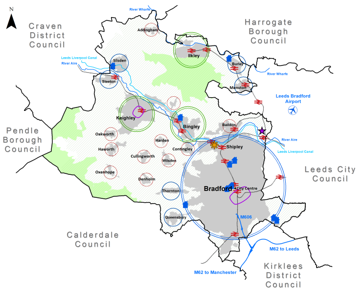
[1] A set of comprehensive site assessment criteria are included within the published Bradford District Sites Assessment Methodology and Report (2021).
[2] Headlines summarised from The Bradford District Economic Recovery Plan.
[3] Made in Bradford – 'Pioneering, Confident & Connected: An Economic Strategy for the Bradford District 2018-2030'.
[7] Public Health England (2017) op cit.