
Draft Bradford District Local Plan - Preferred Options (Regulation 18) February 2021
Queensbury
Introduction
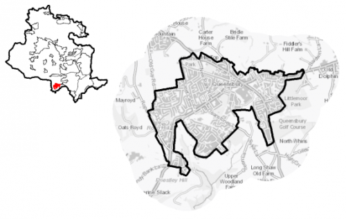
5.25.1 Queensbury is a large village located in the south-west of the District and is close to the boundary with neighbouring Calderdale. Queensbury lies on the A647, one of the main routes between Bradford and Halifax, and also on the A644, the main route between Keighley and Brighouse. Queensbury is noted for being one of the highest villages in England, at 1,100 feet above sea level. It is one of nine settlements located in the South Pennine Towns and Villages sub-area. Queensbury falls within the Bradford South Parliamentary Constituency and within the Queensbury Ward.
Figure 1: Location Plan
5.25.2 It has a population of 9,197 and a high proportion of this (63.5%) falls within the working age category (16-64). The age profile of the settlement is comparable to the West Yorkshire and England averages.
5.25.3 The ethnic composition of Queensbury is primarily made up of people who identify themselves as White British – accounting for 94.5%. This is notably higher than the West Yorkshire average (78.4%), but is similar to other more rural locations in the District.
Planning for Prosperity
5.25.4 The Local Plan settlement hierarchy identifies Queensbury as one of Bradford district's six Local Growth Centres. This means that it will make a significant contribution to meeting the District's needs for housing and employment, and provide supporting community facilities.
5.25.5 Queensbury scores slightly lower than the West Yorkshire average across all deprivation measures if measured by number of people in the are living within the 20% most deprived areas of England as ranked by the Indices of Multiple Deprivation. Further information is detailed in Figure 2.
Figure 2: Queensbury Indices of Multiple Deprivation
|
Number of people in Queensbury living in the most deprived 20% of areas of England by Indices of Deprivation (ID) 2019 domain |
||||||
|
Index of Multiple Deprivation |
Income domain |
Employment domain |
Education domain |
|||
|
2,498 |
0 |
0 |
1,416 |
|||
|
27.2% (West Yorkshire average = 36.2%) |
(West Yorkshire average = 31.9%) |
(West Yorkshire average = 32.4%) |
15.4% (West Yorkshire average = 35.3%) |
|||
|
Health domain |
Barriers to Housing and Services domain |
Living Environment domain |
Crime domain |
|||
|
2,498 |
0 |
4,930 |
4,930 |
|||
|
27.2% (West Yorkshire average = 33.8%) |
(West Yorkshire average = 1.8%) |
53.6% (West Yorkshire average = 39.8%) |
53.6% (West Yorkshire average = 48.2%) |
|||
|
Source: Ministry of Housing, Communities and Local Government (Indices of Deprivation 2019) |
||||||
Economy and Employment
5.25.6 Economic activity rates are relatively positive for Queensbury with 75% of the resident population economically active compared to the West Yorkshire average (68.5%) and of those a slightly higher number being in full-time employment compared to the sub-regional average. Average household income at £42,600 is also above the West Yorkshire average (£38,499). The main employment sectors that the residents of Queensbury work in include retail, health and social work, and manufacturing.
5.25.7 Queensbury has a number of small independent businesses, many of which consist of local shops and services (e.g. car repair, estate agents). The Black Dyke Mill complex houses a number of industrial, retail and commercial businesses, but there are some vacant units within the complex. Other local employment opportunities are in the form of services, for example local schools, health centres, veterinary practice. There are also opportunities at Sidhil Business Park and Holmfield Industrial Estate in Illingworth in neighbouring Calderdale, and other key employment is found in nearby Bradford and Halifax.
5.25.8 Business Register and Employment Survey (BRES) data indicates that the three largest industry groups by workforce jobs (all people in employment) are: health (20.1%), education (17.9%) and manufacturing (17.5%).
5.25.9 The local plan does not seek to specifically allocate employment land within this Local Growth Centre, but the plan is supportive of appropriately sited and scaled economic growth and diversification within the Pennine Towns and Villages.
Retail
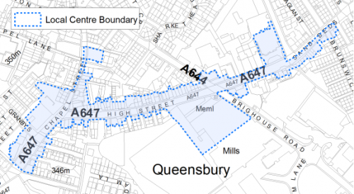
5.25.10 There is a good range of shops within Queensbury, the centre contains a total of 74 retail units which incorporate both convenience and comparison uses. There is a Tesco superstore on Brighouse Road and Co-op Food Store on High Street, providing the main food retail outlets. Other local independent shops offer a good variety of retail and services, including a post office, newsagents, hairdressers/barbers, hardware store, estate agents, takeaways, garage and car repairs, cafes and public houses.
5.25.11 The 2019 Retail and Leisure Study concluded that Queensbury is generally an attractive centre, which is in a good state of maintenance, however, there are a number of vacant units and some which are in a poor state of repair. Consideration should be given to bringing these units back into use to ensure the vitality of the centre. Opportunities to provide better connections and use of the Black Dyke Mills complex should also be explored. The extent of the local centre is shown in figure 3 below.
Figure 3: Queensbury Local Centre
Transport and Access
5.25.12 Transport connections for Queensbury are focussed around the two road corridors of the A647 (Halifax Road) and the A644 (Brighouse and Denholme Road), which connects Queensbury to Bradford, Halifax, Keighley and Brighouse.
5.25.13 Queensbury is served by two key bus services: the 526 (operated Yorkshire Tiger) and 576 (operated by First Buses). The 526 provides an hourly service connecting Queensbury to Halifax, and the 576 provides (on average) a 15-minute service connecting it to Bradford and Halifax. The nearest railway station is located around 6km to the south at Halifax. Services from Halifax provide connections into Bradford, Leeds, Manchester and further afield with direct services to London.
5.25.14 There are numerous footpaths and bridleways leading out from Queensbury into the countryside and connecting into the wider public rights of way network, including the Great Northern Railway Trail which links Queensbury to Thornton. The Local Plan will protect the Queensbury Tunnel which runs under the settlement as part of a wider connection with the Great Northern Trail which provides a longer walking and cycling route connecting settlements including Cullingworth and Thornton. Table 1 and the Policies map shows the protected route.
Table 1: Queensbury Transport Route
|
Policies Map Ref. |
Project Name |
|
TR1.A.5 |
Queensbury Tunnel (Walking and cycling route) |
Planning for Homes
5.25.15 Queensbury has 3,750 dwellings within the settlement area. A large proportion of these properties are owner occupied (76.9%), which is slightly higher than the West Yorkshire (63.4%) and England (64.1%) averages. Around 16% of properties are in private rented tenure and 7% in social rented tenure. Similar to the other South Pennine settlements in the District, the amount of affordable housing provided in Queensbury is notably low, particularly when compared to the West Yorkshire (18% social rented) and England (18% social rented) averages.
5.25.16 There are a mix of house types in Queensbury, with a concentration of older terraced properties and cottages around the centre of the settlement off High Street/Sand Beds/Scarlett Heights. As the settlement has expanded a number of detached and semi-detached properties have been provided. A number of new developments in recent years have further diversified the range and types of houses on offer in Queensbury. The breakdown of house types is: detached (21.4%), semi-detached (33.4%) and terraced (40.2%) with a small proportion of flats (c.4%). Compared to the West Yorkshire average, Queensbury sees a higher percentage of terraced and detached properties.
5.25.17 The average house price (all types) in Queensbury is £144,504 which is notably lower than the West Yorkshire average of £183,194. The average house price is below sub-regional figure for all house types as detailed below in Figure 4.
Figure 4: Queensbury – House Prices
|
Average house price (all types of housing) (Land registry Sept-19 to August-20) |
Average house price (detached) (Land registry Sept-19 to August-20) |
Average house price (flats) (Land registry Sept-19 to August-20) |
||
|
£144,504 |
£242,065 |
£71,000 |
||
|
West Yorkshire average = £183,194 |
West Yorkshire average = £324,872 |
West Yorkshire average = £128,299 |
||
|
Average house price (semi-detached) (Land registry Sept-19 to August-20) |
Average house price (terraced) (Land registry Sept-19 to August-20) |
Households in Council Tax Band A (Valuation Office Agency (VOA) 2020) |
||
|
£161,027 |
£91,141 |
1,177 |
||
|
West Yorkshire average = £178,439 |
West Yorkshire average = £132,430 |
28.3% (West Yorkshire average = 43.1%) |
||
|
Households in Council Tax Band B (VOA 2020) |
Households in Council Tax Band C (VOA 2020) |
Households in Council Tax Band F-H (VOA 2020) |
||
|
829 |
861 |
139 |
||
|
20.0% (West Yorkshire average = 20.2%) |
20.7% (West Yorkshire average = 17.6%) |
3.3% (West Yorkshire average = 4.3%) |
5.25.18 The delivery of new housing is a key part of the development strategy for Queensbury. This will ensure that the housing needs of local people can be met, both in terms of market and affordable housing. New housing will also allow for the modest growth of the settlement, to attract new residents and to help sustain the provision of services and facilities.
5.25.19 Policy SP8 in the local plan sets out a minimum requirement of 450 dwellings to be delivered in Queensbury during the plan period. These will be delivered through a mix of committed sites (those under construction or have planning permission but have not yet commenced) and allocations. Table 2 below sets out the housing position for Queensbury, which also includes the application of non-implementation or discount rates for planning permissions and allocations.
Table 2: Queensbury - Summary of Housing Requirement and Supply
|
Housing Target |
450 units |
|
Carried Forward Commitments |
19 |
|
Commitment Discounted by 10% |
17 |
|
Remaining Allocation Requirement |
433 |
|
Identified Allocations |
481 |
|
Allocations Discounted by 10% |
433 |
|
Total Supply Contribution from Allocations |
433 |
5.25.20 Once the commitments are discounted and removed from the supply, this leaves a residual allocation requirement of 433 units. The evaluated total site supply of housing units from the preferred allocation sites equates to 481 units which is in turn discounted by 10% for non-implementation or under delivery leaving a final allocation contribution of 433 units.
5.25.21 A mix of different sized sites have been identified as the preferred housing allocations for Queensbury to meet the housing requirement. These consist of one brownfield and 8 greenfield sites, 7 of which are Green Belt sites. This range of sites will help to ensure the delivery of homes continues to meet the needs of the population of Queensbury and provide development opportunities for small and medium developers as well as the larger volume house builders. In delivering the target for new homes in Queensbury it has been necessary to make some changes to the adopted green belt. Policy SP5 sets out the Council's approach and justification for green belt releases to accommodate new development and lists the sites proposed for allocation which current lie within or partly within the green belt. Further information on these proposed sites is set out in Table A and identified on the Policies Map and the Site Pro Formas below, together with the local strategies map for each plan area. Development of these site allocations should be in accordance with specified development guidelines and approximate site provision figures and all other relevant policies of this Local Plan. The Council will be supportive of additional proposals for new homes on additional small sites, particularly those that provide a redevelopment opportunity to bring forward land which has been previously used. Support will also be provided to developers who wish to redevelop larger sites and/or buildings for new homes not currently identified, subject to all relevant policies in the Local Plan.
Planning for Places and Communities
Green Belt, Natural Landscape and Historic Character
5.25.22 Queensbury is surrounded by Green Belt which is tightly drawn around the settlement's built form, which currently restricts the expansion the settlement. Three Landscape Character types are identified in the countryside surrounding Queensbury. To the west, north and east is Mixed Upland Pasture. This landscape has moderate strength of character, medium historic continuity, and is prominent and open – as such it is sensitive to change, although there is some potential on the north western side of the settlement. To the south there is an area of Wooded Valley which encompasses Shibden Brook. This landscape has a strong character, high historic continuity and mixed visible/hidden characteristics with a strong sense of enclosure. It is moderately sensitive to change and any development should retain, conserve and enhance the tree cover. There is also an area of Upland Pasture to the south, which again has a reasonably strong character, high historic continuity and is visible and open. This landscape is sensitive to change with development sited too close to the steep valley sides being discouraged to ensure a strong edge to Queensbury is maintained.
5.25.23 Queensbury has a rich heritage with the initial growth of the settlement being attributed to the growth of the wool trade. The historic core of the settlement is focussed around the Grade II Listed Black Dyke Mills, with this part of the settlement being designated as a Conservation Area. There are a total of 20 Grade II listed buildings and structures within the settlement area.
Green Infrastructure, Ecology, Open Space and Flood Risk
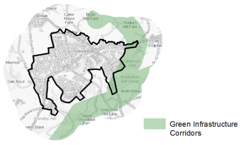
5.25.24 Areas to the east, south and partly to the north of the settlement form part of the District's Green Infrastructure (GI) network and should be protected and enhanced. These areas are multi-functional in nature and help to deliver benefits for biodiversity, reduce flood risk, provide public rights of way, and connect areas of open space together.
Figure 5: Green Infrastructure Corridors
5.25.25 There are no Local Wildlife Sites of Local Nature Reserves within the settlement limits of Queensbury. However, to the south there is the Shibden Head Local Wildlife Site. Also to the south and east there are areas of important wildlife habitat with areas of semi-improved neutral grassland, broad-leaved woodland, and ancient and semi-natural woodland forming part of the habitat network – connecting spaces together and allowing for the movement of species. There are areas of priority habitat around Fosters/Littlemoor Park both within and out with the settlement limits.
5.25.26 Queensbury falls within the 7km zone of the internationally designated wildlife habitat of the South Pennine Moors SPA/SAC.
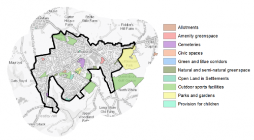
5.25.27 There are 28 open space sites of various types within the settlement which cover a total area of 50.24ha. This represents a good overall level of provision, however, there are some imbalances in terms of the types of spaces provided. Key open space sites in Queensbury which provide for recreation opportunities include: Foster/Littlemoor Park, Russell Hall park, Albert Road playing fields, Foxhill park football pitch, Long Land playing fields and Queensbury golf course. Figure 6 shows the location and types of open spaces in Queensbury.
Figure 6: Queensbury – Open Space Overview
5.25.28 Queensbury is located in an elevated position with limited watercourses running through the settlement. There are no areas within the settlement which are at risk of fluvial flooding. However, there are notable areas across the settlement which are at risk of surface water flooding. In particular areas around Shibden Brook to the west of the settlement and also to the south around Deanstones Lane and Cherton Drive/Harrowins Farm.
Community Infrastructure – Education, Health and Utilities
5.25.29 Queensbury has a range of community facilities available to meet the day to day needs of local people. These consist of local shops, takeaways, cafes, a library, places of worship, a gym, parks, play areas, playing fields, public houses, and an entertainment venue. For a wider range of shops and facilities, sport and leisure centres, residents would need to travel further in to Bradford or Halifax to access such services.
5.25.30 Queensbury has three Primary schools: Shibden Head Primary Academy, Russell Hall Primary School and Foxhill Primary School and one Secondary school: Queensbury Academy.
5.25.31 There are two medical practices in Queensbury located on Russel Road (Queensbury Health Centre) and Osbourne Drive (The Willows Medical Centre) offering primary care services to local residents. Secondary (acute) healthcare is provided at Bradford Royal Infirmary which is around 5km north east of the village. There are three pharmacies within the village providing over the counter medicines and prescription services. There is also two dental practices and an opticians within the village. Figure 7 shows the location of local services in the town.
Figure 7: Queensbury – Schools and GP Practices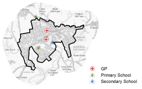
5.25.32 When planning for the long-term development of Queensbury, it is vital that new development is supported by the appropriate infrastructure. The capacity, quality and accessibility of services and facilities are all key components in ensuring people can enjoy living, working and visiting the area. The Council will continue work with key infrastructure providers and others including the Local Education Authority, Clinical Commissioning Group and utilities providers to determine the impacts of future growth and development on local infrastructure capacity and provision. Further infrastructure details will be published through the Local Infrastructure Plan and as part of the Regulation 19 stage of the local plan.
|
Local Area Strategy and Plan - Queensbury The key elements of the local area strategy for Queensbury include:
|

(19) Consultation Question 136
Queensbury Local Area Strategy
The Local Plan sets out a local area strategy for Queensbury.
Q. Please provide any comments you may have on the area strategy?
If you have an alternative to the approach undertaken, please provide further details and evidence in support.
Preferred Site Allocations and Site Pro Formas
5.25.33 The preferred housing site allocations are detailed below in Table A. This table is subsequently followed by site pro formas providing a summary of key site information and characteristics.
Table A: Housing - Preferred Allocations
|
Site Ref |
Site Name |
Dwellings |
|
QB1/H |
Albert Road / Denholme Road |
22 |
|
QB2/H |
Albert Road |
31 |
|
QB3/H |
Black Dyke Mills |
15 |
|
QB4/H |
Brighouse Road |
40 |
|
QB5/H |
Jackson Hill Lane / Brighouse Road |
41 |
|
QB6/H |
Station Road West / Sharket Head Close |
30 |
|
QB7/H |
Old Guy Road / Fleet Lane |
260 |
|
QB8/H |
Long Lane (2) |
22 |
|
QB9/H |
Long Lane (1) |
20 |
|
Total |
481 |
(130) Consultation Question 137
Queensbury Site Allocation and Site Pro Forma
The Local Plan sets out a preferred site allocation for Queensbury. If you wish to make representations on the site proposed, please provide feedback under this question.
If you wish to propose an additional or alternative site(s) to the preferred allocation listed, please also provide a plan with a red line and any further details in support.
(5) QB1/H - Albert Road, Brighouse and Denholme Road
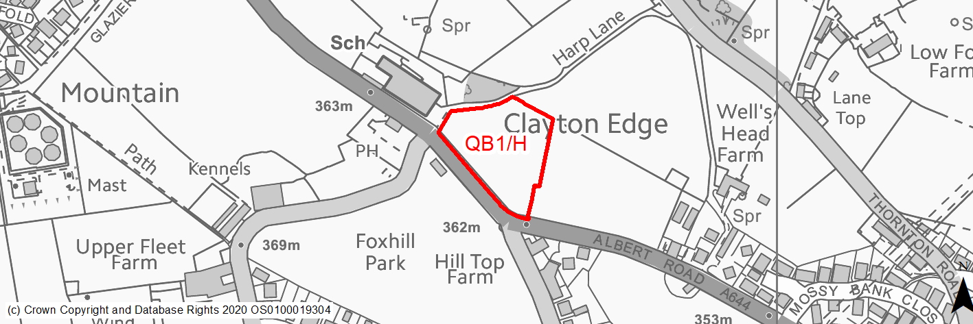
Site location
Local Growth Centre - Queensbury
Ward
Queensbury Ward
Site description
This is a reasonably flat Greenfield site which slopes downhill on the northern edge. The site is pasture/meadow land. There is a school to the west and a vacant, previously developed site to the east. The site adjoins the settlement of Queensbury along its eastern and southern boundary. The site boundaries are made up of roads, tracks and field boundaries in the form of hedgerows and dry stone walls.
Proposed Allocation
Housing
SHLAA referencce
QB/001
Indicative no. dwellings
22
Site area (Gross) (ha)
0.7
Ownership
Private
Delivery timescales
Developable (6-10 years)
Type (PDL/Greenfield)
Greenfield
Green Belt
Yes
Flood Zone
Flood Zone 1
Potential site access
There is an existing field gate access into the site. However, a new access point would be required - possibly through QB2/H as part of a comprehensive development.
Public Transport Accessibility
The site is within 400m of a bus stop but only has an hourly service.
Sustainability Appraisal
The site could deliver major positive effects for residents on the health and education SA Objectives as a result of being within the target distances for all necessary health facilities and centres for primary and secondary education.
Minor positive effects were predicted for nearly all other socio-economic themed SA Objectives due to the benefits of new residential development for the local economy as well as the location of the site in relation to transport links, local services and amenities, and employment areas.
There have been no significant adverse effects predicted. The site is 100% greenfield and Green Belt, meaning development could reduce biodiversity value at the site and would be likely to have a negative impact on the local landscape and townscape; therefore minor adverse effects were predicted for a range of natural environment themed SA Objectives. The southern perimeter of the site adjoins a Grade II Listed milestone, the setting of which could be adversely affected by development here.
Habitats Regulations Assessment
This site falls within 7km of the South Pennine Moors SPA/SAC. A HRA must be undertaken to ensure there are no significant effects on these protected sites. Developments within these zones must comply with Policy SP11; a SPD is being produced to provide further guidance.
Green Belt
Based on planning judgement the site has a moderate potential impact on the Green Belt.
• The site is located in a low Green Belt parcel.
• The site makes a moderate contribution to the purposes of including land in the Green Belt.
• The site has a moderate potential for sprawl and would have a major impact on openness.
• There is limited opportunity to create a stronger Green Belt boundary than the existing boundary.
Constraints and Opportunities
• The site is currently designated as Green Belt, and the site specific Green Belt assessment indicates that it has a moderate potential impact.
• A new access into the site will be required.
• The site would have a moderate impact on the landscape.
• The site is located within the 7km buffer of the SPA/SAC.
Development considerations
• Provision of compensatory improvements to the surrounding Green Belt should be made and may include enhancement of the existing rights of way adjacent to the site.
• Access into the site requires careful consideration and may benefit from a joint scheme with site QB2/H.
• Sensitive design, including layout, height of buildings and use of soft landscaping to mitigate any impact on the Mixed Upland Pasture landscape.
Conclusion/Summary
This is a level site which is sustainably located adjacent to the settlement boundary and near to local services and facilities, including a primary school and open space. It would deliver an estimated 22 dwellings and could be brought forward as part of a larger scheme incorporating site QB2/H.
(3) QB2/H - Albert Road
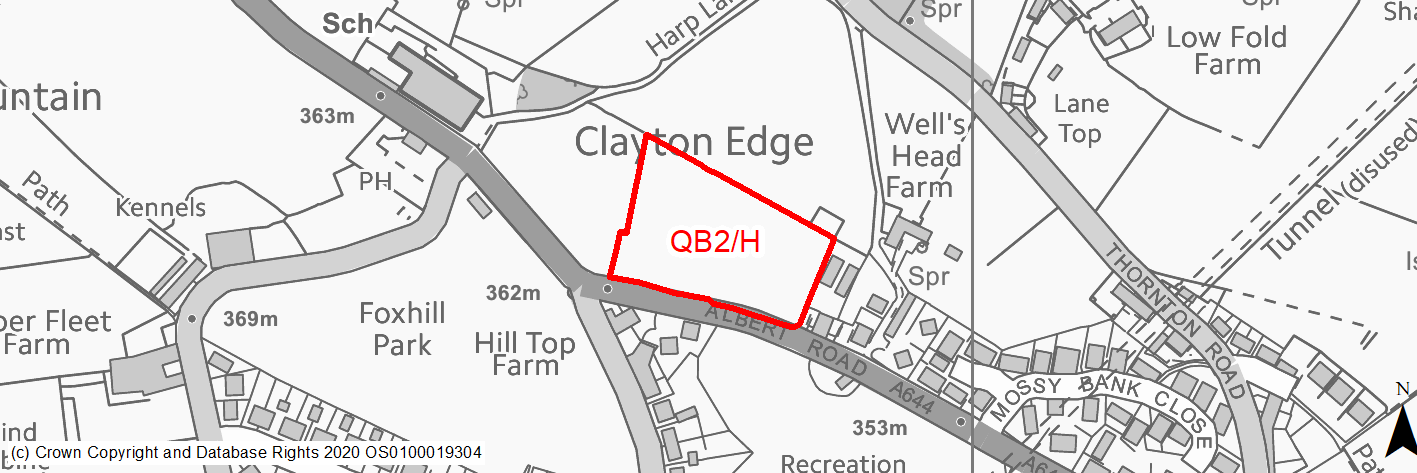
Site location
Local Growth Centre - Queensbury
Ward
Queensbury Ward
Site description
This is a former scrapyard which has been cleared. It is mainly level but with some notable undulations and significant mounded earth works along the western boundary. The site is slowly becoming overgrown with vegetation but is still derelict in form. The site boundaries are made up of Albert Road to the south, existing development to the east and a drystone wall and hedgerow to the north and west.
Proposed Allocation
Housing
SHLAA referencce
QB/002
Indicative no. dwellings
31
Site area (Gross) (ha)
0.968042580001245
Ownership
Private
Delivery timescales
Developable (6-10 years)
Type (PDL/Greenfield)
PDL
Green Belt
No
Flood Zone
Flood Zone 1
Potential site access
There is an existing access point off Albert Road.
Public Transport Accessibility
The site is within 400m of a bus stop but only has a limited service.
Sustainability Appraisal
No significant adverse effects predicted for the site. Minor adverse effects have been predicted for most natural environment themed SA Objectives. Whilst the site has been previously developed, it has now been partly re-vegetated. The site would provide residents with good access to key services and amenities, including jobs, shops, buses, and cultural spaces, with particularly good access to health and education facilities.
Habitats Regulations Assessment
This site falls within 7km of the South Pennine Moors SPA/SAC. A HRA must be undertaken to ensure there are no significant effects on these protected sites. Developments within these zones must comply with Policy SP11; a SPD is being produced to provide further guidance.
Green Belt
N/A – Site not within the Green Belt.
Constraints and Opportunities
• The site is previously developed and derelict and offers the opportunity to improve this edge of settlement location.
• Records indicate previous landfill activities and potential contamination from previous uses.
• The site is located within the 7km buffer of the SPA/SAC.
Development considerations
• Design and layout will need to respond to the elevated position of the site and the wider landscape.
• Site investigation will be required to confirm and mitigate any contamination issues.
• Direct vehicular and pedestrian access off Albert Road.
Conclusion/Summary
This is a level, previously developed site, sustainably located within the setttlement boundary and near to a number of local services including a primary school and open space. It would deliver an estimated 31 dwellings and could be brought forward as part of a larger scheme incorporating site QB1/H.
(6) QB3/H - Black Dyke Mills, Brighouse Road
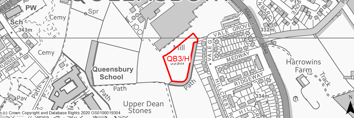
Site location
Local Growth Centre - Queensbury
Ward
Queensbury Ward
Site description
This is an area of unused land with an undulating topography and the presence of earth works as a result of the adjacent development. The site is in close proximity to Black Dyke Mills and is mainly covered in vegetation. The site is bounded by a road, the rear gardens of adjacent properties and a strong tree line.
Proposed Allocation
Housing
SHLAA referencce
QB/004
Indicative no. dwellings
15
Site area (Gross) (ha)
0.57
Ownership
Private
Delivery timescales
Developable (11-15 years)
Type (PDL/Greenfield)
Greenfield
Green Belt
No
Flood Zone
Flood Zone 1
Potential site access
There is an existing access off Old Mill Dam Lane.
Public Transport Accessibility
The site is within 400m of a bus stop but only has a limited service.
Sustainability Appraisal
The site could deliver major positive effects for residents on the health and education SA Objectives as a result of being within the target distances for all necessary health facilities and centres for primary and secondary education.
Minor positive effects were predicted for nearly all other socio-economic themed SA Objectives due to the benefits of new residential development for the local economy as well as the location of the site in relation to transport links, local services and amenities, and employment areas.
No major adverse effects have been predicted for the site, but minor adverse effects were predicted for a range of natural environment themed SA Objectives, primarily as a result of the impacts of new development on a greenfield site containing TPO woodland. Queensbury Conservation Area is 35m north-west of the site and is also in close proximity to the Grade II Listed Building of Black Dyke Mills, development at the site could have an adverse effect on the setting of this sensitive historic area. The site contains a very limited extent of land at a low, medium and high risk of surface water flooding in the north, which is expected to be avoided through a careful layout of the development.
Habitats Regulations Assessment
This site falls within 7km of the South Pennine Moors SPA/SAC. A HRA must be undertaken to ensure there are no significant effects on these protected sites. Developments within these zones must comply with Policy SP11; a SPD is being produced to provide further guidance.
Green Belt
N/A – Site not within the Green Belt.
Constraints and Opportunities
• Potential impact on the Grade II Listed Black Dyke Mills.
• The site has differing levels and may require some earthworks to create appropriate development areas.
• There are TPO trees located along the eastern boundary.
• The site is located within the 7km buffer of the SPA/SAC.
Development considerations
• A Heritage Impact Assessment has been carried out to assess the impact on the adjacent Grade II Listed Black Dyke Mills. Following this assessment the site boundaries were redrawn to include only the southern portion of land. A sensitively designed scheme will be required to mitigate any impact.
• Earthworks and remediation of the site may be required to establish appropriate development areas.
• A sensitive layout will be required to ensure TPO trees are protected.
• Direct vehicular and pedestrian access off Old Mill Dam Lane.
Conclusion/Summary
This site is sustainably located within the settlement boundary near local services and facilities, including a supermarket, other local shops and a secondary school. It would deliver an estimated 15 dwellings and would complete the redevelopment of this land complementing the recent development to the West of Black Dyke Mills.
(50) QB4/H - Brighouse Road
Site location
Local Growth Centre - Queensbury
Ward
Queensbury Ward
Site description
This is a realtively flat site with some undaltions and a slight slope downwards to the east. The site has recently been used as a storage area for the adjacent development site. There is residential development to the north and west, a golf course to the south and woodland to the east. The southern site boundary is formed by a dry stone wall. The eastern and western boundaries are made up of a tree line/hedegrow vegetation. The northern boundary is made up of the gardens and hard infrastructure of the adjacent housing development.
Proposed Allocation
Housing
SHLAA referencce
QB/007
Indicative no. dwellings
40
Site area (Gross) (ha)
1.52
Ownership
Private
Delivery timescales
Developable (6-10 years)
Type (PDL/Greenfield)
Greenfield
Green Belt
Yes
Flood Zone
Flood Zone 1
Potential site access
An access point from the new development off Harrowins Farm Drive has been created.
Public Transport Accessibility
The site is within 400m of a bus stop but only has a limited service.
Sustainability Appraisal
There are unlikely to be any significant effects, either positive or negative, on any SA Objective arising as a result of development at this site.
Minor positive effects were predicted for most socio-economic themed SA Objectives due to the benefits of new residential development for the local economy as well as the location of the site in relation to transport links, local services and amenities, health and education facilities and employment areas.
The site is partial greenfield, and on Green Belt land. The southern portion of the site is TPO woodland, and so avoiding adverse effects on the local character, as well as the local ecological network, would be difficult. As such, minor adverse effects were predicted for a range of natural environment themed SA Objectives.
Habitats Regulations Assessment
This site falls within 7km of the South Pennine Moors SPA/SAC. A HRA must be undertaken to ensure there are no significant effects on these protected sites. Developments within these zones must comply with Policy SP11; a SPD is being produced to provide further guidance.
Green Belt
Based on planning judgement the site has a moderate potential impact on the Green Belt.
• The site is located in a moderate Green Belt parcel.
• The site makes a low contribution to the purposes of including land in the Green Belt.
• The site has a moderate potential for sprawl and would have a moderate impact on openness.
• There is some opportunity to create a stronger Green Belt boundary than the existing boundary.
Constraints and Opportunities
• The site is currently designated as Green Belt, and the site specific Green Belt assessment indicates that it has a moderate potential impact.
• The site is in a Local Wildlife Network and Green Infrastructure Corridor.
• TPO trees are located along the southern and eastern boundaries.
• The site is located within the 7km buffer of the SPA/SAC.
Development considerations
• Provision of compensatory improvements to the surrounding Green Belt will be required and may include enhancement of the existing environmental assets (Local Wildlife Network, Green Infrastructure Corridor) adjacent to the site.
• An ecological survey will be required to establish the ecological status of the site prior to development.
• Sensitive design and layout will be required to ensure the TPO trees are protected appropriately.
• Direct vehicular and pedestrian access can be provided off Harrowins Farm Drive.
Conclusion/Summary
This is a level site which is sustainably located adjacent to the settlement boundary and within reasonable proximity to local services including shops and open space. It would deliver an estimated 40 dwellings and would complement the recently completed development at Harrowins Farm Drive.
(6) QB5/H - Jackson Hill Lane, Brighouse Road
Site locationTH3/H - Thornton Road
Local Growth Centre - Queensbury
Ward
Queensbury Ward
Site description
This is a reasonably level site. The site is predominately grassed with some vacant buildings and areas of hard standing. The site adjoins the settlement of Queensbury on the site’s northern boundary. The site’s eastern and southern boundaries are formed by made roads and the western boundary is formed by a track/driveway and existing development.
Proposed Allocation
Housing
SHLAA referencce
QB/010
Indicative no. dwellings
41
Site area (Gross) (ha)
1.3
Ownership
Private
Delivery timescales
Developable (6-10 years)
Type (PDL/Greenfield)
Greenfield
Green Belt
Yes
Flood Zone
Flood Zone 1
Potential site access
Existing field gate access points are available off Jackson Hill Lane and Brighouse Road. Both are single width accesses and would require significant improvements / new junctions.
Public Transport Accessibility
The site is adjacent to a bus stop but only has a limited service.
Sustainability Appraisal
There are unlikely to be any significant effects, either positive or negative, on any SA Objective arising as a result of development at this site.
Minor positive effects were predicted for nearly all socio-economic themed SA Objectives due to the benefits of new residential development for the local economy as well as the location of the site in relation to transport links, health and education facilities and employment areas.
As a greenfield and Green Belt site, the loss of which could reduce biodiversity value and adversely affect the local townscape character, minor adverse effects have been predicted for the site for most natural environment themed SA Objectives.
Habitats Regulations Assessment
This site falls within 7km of the South Pennine Moors SPA/SAC. A HRA must be undertaken to ensure there are no significant effects on these protected sites. Developments within these zones must comply with Policy SP11; a SPD is being produced to provide further guidance.
Green Belt
Based on planning judgement the site has a low potential impact on the Green Belt.
• The site is in a low Green Belt parcel.
• The site makes a low contribution to the purposes of including land in the Green Belt.
• The site has a moderate potential for sprawl and would have a moderate impact on the openness of the Green Belt.
• There is an opportunity to create a stronger Green Belt boundary than the existing boundary.
Constraints and Opportunities
• The site is currently designated as Green Belt, and the site specific Green Belt assessment indicates that it has a low potential impact.
• The development of this site presents an opportunity to improve the gateway landscape character on entering Queensbury.
• The site is located within the 7km buffer of the SPA/SAC.
Development considerations
• Provision of compensatory improvements to the surrounding Green Belt will be required and may include enhancement of the existing rights of way network and Local Wildlife Network adjacent to the site.
• A sensitive design and layout will be required to ensure the landscape of this gateway location is enhanced.
• Vehicular and pedestrian access is available off Brighouse Road but will require the formation of a new junction.
Conclusion/Summary
This is a level site which is located adjacent to the settlement boundary and provides a suitable extension to the urban area, being contained by Brighouse Road and Jackson Hill Lane. It would deliver an estimated 41 dwellings and improve the townscape in this gateway location.
(6) QB6/H - Station Road west/Sharket Head Close
Site location
Local Growth Centre - Queensbury
Ward
Queensbury Ward
Site description
This site has a varied topography but generally slopes gentley down to the north with a steeper drop on the northern boundary. The site consists of a grassed field and has boundaries that are made up of a mix of drystone walls, rear gardens and retaining structures, a strong tree line, a road and a notable change in topography.
Proposed Allocation
Housing
SHLAA referencce
QB/011A
Indicative no. dwellings
30
Site area (Gross) (ha)
1.31
Ownership
Private
Delivery timescales
Developable (6-10 years)
Type (PDL/Greenfield)
Greenfield
Green Belt
Yes
Flood Zone
Flood Zone 1
Potential site access
There are potential access points into the site off either Sharket Head Close or Station Road.
Public Transport Accessibility
The site is within 400m of a bus stop with a 10 minute service.
Sustainability Appraisal
The site could deliver major positive effects for residents on the health and education SA Objectives as a result of being within the target distances for all necessary health facilities and centres for primary and secondary education.
Minor positive effects were predicted for nearly all other socio-economic themed SA Objectives due to the benefits of new residential development for the local economy as well as the location of the site in relation to transport links, local services and amenities, and employment areas.
No major adverse effects have been predicted for the site. The site is a vacant plot but contains an area of TPO woodland, and avoiding adverse effects from the development on this and the local ecological network would be difficult. However, new development at the site could be an opportunity to enhance the local townscape character, depending on how the development is implemented. There is a small waterbody 80m north of the site, the water quality of which could be impacted by the development.
Habitats Regulations Assessment
This site falls within 7km of the South Pennine Moors SPA/SAC. A HRA must be undertaken to ensure there are no significant effects on these protected sites. Developments within these zones must comply with Policy SP11; a SPD is being produced to provide further guidance.
Green Belt
Based on planning judgement the site has a moderate potential impact on the Green Belt.
• The site is located in a moderate Green Belt parcel.
• The site makes a moderate contribution to the purposes of including land in the Green Belt.
• The site has a moderate potential for sprawl and would have a major impact on the openness of the Green Belt.
• There is opportunity to create a marginally stronger Green Belt boundary than the existing one.
Constraints and Opportunities
• The site is currently designated as Green Belt, and the site specific Green Belt assessment indicates that it has a moderate potential impact.
• Potential impact on the Queensbury Conservation Area.
• Potential minor impact on the wider landscape.
• The site is within a Green Infrastructure Corridor.
• The site is located within the 7km buffer of the SPA/SAC.
Development considerations
• Provision of compensatory improvements to the surrounding Green Belt will be required and may include enhancement of the existing rights of way network adjacent to the site.
• A sensitive site design will be required to mitigate any impact on the conservation area, Green Infrastructure corridor and the wider landscape.
• Direct vehicular and pedestrian access is available off Sharket Head Close. A secondary access is available off Station Road.
Conclusion/Summary
This site is located adjacent to the settlement boundary and provides a suitable extension to the urban area complementing the existing development at Sharket Head Close. It would deliver an estimated 30 dwellings and is located in close proximity to local services and facilities.
(10) QB7/H - Fleet Lane
Site location
Local Growth Centre - Queensbury
Ward
Queensbury Ward
Site description
This site consists of open agricultural fields. It is of reasonably level topography and is bounded by dry stone walls on the north and western boundaries, a road to the east and the rear gardens of existing development to the south.
Proposed Allocation
Housing
SHLAA referencce
QB/014A
Indicative no. dwellings
260
Site area (Gross) (ha)
5.1
Ownership
Private
Delivery timescales
Developable (6-15 years)
Type (PDL/Greenfield)
Greenfield
Green Belt
Yes
Flood Zone
Flood Zone 1
Potential site access
There are potential access points into the site off Fleet Lane.
Public Transport Accessibility
The site is within 400m of a bus stop but with only an hourly service.
Sustainability Appraisal
The site could deliver a major positive effect for residents on the education SA Objective as a result of being within the target distance for both primary and secondary education facilities.
Minor positive effects were predicted for most other socio-economic themed SA Objectives due to the benefits of new residential development for the local economy, as well as the location of the site in relation to transport links, health facilities and employment areas, although residents may need to travel up to 1.3km to access basic services and amenities.
No major adverse effects have been predicted for the site, but minor adverse effects were predicted for a range of natural environment themed SA Objectives, primarily as a result of the impacts of new development on a large 100% greenfield and Green Belt site.
Habitats Regulations Assessment
This site falls within 7km of the South Pennine Moors SPA/SAC. A HRA must be undertaken to ensure there are no significant effects on these protected sites. Developments within these zones must comply with Policy SP11; a SPD is being produced to provide further guidance.
Green Belt
See individual Green Belt site assessment in the accompanying report.
Constraints and Opportunities
• The site is currently designated as Green Belt.
• Development would have a moderate impact on the landscape.
• The scale of the development would provide an opportunity to provide some additional open space in this part of Queensbury.
• The site is located within the 7km buffer of the SPA/SAC.
Development considerations
• Provision of compensatory improvements to the surrounding Green Belt will be required and may include enhancement of the existing rights of way network adjacent to the site.
• A sensitive site design will be required to mitigate any impact on the landscape, ensuring the layout and height of properties is appropriate to the character of this part of Queensbury.
• Vehicular and pedestrian access is available off Fleet Lane.
Conclusion/Summary
This is a level site which is sustainably located adjacent to the settlement boundary and near to local services and facilities, including a primary school and open space. It would deliver an estimated 260 dwellings and additional open space provision.
(11) QB8/H - Long Lane
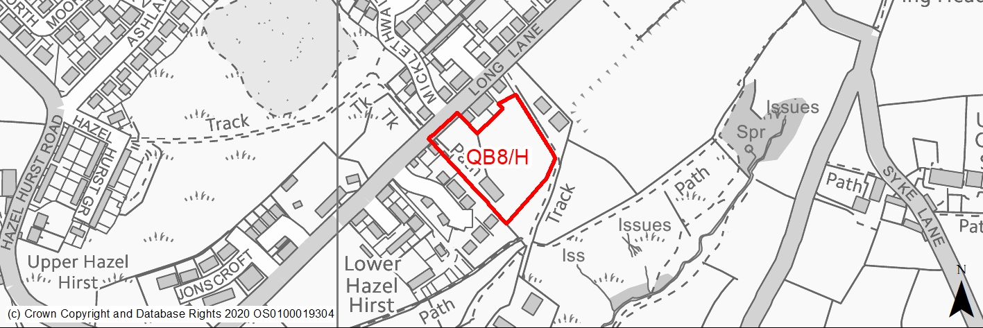
Site location
Local Growth Centre - Queensbury
Ward
Queensbury Ward
Site description
This is a relatively flat agricultural field with a slight slope to the south of the site. The site boundaries are formed of a made road (Long Lane), the rear gardens of properties on Long Lane and Henacrewood Court (which include dry stone walls, wooden fence panels and vegetation), a well established track and a signficiant change in topography on the southern edge.
Proposed Allocation
Housing
SHLAA referencce
QB/036
Indicative no. dwellings
22
Site area (Gross) (ha)
0.69
Ownership
Private
Delivery timescales
Developable (6-10 years)
Type (PDL/Greenfield)
Greenfield
Green Belt
Yes
Flood Zone
Flood Zone 1
Potential site access
There is an existing field gate access off Long Lane, but improvements would be required to form an acceptable junction.
Public Transport Accessibility
The site is over 800m from a bus stop with a frequent service.
Sustainability Appraisal
The site could deliver major positive effects for residents on both the health and education SA Objectives as a result of being within the target distances for all necessary health facilities and centres for primary and secondary education.
Minor positive effects were predicted for a range of socio-economic themed SA Objectives due to the benefits of new residential development for the local economy, although the location of the site does not allow for good access to transport links.
No major adverse effects have been predicted for the site, but minor adverse effects were predicted for a range of natural environment themed SA Objectives, primarily as a result of the impacts of new development on a greenfield and Green Belt site which is 30m north-west of Shibden Head LWS. There are several small waterbodies within 100m of the site, the water quality of which could be impacted by the development.
Habitats Regulations Assessment
This site falls within 7km of the South Pennine Moors SPA/SAC. A HRA must be undertaken to ensure there are no significant effects on these protected sites. Developments within these zones must comply with Policy SP11; a SPD is being produced to provide further guidance.
Green Belt
Based on planning judgement the site has a low potential impact on the Green Belt.
• The site is located in a low Green Belt parcel.
• The site makes a low contribution to the purposes of including land within the Green Belt.
• The site has a moderate potential for sprawl and would have a moderate impact on the openness of the Green Belt.
• The Green Belt boundaries created by the development of the site would be of a similar strength to the existing ones.
Constraints and Opportunities
• The site is currently designated as Green Belt, and the site specific Green Belt assessment indicates that it has a low potential impact.
• Records indicate previous landfill activities on the site which may require further investigation.
• Development of the site would have a moderate impact on the landscape
• The site is located within the 7km buffer of the SPA/SAC.
Development considerations
• Provision of compensatory improvements to the surrounding Green Belt will be required and may include enhancement of the existing rights of way network and Local Wildlife Network adjacent to the site.; Site investigation may be required to identify any land stability or contamination issues.
• A sensitive design to mitigate any potential landscape impact, which may include consideration of layout and provision of screening where appropriate.
• Vehicular and pedestrian access is available off Long Lane, although a new junction will be required.
Conclusion/Summary
This is a reasonably level site, sustainably located adjacent to the settlement boundary and is contained on two sides by existing residential development. It would deliver an estimated 22 dwellings and is in close proximity to local sports facilities.
(8) QB9/H - Long Lane
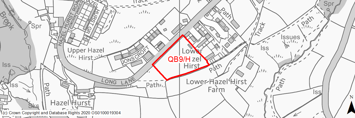
Site location
Local Growth Centre - Queensbury
Ward
Queensbury Ward
Site description
This is a reasonably level agricultural field but with a slight slope to the south. The boundaries of the site are formed of dry stone walls and a made road (Long Lane).
Proposed Allocation
Housing
SHLAA referencce
QB/035
Indicative no. dwellings
20
Site area (Gross) (ha)
0.84
Ownership
Private
Delivery timescales
Developable (11-15 years)
Type (PDL/Greenfield)
Greenfield
Green Belt
Yes
Flood Zone
Flood Zone 1
Potential site access
There is an existing field gate access off Long Lane, but improvements would be required to form an acceptable junction.
Public Transport Accessibility
The site is over 800m from a bus stop with a frequent service.
Sustainability Appraisal
The site could deliver major positive effects for residents on both the health and education SA Objectives as a result of being within the target distances for all necessary health facilities and centres for primary and secondary education.
Minor positive effects were predicted for a range of socio-economic themed SA Objectives due to the benefits of new residential development for the local economy, although the location of the site does not allow for good access to transport links or local amenities.
No major adverse effects have been predicted for the site, but minor adverse effects were predicted for a range of natural environment themed SA Objectives, primarily as a result of the impacts of new development on a 100% greenfield and Green Belt site which is 90m west of Shibden Head LWS.
Habitats Regulations Assessment
This site falls within 7km of the South Pennine Moors SPA/SAC. A HRA must be undertaken to ensure there are no significant effects on these protected sites. Developments within these zones must comply with Policy SP11; a SPD is being produced to provide further guidance.
Green Belt
Based on planning judgement the site has a moderate potential impact on the Green Belt.
• The site is located in a moderate Green Belt parcel.
• The site makes a moderate contribution to the purposes of including land within the Green Belt.
• The site has a moderate potential for sprawl and would have a major impact on the openness of the Green Belt.
• There is limited opportunity to create a stronger Green Belt boundary than the existing boundary.
Constraints and Opportunities
• The site is currently designated as Green Belt, and the site specific Green Belt assessment indicates that it has a moderate potential impact.
• Development of the site would have a moderate impact on the landscape.
• The site is partly within a Green Infrastructure Corridor and development may provide an opportunity to enhance it.
• The site is located within the 7km buffer of the SPA/SAC.
Development considerations
• Provision of compensatory improvements to the surrounding Green Belt will be required and may include enhancement of the existing rights of way network and Local Wildlife Network adjacent to the site.
• A sensitive design to mitigate any potential landscape impact, which may include consideration of layout and provision of screening where appropriate.
• Vehicular and pedestrian access is available off Long Lane, although a new junction will be required.
Conclusion/Summary
This is a reasonably level site, sustainably located adjacent to the settlement boundary and is contained on two sides by existing residential development. It would deliver an estimated 20 dwellings and is in close proximity to local sports facilities.