
Draft Bradford District Local Plan - Preferred Options (Regulation 18) February 2021
Menston
Introduction
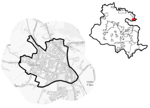
5.18.1 Menston is located in the Wharfe valley. The settlment is located roughly 11km north of Bradford, 7km south west of Ilkley and 16 km north east of Leeds City Centre. The settlement lies to the south of the River Wharfe. The nearest settlements being Burley-in-Wharfedale to the north west and Guiseley in the Leeds District to the south east. To the south of Menston is a residential area in the Leeds District, formed from conversion of the former High Royd's hospital site. Rombalds Moor lies to the west.
5.18.2 The settlement is predominantly residential, expanded from a historic village centre. It is split into three main areas divided by the railway line, the A65 and A6018 leading up to Otley Chevin. The settlement is served by a primary school, local convenience shops and services, a small local supermarket, post office, public houses, churches, community centre and library. Menston is located within the Shipley Parliamentary constituency in the Wharfedale ward. Menston Parish Council acts an administrative body for the parish area.
5.18.3 The settlement area has a population of 4,322 residents. The working aged population is 2,355 (54.5%) which is lower than the West Yorkshire average of 62.8%. People aged over 65 make up 27.5% of the population, which is above West Yorkshire average of 16.7%. Ethnic composition is primarily made up of people who identify themselves as White British (96%). This is a higher proportion than the West Yorkshire average (78.4%) but similar to other rural areas of the District.
Figure 1: Location Plan
Planning for Prosperity
15.18.4 The Local Plan settlement hierarchy identifies Menston as a Local Growth Centre within the Wharfedale sub area. This means that Menston is a location which has been promoted to the third tier of the settlement hierarchy due to its role and function. It is a sustainable local centre and is accessible to larger settlements such as Ilkley and Bradford due to access to public transport via the train station. This growth will reflect a balance between the contribution that development can make to meeting housing need but also reflecting a number of environmental constraints. The plan will also support limited retail and leisure development within Menston Local Centre to meet day to day needs and benefit from excellent road and/or rail links.
15.18.5 Menston is identified as one of the least deprived areas in the Bradford District. The Wharfedale Ward is the least deprived ward in the District for the Index of Multiple Deprivation and is least deprived for both income and employment deprivation. In Menston 0.1% of households are suffering from multiple deprivation, compared to a West Yorkshire average of 0.7%.
Economy and Employment
15.18.6 There are a number of employers in Menston, including in shops and supermarkets, stone merchants, kennels, gyms, beauticians, hairdressers, funeral directors, car dealerships, printers, newsagents with Post Office, golf equipment suppliers, taxis, public houses, takeaways, cafes, delicatessen and a pharmacy. The Kirklands community centre also provides volunteering opportunities at the library and to help run the centre. The three largest groups for work force based jobs in Menston are Health, Education and Business administration & support services. In Menston, the largest local business unit is Professional Scientific and technical services, second is construction and the third largest is Post & Telecommunications. Almost 90% of these businesses employ 0 to 4 people.
15.18.7 Of all adults aged between 16 and 74, 2,218 are economically active. This is higher than the West Yorkshire average. The average annual household income of £54,600 is significantly higher than regional West Yorkshire average of £38,499.
15.18.8 No specific employment allocation is proposed for this Local Growth Centre, although under Policy SP6 economic growth and investment will continue to be supported, particularly with a focus upon the priority sectors within the Wharfedale corridor of health, digital and professional services.
Retail
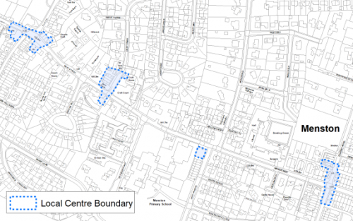
15.18.9 Menston has a designated Local Centre, however there is no single local centre boundary. The centre's retail and service facilities are instead distributed in clusters along a stretch of Main Street & East Parade. The Convenience offer is anchored by the Co-op Food Store and there is a Sainsbury local store on the A65 but this is outside the area considered by the retail and leisure study. Compared to national averages, Menston is over represented by convenience uses. There is only one single unit in comparison use, a chemist close to the junction of Main Street & Cleasby Street. The comparison offer is significantly lower than the national average considered to be characteristic of centres of this size. Leisure services include two pubs, two takeaways and a sandwich shop. These are mostly located at the western end of the centre at the junction of Main Street and Burley Lane. Community facilities include a GP surgery, Menston Primary school, Kirklands Community Centre and Menston library. At the time of the retail and leisure survey in 2019 there was one vacant unit on Cleasby Road.
15.18.10 Menston fulfils the role of a local centre which caters to the basic daily needs of the immediate population with other and more specialist functions & requirements being met in larger nearby centres such as Baildon or Ilkley. The Retail and Leisure Study (2019) suggests that the dispersed nature of the centre could impact on its viability. There is a general lack of offer beyond daily convenience and service needs and poor parking options and availability. Figure 2 shows the location of the Local Centre.
Figure 2: Menston Local Centre
Transport and Access
5.18.11 Menston is located along the A65, which provides excellent road connections to Leeds and Bradford via Shipley along Bradford Road/Otley Road. Menston has good public transport links with a frequent train service and bus stops throughout the centre. There is a station which provides a regular train service to Ilkley, Leeds and via Shipley to Bradford Forster Square. On-street parking is predominant throughout the Centre. There are some dedicated parking spaces at Menston library / Kirklands community centre The area is primarily a commuter settlement.
5.18.12 Bus stops are located throughout the centre but regularity and service destinations vary between them The area is served by several high-frequency (every 15 to 20 minutes) bus routes with services linking to Otley and Leeds. Only 13% of all households have no car, compared with 29.4% across West Yorkshire.
5.18.13 There are numerous footpaths and bridleways leading out of the settlement into the countryside and connecting with the wider public rights of way network. Proposals for the Wharfedale Greenway, which would link Menston with Burley, Addingham and Otley with a traffic free route for safe walking and cycling, are supported in the plan which will seek to safeguard a route following further detailed feasibility work for when funding allows implementation.
Table 1: Menston Transport Projects
|
Policies Map Ref. |
Project Name |
|
TR1.A.5 |
Wharfedale Greenway (walking and cycling) |
5.18.14 In relation to digital connectivity the average broadband download speed is 29.74 Mbytes which is slower than 44.6 Mbytes West Yorkshire average. There are no households with broadband speeds below the Universal Service Obligation level
Planning for Homes
5.18.15 There are 1,979 dwellings within the settlement area which consist of 85% owner occupied, 1.1% of these are local authority rented, 4% housing association rented and 9.6% private / other rented tenure.
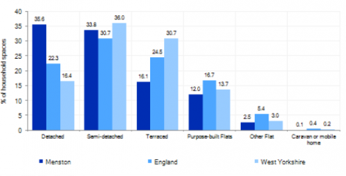
5.18.16 Menston is predominantly an area of residential estates of varying ages and predominantly detached and semi-detached properties. There is an area of terraced and back to back properties in the older part of the settlement which dates back to 971 AD. The area has a varied mix of house types with majority detached (35.6%), which is much higher than regional and national averages, semi-detached (33.8%), with older terraced properties accounting for 16.1% and purpose built flats (12%), which is below the regional average. Figure 3 below provides further information.
Figure 3: Menston – Dwelling Type Breakdown
5.18.17 The average house price is £330,569 for all house types, which is much higher than the District and West Yorkshire average of £183,194. The total affordability ratio between house prices and annual earnings which is usually used as a proxy for number of years' worth of earnings required for a house deposit is 4.2 compared to a West Yorkshire average of 2.96. Affordability is therefore an issue for newly forming households wanting to live in the area.
5.18.18 Delivering new housing is a key part of the overall development strategy for Menston. It will ensure that the housing needs and aspirations of local people can be met, together with those of future residents, including market and affordable housing. In addition, it will support services in the Local centre.
5.18.19 Policy SP8 in the local plan sets out a minimum requirement of 350 dwellings to be delivered during the plan period. These will be delivered through a mix of committed sites (those under construction or have planning permission but have not yet commenced) and site allocations. Table 2 below sets out the housing position for Menston, which also includes the application of non-implementation or discount rates for planning permissions and allocations.
Table 2: Menston - Summary of Housing Requirement and Supply
|
Housing Target |
350 units |
|
Carried Forward Commitments |
207 |
|
Commitment Discounted by 10% |
186 |
|
Remaining Allocation Requirement |
164 |
|
Identified Allocations |
201 |
|
Allocations Discounted by 10% |
181 |
|
Total Supply Contribution from Allocations |
181 |
5.18.20 Once the commitments are discounted and removed from the supply this leaves a residual allocation requirement of 164 units. The evaluated total site supply of housing units from preferred allocation sites equates to 201 units which is in turn discounted by 10% for non- implementation or reduced delivery leaving a final allocation contribution of 181 units across all sites, which is slightly above the remaining allocation requirement (164 units) but is reflective of site yield of identified sites. The Council will be supportive of additional proposals for new homes on additional small sites, particularly those that provide a redevelopment opportunity to bring forward land which has been previously used. Support will also be provided to developers who wish to redevelop larger sites and/or buildings for new homes not currently identified, subject to all relevant policies in the Local Plan.
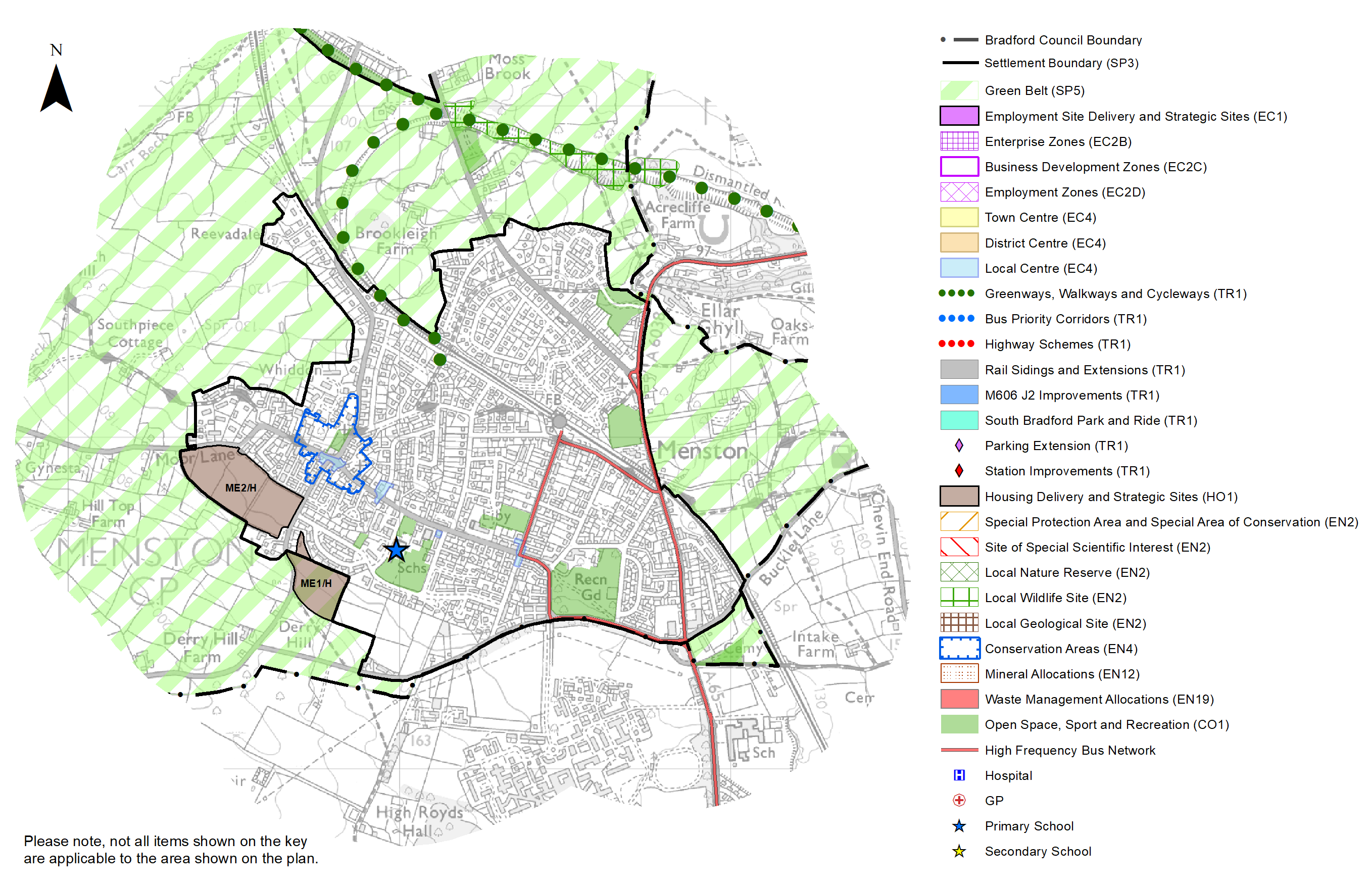
5.18.21 The area is constrained by Green Belt with no brownfield growth options available. Menston's allocation mix of two sites is two greenfield sites, one of which is within the urban area, whilst one falls within the current Green Belt. In delivering the target for new homes in Menston it has been necessary to make some changes to the adopted green belt. Policy SP5 sets out The Councils approach and justification for green belt releases to accommodate new development and lists the sites proposed for allocation which current lie within or partly within the green belt. The Local Plan preferred site allocations for residential allocations to meet the Menston housing requirement are set out in Table A and identified on the Policies Map and the Site Pro Formas below together with the local strategies map for each plan area.
5.18.23 Development of site allocations should be in accordance with specified development guidelines and approximate site provision figures and all other relevant policies of this Local Plan.
Planning for Places and Communities
Green Belt, Natural Landscape and Historic Character
5.18.24 Menston is located in the Wharfe Valley. The village is constrained by Rombalds Moor to the west, which acts as a backdrop to the village, which is designated as Green Belt and South Pennine Moors Special Protection Area. The majority of this landscape is of high sensitivity. Green Belt designation surrounds Menston except to the South of the settlement, on its border with the High Royds Estate.
5.18.25 Menston is part of the Wharfedale Character Area. Wharfedale corresponds to the major broad, deep, glacial river valley of the Wharfe. The Wharfe and Aire Valleys are separated by Rombalds ridge. The settlements of Wharfedale have well defined edges with substantial woodlands and tree cover giving the valley a more enclosed and 'lush' character. Menston is one of these settlements. The Landscape Character assessment allocates the typology to the areas outside and surrounding the built up area of Menston as Enclosed Pasture, which is moderately sensitive.
5.18.26 Within Menston there is one Conservation Area and there are 13 Listed Buildings, Fairfax Hall is Grade II * and 12 are grade II Listed. Menston was one of a number of farming communities which had developed along the Wharfe valley. In 15th Century there was a separate Manor hall within the feudal estate of the Archbishop of York. By the 17th Century Menston experienced unprecedented changes during the industrial revolution which transformed the village into a thriving settlement. The village expanded into the 20th Century after the 2nd World War which saw many new housing developments expanding onto the green fields around the village, particularly around the station area. The Conservation Area boundary covers the old settlement of Menston, which retains elements from various stages in its early history and development and is based around the junction of Main Street, Derry Hill & Burley Lane.
Green Infrastructure (GI), Ecology, Open Space and Flood Risk
5.18.27 Menston has a network of green spaces and green corridors, linking the settlement to the wider countryside. The Disused Railway line to the north of the settlement forms an important green infrastructure corridor and habitat network. The main GI corridors are detailed below in Figure 4.
Figure 4: Green Infrastructure Corridors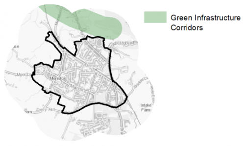
5.18.28 Menston is bordered by countryside to the South West. Most of the area lies within Zone B, (2500m) of the South Pennine Moors Special Protection Area, (SPA), and areas on the Eastern edge of Menston are within Zone C (7000m) of the SPA. A small area of the settlement is outside the SPA zones. There are no ancient woodlands, or formal wildlife designations within the settlement itself.
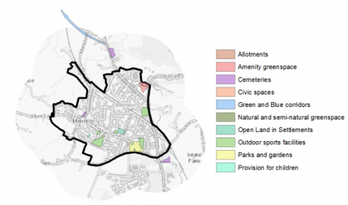
5.18.29 In regards to formal open space, Menston has 9.87ha of open space across 15 sites. Key siteswithin the Menston settlement area include:
- Menston Recreation Ground
- Menston Cricket Ground
5.18.30 There is a significant deficit in provision with less than half the amount of required open space being available within the settlement area. There is also an imbalance between the different typologies of open space that currently exist in the settlement. Within four typologies, there is no provision within Menston, for Allotments, Civic, Green and Blue Corridors and Natural and Semi-natural Greenspace. Key public spaces such as Menston Park and the play area sites are also concentrated in the southern half of the settlement. In terms of distribution there are large residential areas to the north which have limited or no immediate open space provision. Additional play area space to the north of the settlement would benefit residents and help to ensure better access to facilities.
5.18.31 Of particular note is the deficit of and Semi-natural Greenspaces and provision of such space should be considered as a high priority where opportunities arise. However, Menston is surrounded by open countryside and this in part provides a substitute for the lack of space within the settlement. Other typologies which are a high priority for increased provision include Outdoor Sports space and Parks and Gardens. Although there is some existing provision, the offer for outdoor sports is fairly limited and the location of both types of space is limited to the southern part of the settlement. Additional provision to the north would help to both balance provision levels and the distribution of sites. There is also no existing allotment provision in Menston.
5.18.32 The converted development of High Royds hospital site, adjacent to Menston, provides an expanse of open space which residents of Menston can use but is outside the Bradford boundary in Leeds. This area includes a cricket ground, Lake and walking / wildlife area. Figure 5 below illustrates the location and type of open space provision in the settlement.
Figure 5: Menston - Open Space Overview
5.18.33 Menston has areas of fluvial flood risk along Mire Beck, to the East of the A65 with areas of higher flood risk within Flood Zone 3. Menston has limited areas of higher Surface Water Flood Risk and is identified as a groundwater flood hazard on the groundwater map. Groundwater flood risk should be considered on a site by site basis in development planning and should be considered particularly when determining acceptability of Sustainable Urban Drainage (SUDs) schemes as a way of managing surface water drainage.
Community Infrastructure – Education, Health and Utilities
5.18.34 Menston has a range of community facilities to meet the day to day needs of local people. These facilities include a primary school, healthcare facility, dentist, post office, places of worship, community halls/centres, playgrounds, and a library.
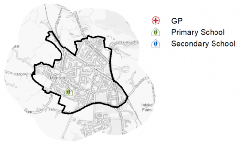
5.18.35 The area is served by one primary school (Menston Primary Schoool) There are no secondary schools within Menston but Menston is in the Ilkley Grammar secondary priority 2 zone. St Marys Roman Catholic school and Guiseley upper school are located close to Menston but outside the Bradford District boundary in Leeds. In Menston pupil attainment at both key stage 1,2, and 4 was slightly higher than the figures for England and West Yorkshire. Figure 6 shows the location.
5.18.36 Menston has an NHS registered healthcare facility within the settlement (Menston medical centre) Secondary (acute) healthcare is provided at Wharfedale Hospital, around 2km to the North East in Otley and Bradford Royal Infirmary around 12km to the South West. Figure 7 shows the location of local services in Menston. 5.18.37 Average life expectancy at birth for Menston residents is higher than the West Yorkshire and England average, with healthy life expectancy of 84 for men and 87 women.
5.18.38 When planning for the long-term development, it is vital that new development is supported by the appropriate infrastructure. The capacity, quality and accessibility of services and facilities are all key components in ensuring people can enjoy living, working and visiting the area. The Council will continue work with key infrastructure providers and others including the Local Education Authority, Clinical Commissioning Group and utilities providers to determine the impacts of future growth and development on local infrastructure capacity and provision. Further infrastructure details will be published through the Local Infrastructure Plan and as part of the Regulation 19 stage of the local plan.
Figure 6: Schools in Menston
Local Area Strategy and Plan – Menston
The key elements of the local area strategy for Menston include:
The identification of the area as a Local Growth Centre and a sustainable location for housing growth in the District. The area contains two new housing sites. These sites will provide market and affordable housing and support services and facilities within the designated local centre and will deliver 201 new homes alongside others with current planning permission.
Supporting the vitality and viability of the Menston Local Centre.
Supporting safe active travel routes (cycling and walking) through neighbourhoods, to services and facilities including the delivery of the Wharfedale Greenway in the plan and seek to safeguard a route following further detailed feasibility work for when funding allows implementation.
Continue to protect important areas of open spaces, and seek opportunities to increase provision of allotments, parks and natural and semi natural green spaces where possible. In particular, to the North of the settlement
(10) Consultation Question 122
Menston Local Area Strategy
The Local Plan sets out a local area strategy for Menston.
Q. Please provide any comments you may have on the area strategy?
If you have an alternative to the approaches undertaken, please provide further details and evidence in support.
Preferred Site Allocations and Site Pro Formas
5.18.39 The preferred housing site allocations are detailed below in Table A. This table is followed by site pro formas for each preferred site allocation proving a summary of key site information and characteristics.
Table A: Menston: Housing - Preferred Allocations
|
Site Ref |
Site Name |
Dwellings / Other Uses |
|
ME1/H |
Bingley Road |
40 |
|
ME2/H |
Derry Hill |
161 |
|
Total |
201 |
(10) Consultation Question 123
Menston: Site Allocations and Site Pro Formas
The Local Plan sets out a series of preferred site allocations. If you wish to make representations on any of the sites proposed, please provide site reference and feedback under this question.
If you wish to propose an additional or alternative site(s) to the preferred allocations listed, please also provide a plan with a red line and any further details in support.
(12) ME1/H - Bingley Road
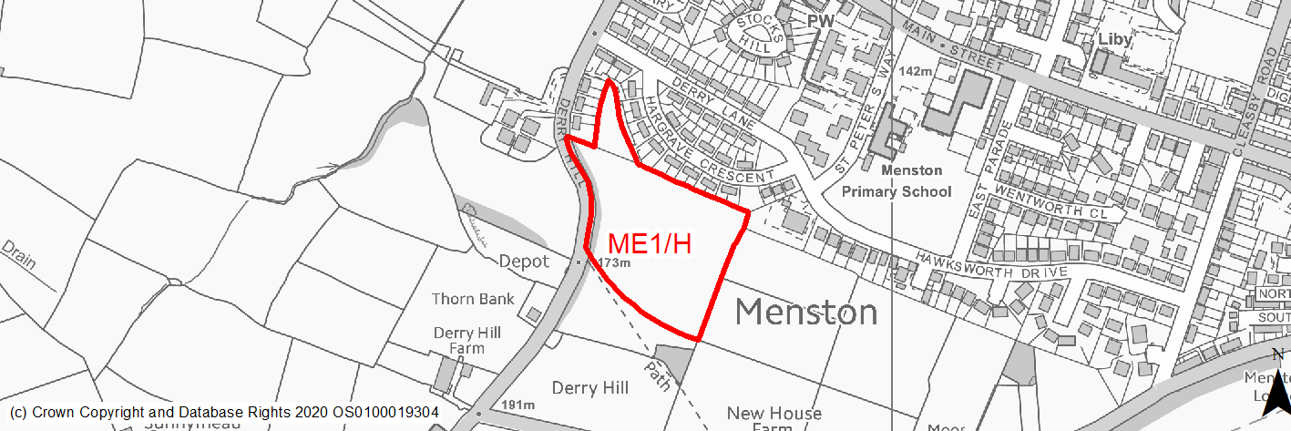
Site location
Local Growth Centre - Menston
Ward
Wharfedale
Site description
The site adjoins the existing built up area to the south west of the settlement. The site consists of open fields bounded by a stone wall along the road (Derry Hill) to the west and residential properties to the north. There is a group of mature trees along on road boundary (Derry Hill) to the west. The site steeply slopes down from the south to the north. Most of the site lies within the green belt.
Proposed Allocation
Housing
SHLAA referencce
ME/002
Indicative no. dwellings
40
Site area (Gross) (ha)
2.3
Ownership
Private
Delivery timescales
Deliverable/Developable (0-11 years)
Type (PDL/Greenfield)
Greenfield
Green Belt
Yes
Flood Zone
Flood Zone 1
Potential site access
There is potential access to the site from the development site to the east. Any access onto Derry Hill will likely cause highway safety issues.
Public Transport Accessibility
Bus: The site is not located within 400m of a bus stop with at least four services every hour.
Rail: The site is not located within 800m of the nearest railway station (Menston).
Sustainability Appraisal
The site could deliver a major positive effect for residents on the health SA Objective as a result of being within the target distances for all necessary health facilities.
Minor positive effects were predicted for most other socio-economic themed SA Objectives due to the benefits of new residential development for the local economy, as well as the location of the site in relation to local services and amenities and education facilities. However access to transports links is somewhat limited, due to the distances involved and poor pedestrian and bicycle access.
No major adverse effects have been predicted for the site, but minor adverse effects were predicted for a range of natural environment themed SA Objectives, primarily as a result of the impacts of new development on a 100% greenfield and Green Belt site containing trees. The site falls within the SSSI Impact Risk Zones for the South Pennine Moors SAC/SPA/SSSI, which is 1.5km west of the site, meaning consultation with Natural England would be necessary as part of any planning application for 50 dwellings or more at this location.
Habitats Regulations Assessment
This site falls within 2.5km of the South Pennine Moors SPA/SAC a HRA must be undertaken to ensure there are no significant effects on these protected sites in terms of impact on supporting habitat which might be functionally linked to the SPA and recreational pressures. Developments within these zones must comply with Policy SP11; an SPD is being produced to provide further guidance.
Green Belt
Based on planning judgement the site has a moderate potential impact on the Green Belt.
• The site is located in a moderate Green Belt parcel.
• The site makes a moderate contribution to the purposes of including land in the Green Belt.
• The site has moderate potential for sprawl and would have a moderate impact on openness.
Constraints and Opportunities
• The site is located within the 2.5km buffer of the SPA/SAC and SSSI impact zone.
• Areas of protected mature trees along western boundary.
• PROW adjacent to the southern boundary of the site.
• Site locted just beyond Core Strategy Accessibility Standards.
• New access required through new development to the east. Direct access onto Derry Hill not considered acceptable.
• Landscape impacts - long views over the site from the south should not be obstructed by any development.
Development considerations
• Ecological surveys to identify any impacts and mitigate accordingly.
• SPA/SAC Zone B - habitat mitigation required.
• New and enhanced GI links through the site.
• Sensitive site design to mitigate any impact on landscape character. Any built development to avoid the steeper slope to the south.
• Provision of new vehicular access from Bingley Road site to the East. If access is considered acceptable then the total number of dwellings for both sites should be less than 200 dwellings.
• Development to protect and incorporate existing trees with buffer from Western boundary and increase the overall tree cover.
• Improved pedestiran and cylce links through and to the site.
• Compensatory Green Belt enhancement required.
Conclusion/Summary
This is an available site currently located in the Green Belt adjoining the settlement boundary, which would deliver an estimated 40 dwellings.
(8) ME2/H - Derry Hill
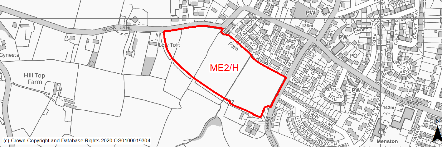
Site location
Local Growth Centre - Menston
Ward
Wharfedale
Site description
Greenfield allocated housing site on edge of the village. The site consists of open pasture fields with some mature trees/hedgerows within the site and along the boundaries. Pending application for 161 new homes. Now approved in principal.
Proposed Allocation
Housing
SHLAA referencce
ME/003
Indicative no. dwellings
161
Site area (Gross) (ha)
5.44
Ownership
Private
Delivery timescales
Deliverable (0-5 years)
Type (PDL/Greenfield)
Greenfield
Green Belt
No
Flood Zone
Flood Zone 1
Potential site access
Access to the site is available via Derry Hill and Moor Lane. Both will require a new access.
Public Transport Accessibility
Site does not meet Core Strategy accessibility standards but site has approved planning permission.
Sustainability Appraisal
No significant adverse or beneficial effects have been predicted. Minor adverse effects were predicted for most other natural environment themed SA Objectives, primarily as a result of the impacts associated with new development on greenfield.
The site would generally provide residents with good access to key services and amenities, including shops, cultural spaces, jobs, schools, health facilities and public transport. However, the site is not within all target distances for any socio-economic themed SA Objective (i.e. no major positive scores predicted).
Habitats Regulations Assessment
This site falls within 2.5km of the South Pennine Moors SPA/SAC a HRA must be undertaken to ensure there are no significant effects on these protected sites in terms of impact on supporting habitat which might be functionally linked to the SPA and recreational pressures. Developments within these zones must comply with Policy SP11; an SPD is being produced to provide further guidance.
Green Belt
N/A – Site not within the Green Belt.
Constraints and Opportunities
• The site is located within the 2.5km buffer of the SPA/SAC and SSSI impact zone.
• Areas of protected mature trees along site boundaries.
• PROW through the northern boundary of the site.
• Site located just beyond Core Strategy Accessibility Standards.
• Flood risk- part of the site at medium/high surface water flood risk.
Development considerations
• SPA/SAC Zone B - habitat mitigation required.
• New and enhanced GI links through the site.
• Sensitive site design to mitigate any impact on landscape character.
• Provision of new vehicular access from Moor Lane and Derry Hill.
• Site specific FRA and mitigation of surface water flood risk/drainage issues.
• Development to protect and incorporate existing trees and increase the tree cover.
• Improved pedestiran and cylce links through and to the site.
Conclusion/Summary
This is a sustainable greenfield site within the settlement boundary, which would deliver an estimated 161 dwellings.